Just a quick update on the deep moisture feed from deep in the Gulf Of Mexico. The IR picture clearly shows this moisture streaming up the Appalachians and towards the Mid-Atlantic states. This moisture plume is poised to dump copious amounts of rainfall over PA during the mid-week period. Note Katia off to the east of the Bahamas.
Speaking of plumes, here are the plume diagrams from the Short Range Ensemble Forecasts (SREF) showing that most of the runs indicate at least a 4" rain event to affect KMDT. Let's hope that 11"+ run doesn't verify! I usually like to use these plumes for winter weather precipitation events, but the quantity of the rainfall can be quickly analyzed with these plots.
As can be done with a normalized plot on a map. However, when normalizing the model output, the extremes are smoothed and often what is mapped is less than what actually falls from the sky. That is not a good scenario for the Mid-Atlantic as seen below. This map is quite disconcerting for the flooding potential that will occur over PA later this week. And the Susquehanna is not outside the possibility of flooding either as this rainfall would be onto already saturated ground....nearly 100% runoff. Here is that most concerning map.
As for Katia, the upper air graphic below argues that Katia could just as easily be pulled towards the continent as getting swooshed out to sea by the westerlies. The ridge to her east and the trough to her west are in such a position that this hurricane could get moved either way. If the trough is just a bit deeper to the west or the ridge just a bit higher to the east, that storm will hit the US, likely on Long Island and then up into New England. Either way, very large surf will be present all up and down the east coast this week.
So off to finish watching the Phillies...here's hoping they get 5 innings complete as some fairly heavy rain is on the doorstep at the Bank!
Enjoy your Tuesday.
Smitty
AA: Heavy rain a near certainty this week with us receiving ~5" in total by Thursday!
Smitty's attempt to educate and to a much lesser extent, entertain, about all facets of life; but primarily the meteorological and the climatological aspects of the earth sciences.
Monday, September 5, 2011
Ug-Lee Week Ahead
Weatherwise, we will have an U-G-LEE week as the tropical moisture fetch streams northeastward from the remnants of Lee. Poised just to our west this morning is a strong frontal boundary separating very humid air to the east (we are in the soup this am) and very autumnal air to the west. You can clearly see this divide as per the water vapor image below. Note how the dry air has moved south all the way to gulf coast of western LA and TX! At DFW the winds are northerly at 20 gusting to 40 with a dewpoint of 45 as of 6 am! Shreveport, LA has similar surface conditions. remember, the black is very dry whereas the white is very wet in the middle and upper levels of the atmosphere. That large moisture blob is moving northeast and WILL affect our wx here in PA for most of the upcoming week.
Here is the latest computer generated precip for the eastern US as per the GFS through next weekend. Look at that bulls eye of 10+" rainfall over central PA! I guess some sump pumps will be getting a workout this week.....ouch!
You can also see the path of Katia and that the GFS keeps this storm well offshore....and that is a good thing. But not all of the modeling is in agreement as the Canadian (Reggie is its nickname in the meteo circles (GGEM)) clearly has an east coast situation that the people of NJ, LI, and New England just don't want to see! This map is progged for Friday afternoon!
And Katia is beginning to strengthen quite nicely as it has moved into a very favorable location atmospherically overnight....take a look at this Cat 2 storm with a beautiful eye! This is an IR pic, the visible is not as contrasting due to the sun angle at this early time of day. But I'll post it anyway....
Here is the visible cloud shot of Katia early Labor Day morning.....
So lots of wx this week. As the week progresses, we will see how Katia pans out for the northeast US. It is still not out of the question that this storm does DIRECTLY affect NJ or points north. And if you believe the UKMET, the Outer Banks of NC are not out of harms way as of this posting. But the official wx map from the NWS looks something like this for Friday this week with Katia moving away from the US Mainland. Time will tell......
So wild is the weather word this week. Wild like the Phillies game on Sunday in south FL where the Marlins left 23 on base in the 14 inning marathon. But the real story of that game is that replay has now been made arbitrarily the manner in which to judge and officiate ALL calls, not just home runs! Cowboy Joe West seems to think that "after further review" should not be relegated to the NFL any longer. Charlie seemed to think that was not kosher and was asked to leave the game without West listening to any of his rationale! Charlie played the game in protest. And now we wait and see what the spineless commissioner will do...but the Phillies should have won the game by regulation as they were a lofty 2 for 12 with runners in scoring position! Oh well.......
You go Charlie!
Have a great Labor Day....albeit a wet one. Etters is reporting 1.56" so far thanks to the overnight storms! The week long deluge has begun....
Smitty
AA: Wet week with tropical remnants of Lee affecting us with the potential of easily seeing 6" of rain by Friday. Hoping that Katia stays out to see. Phils in a lengthy game played under protest yesterday in Miami.
Sunday, September 4, 2011
Lots of Water Available for Rain
The water vapor image above shows very nicely ALL of the fuel the atmosphere is holding in terms of the creation of showers and thunderstorms over the upcoming several days. The strong front that is currently over the Midwest will slowly move eastward over the next 36 hours. As it does, this will most certainly create the little bit of umph to get the air in our area to discharge storms later Sunday and all day Labor Day. If you scrutinize the WV image, you'll see the flow pattern across the US and note that the flow is parallel to the front (in IA and WI) and that is why the front will limp through PA later tomorrow. It is also easy to see Lee swirling in the northern gulf. Note the pocket of very dry air at the western edge of the map on the NV CA border marking the driest place in North America; Death Valley!
The guidance for Lee is very erratic at best. However, the global models have been consistent in moving Lee up the spine of the Appalachians delivering copious amounts of rainfall over the eastern US this upcoming week. First the "spaghetti" looking guidance from the tropical models for Lee. Note how some of the models take this storm to SE TX, some to MO, and some to PA and points northeast......
And now the total rainfall modeled by the GFS through next weekend. Central and southeastern PA is looking at ~5" of rain.....and that is if Katia stays out to sea....and that is a HUGE IF since 2 of the global models are now beginning to bring Katia much further west and the moisture if not the wind field will certainly have an impact on the along the coast and possibly a bit inland.
Here is the modeling for Katia again first with the "spaghetti" of the tropical models.
If the trough out over the northern plains translates across the US and deepens as it does so, then the recurve of Katia is nearly certain. However, if that trough "misses" Katia, all bets are off and Katia could and more likely will impact the coastal US. Yesterday it was appearing the trough would deflect Katia towards the fish. Today, the consensus is not as great. So we will see how the global pattern evolves. Here is the worst global model where Katia is farthest south and west and would most certainly affect the eastern US, quite adversely I might add. This is the UKMET (England's) and is often capable of sniffing out the global patterns as astutely as the Euro and the GFS. That map below is ugly for any/all east coast interests. Note the placement of Lee in TN with the inverted trough moving into OH and sw PA! That map is actually very exciting in a "sick" way!
Below if the official forecast map for Wednesday. If Katia is a bit further south and west at that point, then the moisture from Katia in the upper levels of the atmosphere will most certainly become entrained into the now baroclinic Lee.
Have a great Sunday!
Smitty
AA: Showers and storms frequent through Monday. Then watching the moisture from Lee Tuesday pm to Thursday. Then watching Katia. We are lucky to have a job this labor day holiday!
The guidance for Lee is very erratic at best. However, the global models have been consistent in moving Lee up the spine of the Appalachians delivering copious amounts of rainfall over the eastern US this upcoming week. First the "spaghetti" looking guidance from the tropical models for Lee. Note how some of the models take this storm to SE TX, some to MO, and some to PA and points northeast......
And now the total rainfall modeled by the GFS through next weekend. Central and southeastern PA is looking at ~5" of rain.....and that is if Katia stays out to sea....and that is a HUGE IF since 2 of the global models are now beginning to bring Katia much further west and the moisture if not the wind field will certainly have an impact on the along the coast and possibly a bit inland.
Here is the modeling for Katia again first with the "spaghetti" of the tropical models.
If the trough out over the northern plains translates across the US and deepens as it does so, then the recurve of Katia is nearly certain. However, if that trough "misses" Katia, all bets are off and Katia could and more likely will impact the coastal US. Yesterday it was appearing the trough would deflect Katia towards the fish. Today, the consensus is not as great. So we will see how the global pattern evolves. Here is the worst global model where Katia is farthest south and west and would most certainly affect the eastern US, quite adversely I might add. This is the UKMET (England's) and is often capable of sniffing out the global patterns as astutely as the Euro and the GFS. That map below is ugly for any/all east coast interests. Note the placement of Lee in TN with the inverted trough moving into OH and sw PA! That map is actually very exciting in a "sick" way!
Below if the official forecast map for Wednesday. If Katia is a bit further south and west at that point, then the moisture from Katia in the upper levels of the atmosphere will most certainly become entrained into the now baroclinic Lee.
That upper level scenario would look something like this......note how the isobars join from Katia to the upper level weakness over the TN Valley. This is potentially a very wet scenario for the piedmont as the air would orographically be lifted from sea level!
So....much to watch this weekend weatherwise. Enjoy your Labor Day weekend. Kind of a misnomer since at least 1 in 10 Americans are not laboring in this political policy crushing economy. Maybe in 14 months, the public will choose for economic growth and not these progressive socialistic ideals that have gotten most of the world economy in the tank! This is the UE rate in PA...Have a great Sunday!
Smitty
AA: Showers and storms frequent through Monday. Then watching the moisture from Lee Tuesday pm to Thursday. Then watching Katia. We are lucky to have a job this labor day holiday!
Saturday, September 3, 2011
A Very Wet Week Is In Store
It is becoming painfully obvious that the remnants of TS Lee will get entrained into the fronts that will be moving grudgingly slowly across PA this weekend and upcoming week. Below is the recent IR satellite pic of the US. You can clearly see the fronts out over the upper Mississippi Valley in the form of clouds. Also readily seen is Lee in the Gulf of Mexico where upwards of 15" of rain is not out of the question for Cajun Country.
The map below is the weekly precip progged by the GFS over the eastern part of the US. You once again are able to see the trail of rain that Lee will leave in its wake as it becomes absorbed by the frontal systems that will traverse the eastern US this week. Lee's moisture will then get advected NE and up into New England before it becomes lost in the strong westerlies just north of our latitude. Those pockets of 7+ inches in the Catskills and VT do not bode well for the flood ravaged areas thanks to Irene. One can also note the projected path of Katia; most models keep Katia at sea, but just be aware there is still a slight possibility some of her moisture becomes involved with our wx as well by the end of this upcoming week......This is one wet map!
So this week we will have ample opportunity for the lots of rain. It basically could rain at any time from when you are reading this through late Wednesday. Although I'm not convinced, I believe this weekend should be nice weatherwise as Katia pulls away and slams into Nova Scotia. Here is the current guidance for Katia as per the models.
And here is the official forecast from TPC (Tropical Prediction Center). If Katia gets to 30N, 75W, then the east coast will have great concern as this will then most likely impact someplace along the US east coast DIRECTLY!
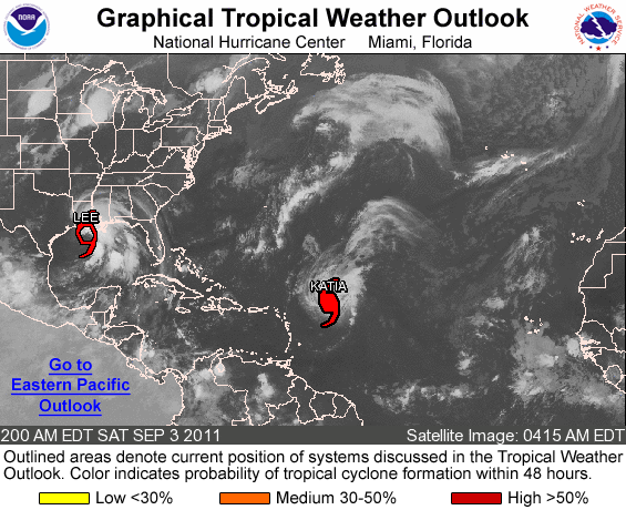
Here is where these 2 storms are located as of early Saturday morning.....
Lee will quite likely be the major player for the entire eastern half of the US as shown by the modeling on this very ominous tropical storm. Remember that Agnes (1972) was "only" a tropical storm for all but a half a day of its life! I'm not saying this is Agnes, but Lee will deliver copious amounts of rain up and down the Appalachians this week and many places WILL experience flooding once again!
Here is the progged location of both storms as per the GFS late Sunday. The major difference between the GFS and the Euro is that the Euro is about 12 hours quicker with Lee pulling northeastward. Here are the storms for Sunday morning......
And here are the locations by Tuesday evening......
And the last map I leave you with is the official forecast for Wednesday morning. I believe that Lee will be further north and east as of this time. Here we go again....with lots of rain, wind will not be as bad?
88-46; 0.657; 8.5 game lead over the Braves. This is the greatest win percentage the Phillies have ever had at this point in the season. 28 games remain this season. How many games can the Phils win in this regular season? Just goes to show what solid pitching can do AT ALL LEVELS of the game! Pound the strike zone, don't give bases on balls, don't give extra outs via errors.....baseball is a very simple game. And all of this baseball talk with the 1st week of high school and college football kicking off. What goes? Too many questions for football season in its infancy....although it does appear that Coach Chaump is creating a winner on Rutherford Road!
Have a great Labor Day Weekend....and stay dry!
Smitty
AA: It could rain and/or storm at almost any time now through Labor Day......more rain to come Tuesday-Thursday thanks to Lee. The Phillies are awesome this year!
Wednesday, August 31, 2011
Weekend Worries
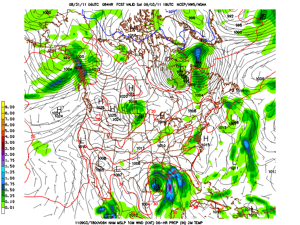
Just a very brief update as to what is occurring over the eastern part of the US the next several days. Below is the NAM showing what should be listed as a tropical depression within the next 24 hours. This disturbance will become better organized and eventually turn into a tropical storm or even a low cat hurricane. The graphic below is for Saturday afternoon. Note the precip over PA at that time as well.
Here is the GFS for 36 hours later. This wider view shows not only the gulf storm a bit further east and weaker, but it shows the powerful hurricane Katia looming just off the south Atlantic coast. Most of the modeling to this point recurves Katia before she hits the east coast. It is waaay toooo early to buy that solution! Keep a wary eye on this potentially nasty east coast storm!
Best I can do at this time......pressed for time and computer issues......
Have a good mid-week!
Smitty
AA: Gulf hurricane this weekend and an east coast hurricane after Labor Day? Might get wet in the lift Friday night, but I'm not sold on that yet!
Here is the GFS for 36 hours later. This wider view shows not only the gulf storm a bit further east and weaker, but it shows the powerful hurricane Katia looming just off the south Atlantic coast. Most of the modeling to this point recurves Katia before she hits the east coast. It is waaay toooo early to buy that solution! Keep a wary eye on this potentially nasty east coast storm!
The last graphic shows the potential snafu for this first week of the 2011 version of Friday night lights. As the WRF shows, there is most certainly a patch of unsettled weather located over the commonwealth. As to where this precip will end up in the early evening of Friday night, again this is too early to determine as there is really no catalyst to create any true dynamics and get better organized as opposed to receiving just a smattering of showers over a 24-48 hours period centering on this weekend.Best I can do at this time......pressed for time and computer issues......
Have a good mid-week!
Smitty
AA: Gulf hurricane this weekend and an east coast hurricane after Labor Day? Might get wet in the lift Friday night, but I'm not sold on that yet!
Monday, August 29, 2011
Krazy Katia
This is the Euro's solution of the atmosphere around North America 10 days hence. As you can clearly see, there is a hurricane east of the Bahamas. This is a very deep cyclone with pressures around 928 mb as per the model outputs. The map above is a tendency map of the air pressures. The brownish colors are height falls where the blue colors are height rises. Height falls indicate lowering of pressures whereas height rises indicate the rising of pressures. They very basic way to interpret that map above is to determine that the hurricane will move where there is the least resistance or lowering of pressures. So based strictly on that map above, that hurricane would be moving westward towards FL then northward between the isobars paralleling the Appalachians. The hurricane would then try to move into the trough or the dip in the jet stream over the Great Lakes. Of course, this is just a static snapshot of a dynamically changing atmosphere. That trough would progress to over ME and New England and "pull" the cane towards the weakness. This would suggest another east coast type storm.....'tis the season!
Here is the basic graphic that is issued by the NHC as they monitor the development and evolution of what is now Tropical Depression 12. This will soon be named Katia....and will most certainly need to be watched carefully over the next week or two.
In closing, from what I understand, Steven Strasburg will be starting for Harrisburg Thursday evening in his last minor league rehab stint as he comes back from Tommy John surgery. There has been much debate as to why the Nationals are rushing him back from his injury so quickly, but truth be told, he is on the timescale TO THE DAY according to the organization with respect to his rehab. They want to try to get him 4, maybe 5 starts in September and face major league bats to better aid him in pitch selection and focus on command. And since he is on my one fantasy team, I say let's see what he's got! I just hope the few light showers that should fall this Thursday hold off for his start.
Enjoy your Tuesday!
Smitty
AA: Watching tropical depression 12 that will become Katia in a day or two. Must be watched! As should Strasburg as he comes to Harrisburg Thursday. Too bad there is a fantasy draft that evening!
Sunday, August 28, 2011
Goodbye Irene
With Irene winding down, it appears that this storm has behaved pretty much as expected. Much of the east coast experienced large scale beach erosion and the Delmarva was hit primarily at lowest tide. The Delmarva, however, seemed to report the greatest number of small tornadoes as is so often the case with these mesoscale atmospheric gyres. I have 2 graphics for you in terms of precip here in the Harrisburg area; the first is the radar derived precip from the State College Doppler Radar and the 2nd is cooperative observers reporting their storm totals as of 7 am.
And the co-op obs from Dauphin and surrounding counties.
If you're interested, here is the 24 graphic for rainfall in eastern PA, and the bulk of the Mid-Atlantic at our latitude. This is radar derived as well which tends to overdo the precip amounts.
Streams will be receeding by Monday morning as evidenced by the river forecast for the Swatara Creek at Hershey. The Susquehanna will crest later Wednesday but well below flood stage at Harrisburg.
I'm happy to say that once this storm departs, we are looking at nice weather for the 1st part of the upcoming work week. Temps will be cool to start, but will moderate and actually become somewhat humid by the end of the week. There will be a warm frontal passage Thursday as the humid air tries to make inroads into the northeast and with it will come a chance of showers, but nothing major from the seat at this point. Here is the forecast map for Tuesday morning....our wx dominated by high pressure!
But if the Euro has her way, we may be playing out a scenario not too different than what we just experienced, although a pure parallel the coast track is very difficult to attain with these hurricanes. But the carolinas need to be worried as we enter the peak of hurricane season and it appears the opportunity for storms to affect the east coast is much greater this year than it has been in our recent past. Here is the Euro for next Wednesday, September 7. Look what looms....
So, we say goodbye to Irene and watch and wait for Jose (just named), Katia, Lee, Maria, Nate, Ophelia......you get the picture......I leave y'all with this.....its been used so much...but not EC's version...
Have a good Sunday, and I hope all came through as unscathed as possible.
Smitty
AA: A good storm, pretty much as expected. 1-3" rain for the most part across our area. Gusty winds with some downed trees and powerlines. Some smaller stream flooding as well. Nice early week wx. Becoming warmer and more humid by Friday with some showers likely Thursday as warm humid air invades. Possible major hurricane in the Atlantic around Labor Day coming towards the states....again!
Subscribe to:
Posts (Atom)