The map below is the weekly precip progged by the GFS over the eastern part of the US. You once again are able to see the trail of rain that Lee will leave in its wake as it becomes absorbed by the frontal systems that will traverse the eastern US this week. Lee's moisture will then get advected NE and up into New England before it becomes lost in the strong westerlies just north of our latitude. Those pockets of 7+ inches in the Catskills and VT do not bode well for the flood ravaged areas thanks to Irene. One can also note the projected path of Katia; most models keep Katia at sea, but just be aware there is still a slight possibility some of her moisture becomes involved with our wx as well by the end of this upcoming week......This is one wet map!
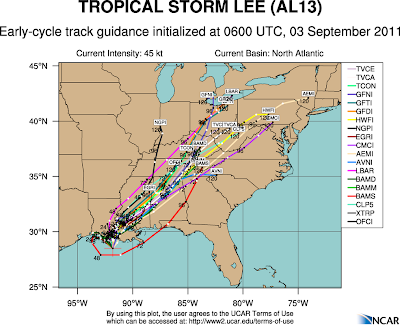
So this week we will have ample opportunity for the lots of rain. It basically could rain at any time from when you are reading this through late Wednesday. Although I'm not convinced, I believe this weekend should be nice weatherwise as Katia pulls away and slams into Nova Scotia. Here is the current guidance for Katia as per the models.
And here is the official forecast from TPC (Tropical Prediction Center). If Katia gets to 30N, 75W, then the east coast will have great concern as this will then most likely impact someplace along the US east coast DIRECTLY!
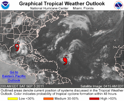
Here is where these 2 storms are located as of early Saturday morning.....
Lee will quite likely be the major player for the entire eastern half of the US as shown by the modeling on this very ominous tropical storm. Remember that Agnes (1972) was "only" a tropical storm for all but a half a day of its life! I'm not saying this is Agnes, but Lee will deliver copious amounts of rain up and down the Appalachians this week and many places WILL experience flooding once again!
Here is the progged location of both storms as per the GFS late Sunday. The major difference between the GFS and the Euro is that the Euro is about 12 hours quicker with Lee pulling northeastward. Here are the storms for Sunday morning......
And here are the locations by Tuesday evening......
And the last map I leave you with is the official forecast for Wednesday morning. I believe that Lee will be further north and east as of this time. Here we go again....with lots of rain, wind will not be as bad?
88-46; 0.657; 8.5 game lead over the Braves. This is the greatest win percentage the Phillies have ever had at this point in the season. 28 games remain this season. How many games can the Phils win in this regular season? Just goes to show what solid pitching can do AT ALL LEVELS of the game! Pound the strike zone, don't give bases on balls, don't give extra outs via errors.....baseball is a very simple game. And all of this baseball talk with the 1st week of high school and college football kicking off. What goes? Too many questions for football season in its infancy....although it does appear that Coach Chaump is creating a winner on Rutherford Road!
Have a great Labor Day Weekend....and stay dry!
Smitty
AA: It could rain and/or storm at almost any time now through Labor Day......more rain to come Tuesday-Thursday thanks to Lee. The Phillies are awesome this year!


No comments:
Post a Comment