Smitty's attempt to educate and to a much lesser extent, entertain, about all facets of life; but primarily the meteorological and the climatological aspects of the earth sciences.
Just a quick Saturday am update about what is a developing potential problem in terms of inland flooding, coastal impacts (beach erosion and flooding surge), and widespread wind damage near landfall...wherever that might be! The leading system of the remains of Gordon will set the stage for a potential large regional flooding situation in the Mid-Atlantic. Here is the total rainfall as progged by the latest Euro by Wednesday with most of this falling now through Monday am...
Here is the latest Euro operational landfall location...Hugo-like if you recall...(ouch!) The map below is valid Thursday late afternoon...
And here is the Euro ensembles...becoming more and more in agreement with each other, but certainly still quite a spread amongst the many members!
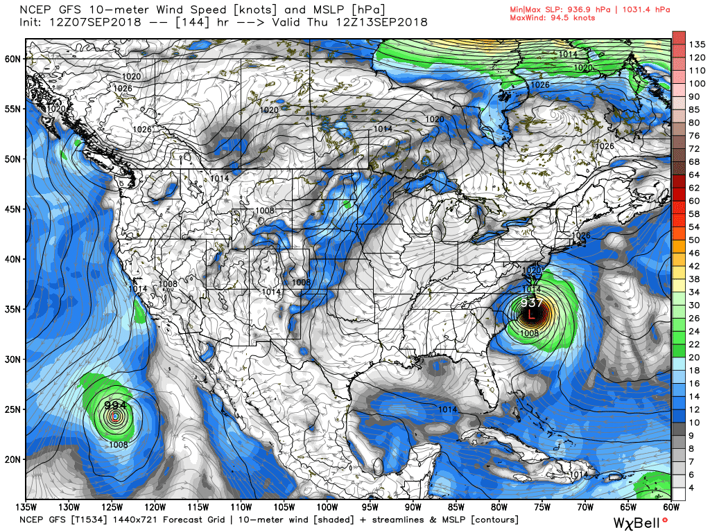
And here is the GFS operational...
And the American ensembles...clearly further north and east and hinting at more of a coastal nightmare than an inland flooding event.
Lastly, the total rainfall 10 days hence as per the Euro...15-20" of rain in the central Appalachians mountains would be a disaster for these places!
OK...I'm off to Rock Lititz to meet some friends to do just that...rock Lititz! So for my preparation, I'm going to listen to this classic as I hope you might as well! Enjoy!
Smitty
AA: Watching the rains this weekend and the path of Florence wherever she may travel! I hope not up I-81!
As most of you know, I peruse the weather and the charts on a daily basis. Some call it a hobby; others a sickness. Me, it's my passion. Example, while we've endured the heat and humidity that has been record setting the last several weeks, how about the earliest sub 30°F reading since the turn of the 20th century in International Falls, MN on Thursday morning! Spoiler alert; a sign of things to come as O Canada has been quite cool/cold the last couple of weeks! And of course I've been monitoring the Atlantic tropics and as many are aware, early to mid September is prime time. I'm now officially concerned that Florence will not disappoint. The Euro has been quite consistent with a landfall near the NC-SC border and now the GFS has joined the party...hence my concern! Let me explain...
First the Euro landfall next Thursday pm...
And the GFS landfall...a tad quicker and a bit weaker (barely!)...
Both have textbook synoptic set ups...you can see the paths based on precip totals...first the GFS...
You can see the path of Flo from the tropical Atlantic far off the coast of FLA moving WNW and moving up the spine of the Appalachians...the other heavy rain swath is from Gordon from St Louis to Bangor, Maine! The mid-Atlantic needs NO MORE RAIN this summer!
Here is the Euro's take...very similar with a disaster for the central Appalachians in terms of flooding rains! But the 2 global models are slowly beginning to agree on a solution for this tropical menace...
And before all of this, the east coast looks to be under the gun this weekend with a gale from a stalled frontal system...take a look; first winds. Those are some serious onshore winds later Sunday for the Delmarva and Jersey coasts...
And the subsequent wave heights. The map below indicates maximum wave heights for Sunday pm...that will be quite a pre-Flo pounding of the east coast and certainly NOT what the doctor ordered!
OK...for my loyal readers, I'll keep y'all posted. But I am concerned for late next week as Flo looks to mean business! Just a week out is waaaaaay toooooo far out to have much certainty, but when the GFS has now come on board with the consistent Euro, confidence is growing for a major hurricane to affect the east coast late next week sorry to say.
Enjoy this (which the Tide will most certainly be high on few occasions the next several days!) and enjoy your weekend!
Smitty
AA: Concerned that a tropical system will deliver more flooding rains to our region or at the very least within 200 miles of our area sorry to say. A 1-2" rainy weekend as well...