Saturday, October 3, 2015

Windy and Wet; Then October Glory

The winds and the rains awoke me early this October morn...not that there were no other wx factors affecting my sleep...(hint...Joaquin)...here take a last look at this storm that completely raked the Bahamas...
But he will finally and rapidly move off to the NE as per the modeling shown below...a bit better agreement than earlier in the week...don't cha think?
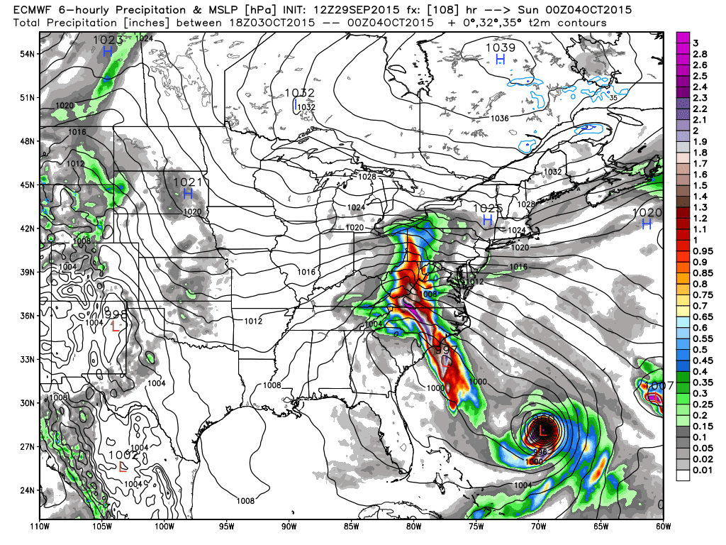
However, the indirect effect of this tropical system and the resultant pressure gradient created along the east coast are causing big seas, strong winds, and plenty of rainfall.  The monster high in SE O'Canada and the hurricane and warm oceans are quite a contrast for this early fall.  Take a look...
Thus a strong easterly component to the winds and a natural baroclinic stalled front are causing quite a ruckus along the mid-Atlantic coast.  Here is a buoy observation just off the Delmarva early this Saturday morning...that would make any winter-time nor'easter proud! (Well, maybe not the pressure...)
In terms of the front, simply look at the current temp map.  Meteo 101; draw the front!
Let's see if you passed...the current wx map and stalled front with the above temps...

Well done minions!  So once all of this "funk" passes and the upper air block dislodges, look for what will be an absolutely gorgeous fall week.  Daytime highs in the mid-upper 70s and the overnight lows a few degrees either side of 50F.  Currently for KMDT, climatology suggests 68F and 48F for the daily max and min this upcoming week.  I suspect lows will be near normal, but once the ground dries, maxes will be 10+F from the 30 year averages.  Good grass growing wx for all of you grass farmers out there!  Thursday-Friday afternoons look to be the warmest.  The only caveat; a front will be approaching later in the week and may spoil the potential warmth for Friday...

Even the American CFSv2 suggest warmth...here is the 5 day average in terms of temps for next week...
OK...enough said about the weather.  But one thing to keep in mind, especially for you late risers, make it a point to awaken pre-sunrise Thursday and Friday and do your yoga stretches towards the eastern sky allowing you to be in awe of nature's glorious display as seen below.  Venus is quite vivid in its position at present!
This could be you...or not. But either way, the clear skies will be worth the early am gander eastward!
I'm out with these parting thoughts.  The Euro this week once again proved its supremacy in the numerical modeling world; the Orioles are...well...the Orioles, I'm now rooting for the Pirates, but concerned about a one game playoff AGAIN vs the hottest NL pitcher, and I think the Dow and the equity markets in general are at their lows in the near term, thus a time to buy? (DISCLAIMER:  This is my own personal opine...seek professional investment advice!  This financial content for entertainment only! Come to think of it, all of this content is for entertainment purposes...so I hope you are all entertained to some degree.)  If you're off to any NCAA football today here in the east, stay dry and warm.  The winds of November came a tad early!

Music!  I almost forgot the music.  I've had many tell me they like the music selections better than the weather synopsis.  Hey, I can relate!  So, let's see, hmmmm, how about a classic from one of my favorite bands.  Quite apropos for this past week...Enjoy!

And enjoy the week's end!

Smitty

AA:  After a damp and breezy weekend, a beautiful week upcoming, I believe, with cool nights and warm days.  Sharpen the blades and grease the fittings my friend!


Wednesday, September 30, 2015

The Lone Wolf Euro Creating Uncertainty

The National Hurricane Center with their 5 pm update seems to take the middle ground between the global models of the 12Z GFS/GEM/JMA/UKMET and the 12Z Euro.  But the strange thing is the "official" track that is shown below is nowhere near the global models' operational runs.  The Hurricane Center is essentially splitting the difference between the "lone wolf" Euro and the remaining global model suites.  The forecasters at the Hurricane Center are hedging with their discussion stating that "confidence is low"; however, this split track solution seems to be the least likely solution at this point to me.  Either a landfall into the Carolinas/southern VA or an out to sea track are the 2 likeliest solutions...IMO.  Whether the hurricane does impact the coast or not, coastal flooding will be of major concerns as a strong easterly fetch will be prevalent throughout the weekend.  Heavy rains should also be experienced in these parts...

Take a look at the NHC cone of uncertainty...
And take a look at the spread of solutions...
If it weren't the superior Euro taking this storm out to sea, I'd be more confident of a landfalling storm, but the Euro has a history of doing very well with very challenging patterns and this is certainly one of them.  From a personal standpoint, I truly hope the Euro is correct!
And hope the GFS is not...
Truth be told, the overnight run of the Euro will either help increase the confidence of a potentially dangerous and devastating landfalling solution or lead to even more bewilderment of this impending stormy weekend.

Stay tuned...

Smitty

AA:  One of the toughest forecasts I've seen in a long time!  Here is the easy part; a wet weekend is on tap...but then again isn't that statement redundant?

Tuesday, September 29, 2015

Finally, Something to Talk About

After what has been a seemingly endless stretch of beautiful fall weather, this week will bring copious amounts of liquid sunshine and possibly a visitor from the deep tropics.  This will be quite brief and I will show you the extreme (not necessarily the outlier) solutions numerically.  First the stage is set with the late Tuesday pm water vapor loop...
Note the THREE tropical systems over the Atlantic...this really is complicating the modeling as the spread is incredible this late in the game!  Take a look...(Not liking that NGXI (Navy) model!)...as it looks to take the storm to Hudson Bay prior to it freezing for the winter!
However these systems decide to render their interaction and feedback with each other, both global models kick out a tremendous amount of precip by the end of this upcoming weekend...here is the GFS' take on total precip!

The Euro a tad further south with its bulls-eye...
The Euro takes the tropical weather out with the warmer Gulf Stream but has an inverted trough streaming moisture up along the spine of the Appalachians this weekend...
Whereas the US modeling has an ugly solution for the east coast!
Time will tell; the NHC is favoring the global solutions; namely the Euro and keeps the center of Joaquin well offshore but allows for much rain to affect the eastern seaboard.  Joaquin...lets hope this storm is not as impactful as this 2 time 20 game winning all-star MLB pitcher,  Joaquin Andujar...RIP...

OK...I'm out.  I will leave you with a favorite of mine from Jackson Browne...enjoy and stay dry!


Smitty

AA:  Lots of rain this week; might actually have a land falling tropical system Friday-Saturday time frame, but I don't believe so...just wet persists through the weekend.