Friday, March 9, 2012

Briefly Back To Reality

Those winds of change have paid central PA a visit once again...this time quickly ushering out the preview of springtime warmth we observed the last 2 days.  My attempt to get a 70ºF max on Thursday fell ONE DEGREE short as we maxed out at 69ºF....oh well!  Today, with a mix of clouds and some minimal sun, along with a stiff WNW wind, we will not get to 50ºF!  Here is the NAM's forecast maxes for today, Friday, March 9...
And the comparably coolish temps for highs on Saturday, again with a gusty wind, but possibly abating by late afternoon...in fact, Saturday appears to have a more widespread area of below normal temps for the entire NE US...
All of this is thanks to the cold front that passed through overnight and cleared PA early Friday am.  The brisk NW winds are shown here for Saturday morning, hence the 2 days of normal and below normal temps...
But rest assured that these winds will veer around to the SW by nightfall and the 2 weeks of much above normal will begin starting Sunday!  Spring Fever Warning to be sure!  Below is a map depicting departures for normal for Saturday.  Note that much of PA will be at or slightly below normal.  Also note the huge area of warmth just to our west poised to advect eastbound with the zonal flow aloft that will be moving across the continental US for the next couple of weeks.  Yes, Saturday will be cool...
...But look at Wednesday of next week!
And the following Monday!
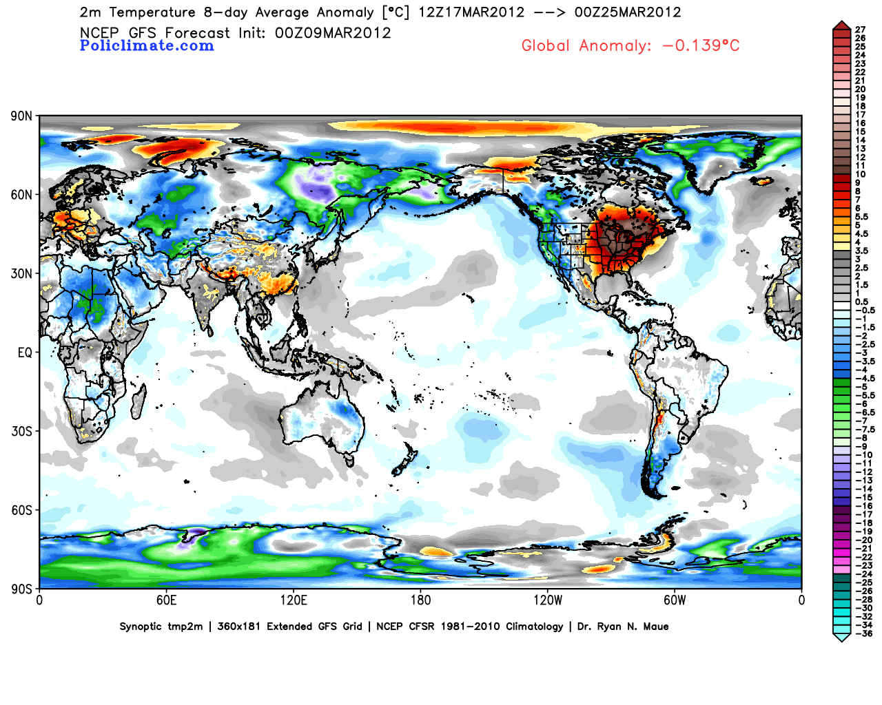
In fact, if we take a look at the 7 day running mean ending March 22, this is simply astounding for this type of departure from normal for this length of time.  This will most certainly get many people talking about the infamous "Global Warming"!  I predict on a more local note that within 2 weeks, we will notice some people who have over exposed themselves to the increasingly potent March sun and thus be sporting obvious sunburns as a result!  But the map below clearly indicates that a global analysis of the surface temps reveals a cool anomaly over the entire earth.  It's ironic that the warm areas are the populated regions of the globe...
Speaking of running means, take a look at some other running means...that being the 10, 50, and 200 day moving means of AAPL!  Wow!  Is there an end to this company's stock's incredible run?  The Law of Large Numbers suggests this exponential upward explosion must stop sooner than later...
But if you'd like to capitalize on the back of Apple products, maybe Qualcomm is the way to play this hunch.  QCOM can certainly grow and experience growth that will greatly appreciate its stock price over the next couple of years as Apple products continue to expand to the global population.  In addition, QCOM is one of the few tech stocks that actually pays a dividend, although a 1.5% DIV isn't going to create a robust stream of income...
Please remember that this author (me) nor the publisher is engaged in rendering legal, accounting, or other professional services by posting on this web site. Smitty shall not be liable for any loss of profit or any other commercial damages, including but not limited to special, incidental, consequential or other damages. As each individual situation is unique, questions relevant to personal finances and specific to the individual should be addressed to an appropriate professional (NOT ME!) to ensure that the situation has been carefully and appropriately evaluated....but I still like QCOM as a Buy!

I hope everyone enjoys their Friday and more importantly their week's end!

Smitty

AA:  A coolish couple of days followed by 2 weeks or more of above and much above normal temps!

Tuesday, March 6, 2012

Warmest & "Coldest" For Next 15 Days

Just a very brief post here to show y'all the GFS' take on what will be the warmest and the coldest days over the next 2 weeks.  We are most certainly heading into a period of above and much above normal temperature wx over the 1st to middle part of March...and likely into the latter part of March as well!  Here is the "coldest" day which is this upcoming Friday following a cold frontal passage on Thursday evening with a few showers that will be observed.  We are just a couple degrees above normal.
Here is the warmest day which is next Sunday, the day following St. Patty's Day!  That is a huge area of 20+ above normal just to the north of PA!  I am officially issuing a Spring Fever Warning that will be in effect beginning this Thursday when temps make a run at 70ºF! 
Have a good Tuesday afternoon....the last afternoon where temps will remain in the 40s and feel relatively coolish!

Smitty

AA:  Warm wx for the 1st 2 weeks of March!

Sunday, March 4, 2012

Synoptic Summation This Sunday

A cold front now to our east, which passed through yesterday midday accompanied by those winds of change,  will be followed by a trough Sunday and Monday, pulling away during Tuesday.  This will produce primarily a quick shot of colder & drier air along with some instability snow showers closer to Lake Erie.  Take a look at the visible satellite pic from yesterday.  Note the definitive line of clearing from the wx system that passed off to our SE yesterday, still wreaking havoc in the deep south.
Here is a numerical depiction of the trough at 500 mb coming through the next 24 hours...That is a vigorous trough that will spin up a storm just to our east...Note all of the energy accompanying this trough; no wonder the wx was so feisty the other day!
Here is the ocean storm, just another miss in the winter of 2011-12!
The trough will flatten quickly by Wednesday and a ridge of high pressure will develop over the east...
A surface high pressure will set up over the western Atlantic Ocean, a Bermuda High (although just a tad north) if you will, and will keep Harrisburg, along with the vast majority of the east coast, dry and allow it to become increasingly mild for the middle to end of next week!  Note the SW flow around the 1036 mb high pressure!
Another strong front will be working its way across the mid-section of the country as seen on the map above and below producing what is likely to be another round of volatile wx (although its waaaaay tooooo early to determine is the severity will be as ferocious and heartless) this time focused more on the Arklotex region...
...and those winds of change will once again be ominously breathing down our backs by next weekend once again!  But a large area of high pressure (1040 mb) will dominate the northeast and once again provide what at first will be chilly wx, but moderate into something more springlike a week from now into early the following week...
All eyes will be watching what now is a new feature on the numerical modeling; the infamous cut-off low.  The old adage is well known in the field; cut-off low is a weatherman's woe!  That thing just sits and spins over TX for several days as depicted by the GFS!
For us, the flow "over the top" will mean moderating temps until that upper low decides to do its thing!  You can see the Euro keeps the upper low back over the deserts of the SW whereas the GFS has the cut-off reflection over TX.  Both the Euro and the GFS overwhelm the lower 48 with mild springlike air for next week, so consistent temps in the 60s look easy for next week...maybe touching 70ºF by Wednesday the 14th!
Look at the NAEFS probabilities for next week's temps!  Wow!  Spring in its full glory across the lower 48 while Alaska can't shake this winter!

OK...there is a Sunday Summary for y'all!  How I see the wx over the next 2 weeks or so.  I know many of you are not too much into the tech stuff seeing that we did not grow up with it, but I for one think Twitter is very cool!  You can quickly get info and data within minutes...good for being "on-the-go" to and fro.  So if you are so inclined, sign up for a Twitter account and check it out.  And if you do, you can follow various aspects of society that interest you...including many dandy agencies and their designees that keep followers informed of happenings and events in their niche.  I opine on Twitter as well and obviously often do so about upcoming or impending wx.  So if you follow @SmittysSynopsis on Twitter, you'll get some quick info on weather data and my oft times intransigent thoughts on other matters of the heart...if you so desire...
Enjoy your Sunday!

Smitty

AA:  Roller coaster ride in temps this week...becoming consistently warmer for much of next week!