Smitty's attempt to educate and to a much lesser extent, entertain, about all facets of life; but primarily the meteorological and the climatological aspects of the earth sciences.
Although most of you are fully aware of the mild weather of recent days and weeks, I am now in strong belief that this Sunday we will likely set a record max for KMDT. The record is 63°F set in 1948. 63°F seems like a reasonable target given the synoptic set-up. Please allow me to set the stage...First the 500 mb heights from normal; quite mild aloft for us here in PA Sunday!
Next, the 850 mb temperature anomaly. Remember, these are the temps up about 1 mile above the surface of the earth here in PA. 15°C is about ~30°F above normal for this time of year! Cookin'...
Here is the very strong jet supporting warm air advection into these parts as well...note that our air originates "Where the stars at night are big and bright.... deep in the heart of Texas"!
This 5 day 850 mb anomaly ending the 15th of December does not bode well for my skiing compadres in the north country!
With just even a little downsloping WNW wind, we should top out in the mid 60s barring any appreciable precip between now and Sunday. The Euro "ties" us; I believe the mighty Euro is underdone by 2-4°F. We will see what we will see...I can't believe I'm rooting on a record max for December! Man, I must be getting old!
By the way, just for kicks and giggles and to graphically depict how mild it truly has been...here is the last 45 days...Wow! Note the Great Salt Lake as an isle or mild!
But rest assured, the pattern WILL CHANGE sooner rather than later and this mild weather will be long forgotten once January rolls around...but that is a different story for a different day! As for today, I leave y'all with this ditty...enjoy your Beautiful "Fun-day Sunday Day"!
And enjoy your mid-week!
Smitty
AA: Continued mild with record warmth "likely?" this Sunday. Saturday will also be nice but the record max is a bit too high for our set up I believe. Enjoy those young-ins!
I know it's been awhile since I last opined about the weather, but an Arctic intrusion is likely to rudely remind us all that the 3 coldest months of the year are just around the corner. I simply wanted to give y'all a "heads-up" as to the situation as I haven't really heard too much scuttlebutt about such cold. Remember, it's been quite warm the last several weeks as you know. Here is the warmth depicted graphically:
Yes...it has been warm. But all of that will change beginning this weekend. It will be a step down process with a reinforcing shot of truly modified arctic air invading Sunday afternoon. The polar air coming Friday and Saturday will be chilly but the real slap will be Monday! Here is Saturday morning's temperature anomaly...
Note what lurks in the plains and Rockies...That will arrive Sunday afternoon but will really be felt Monday compared to averages!
However, another warm spell will give relief quickly from the cold come the few days following Thanksgiving...However, look what is back in the Dakotas and high plains drifting our way!
Although the cold will not affect us here in the east as much as the impact will be felt further west, compared to what we've experienced to this point in November, this will feel COLD! The graphic below is from the Euro, a 7 day average for the 1st 7 days of December. That is a very cold continental US 7 day map! Keep in mind, this is in °C!
So...the bearer of bad news? Well, not so much as I believe December for us here in PA will end up a degree or so either side of normal...but again considering how warm both October and November have been, it will feel quite cold to us. I will also leave you with another type of "Cold Shot" many of you might enjoy...I know I do!
Stevie Ray Vaughn...enjoy!
And enjoy your upcoming Thanksgiving week and remember to give thanks in some small way for all of which with we are blessed...
Smitty
AA: A step down to colder weather the next couple of weeks. Sunday-Monday will be quite chilly. Then a moderation before some serious chill will invade the 1st week of December. Walks will be brisk in the lot; but they will be!
The winds and the rains awoke me early this October morn...not that there were no other wx factors affecting my sleep...(hint...Joaquin)...here take a last look at this storm that completely raked the Bahamas...
But he will finally and rapidly move off to the NE as per the modeling shown below...a bit better agreement than earlier in the week...don't cha think?
However, the indirect effect of this tropical system and the resultant pressure gradient created along the east coast are causing big seas, strong winds, and plenty of rainfall. The monster high in SE O'Canada and the hurricane and warm oceans are quite a contrast for this early fall. Take a look...
Thus a strong easterly component to the winds and a natural baroclinic stalled front are causing quite a ruckus along the mid-Atlantic coast. Here is a buoy observation just off the Delmarva early this Saturday morning...that would make any winter-time nor'easter proud! (Well, maybe not the pressure...)
In terms of the front, simply look at the current temp map. Meteo 101; draw the front!
Let's see if you passed...the current wx map and stalled front with the above temps...
Well done minions! So once all of this "funk" passes and the upper air block dislodges, look for what will be an absolutely gorgeous fall week. Daytime highs in the mid-upper 70s and the overnight lows a few degrees either side of 50F. Currently for KMDT, climatology suggests 68F and 48F for the daily max and min this upcoming week. I suspect lows will be near normal, but once the ground dries, maxes will be 10+F from the 30 year averages. Good grass growing wx for all of you grass farmers out there! Thursday-Friday afternoons look to be the warmest. The only caveat; a front will be approaching later in the week and may spoil the potential warmth for Friday...
Even the American CFSv2 suggest warmth...here is the 5 day average in terms of temps for next week...
OK...enough said about the weather. But one thing to keep in mind, especially for you late risers, make it a point to awaken pre-sunrise Thursday and Friday and do your yoga stretches towards the eastern sky allowing you to be in awe of nature's glorious display as seen below. Venus is quite vivid in its position at present!
This could be you...or not. But either way, the clear skies will be worth the early am gander eastward!
I'm out with these parting thoughts. The Euro this week once again proved its supremacy in the numerical modeling world; the Orioles are...well...the Orioles, I'm now rooting for the Pirates, but concerned about a one game playoff AGAIN vs the hottest NL pitcher, and I think the Dow and the equity markets in general are at their lows in the near term, thus a time to buy? (DISCLAIMER: This is my own personal opine...seek professional investment advice! This financial content for entertainment only! Come to think of it, all of this content is for entertainment purposes...so I hope you are all entertained to some degree.) If you're off to any NCAA football today here in the east, stay dry and warm. The winds of November came a tad early!
Music! I almost forgot the music. I've had many tell me they like the music selections better than the weather synopsis. Hey, I can relate! So, let's see, hmmmm, how about a classic from one of my favorite bands. Quite apropos for this past week...Enjoy!
And enjoy the week's end!
Smitty
AA: After a damp and breezy weekend, a beautiful week upcoming, I believe, with cool nights and warm days. Sharpen the blades and grease the fittings my friend!
The National Hurricane Center with their 5 pm update seems to take the middle ground between the global models of the 12Z GFS/GEM/JMA/UKMET and the 12Z Euro. But the strange thing is the "official" track that is shown below is nowhere near the global models' operational runs. The Hurricane Center is essentially splitting the difference between the "lone wolf" Euro and the remaining global model suites. The forecasters at the Hurricane Center are hedging with their discussion stating that "confidence is low"; however, this split track solution seems to be the least likely solution at this point to me. Either a landfall into the Carolinas/southern VA or an out to sea track are the 2 likeliest solutions...IMO. Whether the hurricane does impact the coast or not, coastal flooding will be of major concerns as a strong easterly fetch will be prevalent throughout the weekend. Heavy rains should also be experienced in these parts...
Take a look at the NHC cone of uncertainty...
And take a look at the spread of solutions...
If it weren't the superior Euro taking this storm out to sea, I'd be more confident of a landfalling storm, but the Euro has a history of doing very well with very challenging patterns and this is certainly one of them. From a personal standpoint, I truly hope the Euro is correct!
And hope the GFS is not...
Truth be told, the overnight run of the Euro will either help increase the confidence of a potentially dangerous and devastating landfalling solution or lead to even more bewilderment of this impending stormy weekend.
Stay tuned...
Smitty
AA: One of the toughest forecasts I've seen in a long time! Here is the easy part; a wet weekend is on tap...but then again isn't that statement redundant?
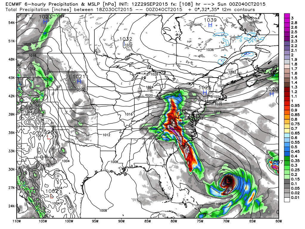
After what has been a seemingly endless stretch of beautiful fall weather, this week will bring copious amounts of liquid sunshine and possibly a visitor from the deep tropics. This will be quite brief and I will show you the extreme (not necessarily the outlier) solutions numerically. First the stage is set with the late Tuesday pm water vapor loop...
Note the THREE tropical systems over the Atlantic...this really is complicating the modeling as the spread is incredible this late in the game! Take a look...(Not liking that NGXI (Navy) model!)...as it looks to take the storm to Hudson Bay prior to it freezing for the winter!
However these systems decide to render their interaction and feedback with each other, both global models kick out a tremendous amount of precip by the end of this upcoming weekend...here is the GFS' take on total precip!
The Euro a tad further south with its bulls-eye...
The Euro takes the tropical weather out with the warmer Gulf Stream but has an inverted trough streaming moisture up along the spine of the Appalachians this weekend...
Whereas the US modeling has an ugly solution for the east coast!
Time will tell; the NHC is favoring the global solutions; namely the Euro and keeps the center of Joaquin well offshore but allows for much rain to affect the eastern seaboard. Joaquin...lets hope this storm is not as impactful as this 2 time 20 game winning all-star MLB pitcher, Joaquin Andujar...RIP...
OK...I'm out. I will leave you with a favorite of mine from Jackson Browne...enjoy and stay dry!
Smitty
AA: Lots of rain this week; might actually have a land falling tropical system Friday-Saturday time frame, but I don't believe so...just wet persists through the weekend.
Well, the 1st week of school did not disappoint. The heat and humidity refused to acquiesce for the entire week, although many numerical models for Friday scoffed at 90+! In fact, my wife's astute observations of weather noted that KMDT was the hottest in PA this Friday afternoon. Take a look ...
Another blast from the furnace then slapped me when I entered the oven known as my Subaru. When I opened the vehicle which was sitting on the blacktop paved surface all afternoon to head for the land of milk and honey; wow, more heat! Prior to my commute home, I struck up adult conversation. Always love to shoot the breeze with my beloved brethren! Otherwise I seldom see them ... many topics were discussed; MLB, HVAC, NFL, nutritional ketosis ... just to name a few ... it helped to air out the car ... but to no avail! It was hot and seemingly getting hotter! Building towering cumulus all around, but not a drop here at our humble abode. Crispy and wilted would be some descriptive adjectives to describe our property's vegetation ... fairly typical for early fall; after this wet spring and early summer, kind of ironic! Here is a look at the last 7 days of precipitation ... New England and our area of PA have had 0 precip!
After what should be a nice weekend in terms of both heat and slightly lower humidity, the heat and humidity and the endless summer will return in spades as schools reopen next week. The map below shows the temp anomalies for the next 5 days ...
... Thanks to a heat pump in the mid-levels of the atmosphere. Note the isobars from Mexico to Quebec ... and all of the heat and humidity along the way conveyor with it!
But by the end of next week, the pattern will change as a strong jet disturbance digs into the northern plains and likely ushers in an air mass change on / about Friday. In addition, I believe the jet stream disturbance to be a "winter-like" event where one goes up strong into the lakes, through the lakes and a secondary storm spins up along the coastal plain. The Euro kinda hints at that. The map below is valid for early next weekend and shows a near "phase" of the 500 mb jet. Take a look ...
And here is the depiction surface; note the weak L over Baltimore ... likely to verify since I'll be supporting our faltering Orioles next weekend vs the best team in MLB! Oh well ...
And with this trough comes an air mass change; but still above average for us ...yet much cooler in the plains.
OK ... off to bed. It was a good week! I teach, I listen, I communicate with colleagues and friends, I exercised in a slightly different manner, changed my diet ever so discretely, ... (for the better) ..., and I listened to (believe it or not) even more KA music. So I will leave you with a tune that frankly I'm wishing for as to give our little crispy portion of the earth some relief. Sorry Timmy, but we now need some liquid sunshine; It has been too dry...
And chances are it will rain in Baltimore since we are there next weekend for seemingly meaningless AL games. I was hoping these were previews of the ALCS just like last year ... oh well ...
I hope everyone enjoys their labors this Labor Day weekend. If I were younger, I would have inserted Rush's "Working Man" here; google it if you are so inclined! An excellent rock and roll tune! Here, stop, ...I will help...copy and paste...worth your 8 minutes!
AA: Not totallty feeling it tonight. Looking forward to true am duty....and the discussions that accompany. Think Thursday to Saturday next week COULD be wet! Keeps you hoping into the month of October! But not my Os or your Sox...
Now being guilty of how most view weather and climate, I should back up the title with data from the past. However, perception is often more important than reality. And the perception to which I allude is that it always seems to get hot once school begins in September! This year will be no different. Just take a look at how our August has been so far to date...
And more closer to the current time; how about just the last 10 days. Trust me, the 5+ºC anomaly is welcomed by many in the nation's mid-section at this time of year!
But all of this is about to change. A large upper ridge is building over the eastern part of North America and will remain entrenched for what I believe will be well into the month of September. With that said, heat and humidity will be able to build from the Mississippi east and prolong summer up until the equinox...gut feeling at this point! Take a look at the 500 mb ridge over downeast O Canada for the start of September. The jet stream will be well north of our latitude here in the eastern portion of North America. You can see the "blue" anomaly in Texas; the model is sniffing out a potential tropical system which at this time of year is always a potential proverbial "fly in the ointment"!
And that ridge holds through Labor Day! There's not too much difference between the 2 maps although more tropical mischief is showing up in the SE USA potentially but these tropical systems are difficult for global models to detect this far in advance.
And speaking of tropical troubles, here is the latest from the NHC (National Hurricane Center) as to the path and strength of Erika...
It now appears as if it will be a major rainmaker for the state of Florida as it passes over the Keys as a minimal tropical storm and its remnants will deliver much precip to the SE USA. Here is a graphic showing precip over the next 5 days as per the Euro...
So, one must always be wary of the tropics at this time of year. But lets look at how the temps are forecast to be into September...first for the entire month:
And let's see how we achieve this. I will show graphics of temperature anomalies for 10 day periods starting with this weekend through Labor day:
Next, the middle of the month...
And lastly, the cooling that is seen as the pattern breaks down by month's end...
So as usual, I'll leave you with a little ditty that relates in some way to the above topic. In this case, the beginning of school and the end of summer; however, the weather will not cooperate with the latter at least until mid-September! Enjoy this folksy effort from The White Stripes...
And enjoy your week's end...
Smitty
AA: Warm to hot and mostly dry for us here in PA for the start of September. Likely our warmest stretch of weather all summer when compared to the "normals"! Nice parking lot weather!
Although the resolution of the graphic is not the best, yes...the Phillies did SWEEP the Marlins with their walk-off win on Sunday! And that would be a correct answer to be sure as to what is wrong with the above graphic! However, being the wx guy that I am, I was alluding to the last 2 games listed with a wx related postponement in both San Diego and Anaheim! That's correct...it never rains in California...especially in July. In fact for the Angels, it was their 1st rainout in 2 decades dating back to 1995. Additionally, the Angels in their 55 years in SOCAL have only lost 16 games to rain; all but 2 being during the months of either September or April! All of this rain over the past weekend compliments of what was tropical storm Delores. The 0.36" of rain that LA received on Saturday was by far a record for July!
Here is how the NWS Doppler radar appeared during the widespread rainfall for the desert SW...
And this "blob" of moisture continues to move across the Great Basin of the western USA...note the areal flood watches and localized flood warning near Las Vegas which again is very rare for mid-summer.
Here is the water vapor imagery as of this morning...also note the huge cluster of storms over the mid-section of our country as well...
And this "blob" of moisture and atmospheric energy in the form of deep moisture and the associated latent heat should enhance some storminess over the Rockies and into the Plains the next couple of days...here is a look at the precipitable water anomalies approaching 2-3 stand deviations above the norms across the 4 corners spreading into the southern plains...of course the big blob of moisture remains in the atmosphere off the coast of CA!
And here is how this manifests itself in terms of western storminess...
OK...OK...enough of the west Smitty...but what about us here in PA? Well, the next graphic I show you is somewhat ironic and more telling as to how much cooling is again on the move for midweek. Here is a 5 day average of temps that included yesterdays observed heat and the forecasted heat for today...
And the coolest 5 day stretch I could find centered on Wednesday afternoon with the map below...
As for you lovers of summer and you beach bums...well, next week, the heat will return along with the moderate to high humidity...quite frankly...typical late July wx...
As an aside..."Late July" is an awesome product...sorry I digress...(and no, I am not trying to monetize this blog)...
So with that I'm off to throw some kettle-bells around, row a bit, and brush Ziggy and Zola. (Our 2 dogs get crazy when they get brushed; its really quite humorous!) I'll be listening to the 70s whilst I move about with this ditty possibly popping up on XM...I hope you enjoy as much as I will...
Enjoy the week...and the break from heat and humidity Wed-Friday!
Smitty
AA: Two rare west coast rainouts yesterday...so your BoSox play 2 today! As for us, hot & humid today with storms breaking the heat and humidity Tuesday afternoon. Nice wx for Wed-Friday...enjoy it! Big Orioles-Yankees series this week! Let's Go Os!