Saturday, June 24, 2017

Train, Train

I'm up early this Saturday morning thanks to a train!  But not what most think of when they hear the word "train".  I'm talking about training cells of convection!  The rain has been pounding down for a few hours here at my humble abode and has awakened me from a deep slumber.  The sound of large drops striking our sunroom's glass is actually quite loud.  Hence, my awakening!  Of course, I scoped the radar and from there, here I sit studying the weather...again!  Here is how training showers depict on a computer model for precip output...note the train is a'rollin from West-by-God-smile-when-you say-it-Virginia to New York City...
But by the time when many of you peruse this, the train will be long gone!  And a glorious air mass from our neighbors to the north will be invading our country.  The strongest part of the anomalous cooling will be to our west; however, we here in PA will benefit with cooler and much drier air for the next several days.  Note the below normal temps in the Dakotas, MN, and WI for Saturday...
By Tuesday, the coolest of the summer temps will arrive here in PA...take a look...
Not only is it cool, the air will be very dry!  Here is a map I seldom show; precipitable water in a column of air.  This is a metric of essentially how much water could be squeezed out of the air if all of the moisture was to precipitate out.  In the winter, PW is quite low; in the summer, it has the potential to be quite high, especially in the tropical air masses.  Look at how low the PWats are for Wednesday am...but also note the stream of moisture advecting northward from the western Gulf to Lake Winnepeg!
So by next weekend, the heat and humidity both return to us here in PA...
 
In fact, the map above shows the warmth returning by Thursday!  And by next Saturday...well...here ya go...back in the "yuckies, muckies, and stickies"...note the anomalous humidity as per the "PWats" training directly over our lovely commonwealth!  Also note the 2 areas the model believes storms will be likely; just west of my son in STL and over God's Country in northern PA.  (Might be some blown out streams Goldy next weekend...?!)
 
As for July...here is a quick look as per the CFSv2...but don't get too excited as this is the first time it has shown such a "cool" signal to the middle part of the country into the east...too much to show, but the last several runs of the climate model was showing widespread warmth across the CONUS...but is that surprising?  Even the modeling has a warm bias in these politically charged times of global warming!  Ha!

OK...enough!  I need another coffee with my MCT.  Now, some of you might be wondering...probably not...but MCT?  Medium Chain Triglyceride...another story for another day!  Enjoy your weekend and the the invading train of cool to roll through our state this upcoming week!

And enjoy this throwback to when I was a kid!

Smitty

AA:  After the overnight rain that brought up to two inches in some parts of our area, a much drier and cooler air mass will pay us a visit for the next 5 days!  Highs in the upper 70s to low 80s with lows in the mid 50s!  I think Wed am, there will be temps in the 40s in south central PA!  But not at KMDT as that is the official reporting station and we wouldn't want such cool temps being officially recorded!  Good mowing and landscaping weather to be sure!  And Yokes...good paver laying as well! 

Thursday, June 22, 2017

Consistent Cindy

I'm doing back to back posts to show you how consistent the models are or are not from 18-24 hours ago.  I will show you the current outputs from the 3 global models and the one tighter grid model that I showed you yesterday.  Model consistency is something that leads to forecasting confidence.  For me, it's but a hobby; for many, it's their bread and butter!  In addition for this weather thing being my hobby and since I've been doing this weather watching thing all of my life since I was a "crumb-snatcher" (an affectionate term often used by my wife), when a plume of tropical moisture surges northward towards a diving trough from Canada, be aware of heavy downpours and training convection here in the Mid-Atlantic!  I've seen it many times before and will see it many times going forward.  So, here are the total precip outputs all valid for Saturday morning...the same time frame I showed you yesterday.

First the Euro...
Next the GFS...
And the O'Canadian...note the "dome" over the PA turnpike from Breezewood to Bucks County!
Lastly the higher resolution NAM...
I believe the message here is expect some fairly robust precip in these parts (much needed I might add) and there is a possibility, or more like a probability, that locations a mere 50-100 miles apart will see a vast difference in rainfall totals.  That is to be expected with convective, tropical systems.  Here is the most recent outputs from the storm tracks of the center of lowest pressure (Cindy's remnants) from numerous models...
And the top view of how Cindy and her associated deep moisture looked early this Thursday morning...the center of lowest pressure located just northeast of Houston...
So from observing the models and numerous past similar synoptic set-ups atmospherically, I expect Friday to be a "rain-out" with on/off heavy showers and even a few thundershowers with the bulk of the rain departing by mid-morning Saturday...by the way, this Sunday looks to be a "Chamber of Commerce kinda day!  Enjoy!

And enjoy this tune about what's happened to some extent the last several hours down in eastern Texas and other parts of the deep south...

Smitty

AA:  Warm and increasing humidity on Thursday sets the stage for a washout for Friday with about 1-2" of rain by Saturday morning.  Front pushes through and much drier air for Sunday through the bulk of next week...

Wednesday, June 21, 2017

Here Comes Cindy

By now, most of y'all are fully aware of the impending landfall of TS Cindy somewhere near the TX-LA border along the Gulf of Mexico.  But I've seen these plumes of deep tropical moisture translate north and east once they move towards more northern latitudes.  Since yesterday, the amounts of precip on all models have increased for our region.  But the exact location has been wavering back-forth between a I-80 to a US 40 line.  About the geographical middle ground between those 2 east-west roadways is KMDT.  Right now, the guidance would suggest about 0.75" of rain should fall, mostly during the daylight hours of Friday...here are the various models...

First the Euro...
Next the GFS...
And the final global model I'll share is the O'Canadian...
And the smaller gridded NAM...
So, it looks as if there will be some rain, but just how much is still a roll of the dice as of now.  Gut feeling deep moisture with approaching height falls that may lead to record coolness early next week, I believe we are looking at at least 0.50" with 1.5" not out of the question.  Time will tell...Here are all of the plots as of today with the track of the storm...
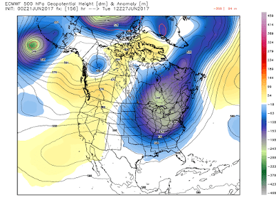
And here is how deep this trough will be at its greatest deviation from norms next week (Tuesday)...that is quite the trough for this time of year!
OK...back to more computer work here at school.  I just took my lunch to study this system and share some of the numerical guidance with my faithful readers (after a beautiful stroll outside in this glorious sunshine)!  So, with that said, I'll leave y'all with a Merle Haggard classic...enjoy!
And enjoy this beautiful afternoon!

Smitty