It is now becoming painfully obvious that the tropical troubles that are presently in the Gulf will phase with the strongly digging trough and create a powerful storm for our mid-week period. I do not want to down play this event as gusty winds with fully foliated trees growing in saturated soil is a recipe for widespread uproots! The present satellite pic from Sunday afternoon shows the gathering tropical storm in the Gulf.
Note the clear skies to the north of the disturbed wx west of Cuba and northeast of the Yucatan. But this heat and humidity will fuel the digging shortwave and spin up one heck of a storm (988 mb or lower) that will begin to affect our wx by Tuesday afternoon. Here is the surface map for Tuesday afternoon.
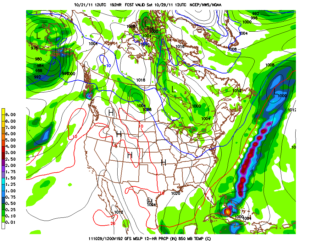
And then 12 hours later during the midday period of Wednesday! The dome will be closed in Milwaukee or the fans will be bundled up in St. Louis for the start of the World Series Wednesday evening! The blue line you see is the 0C line at a mile. It will be cold to be sure in either location with the obligatory accompanying bone chilling breezes!
By Friday, the storm is pulling away up into the maritimes and the cold will be whisked into our region on strong and gusty NW winds. Friday night football this upcoming week will be a cold evening to be sure!
Here is a better picture of the cold 850 mb temps. From this point, I'd say temps in the low 40s at kickoff and falling into the upper 30s by the end of the game for Friday Night Lights!
The storm that will be developing for this week is compliments of a deep 500 mb trough that yesterday I believed would hold back and bundle some of its energy to "phase" more with the tropical energy and sure enough, it does seem that the GFS wants to do this. The UKMET actually has an even deeper east coast bomb with greater phasing of the heat, humidity, and the upper air energy! I still believe the bundling of the upper energy is still not completely being handled by the modeling at this point, but it is better than yesterday as we get closer to the actual event!

And as I said yesterday, this trough will not lock in, but is transient and by Sunday, temps will be moderating, but another deep trough is on the docket for the subsequent week as October will end up being slightly below normal temperature wise for the month. That is a trough with an even colder source region of air. Follow the isobars (black lines) up from PA and look where they originate! This is a true shot of Arctic air if this model verifies for the last week of October! Brrrrr...

But it is October! And a precursor of things to come for the next several months of dark days, colder wx, and political bickering and grandstanding as we are about to reach the 1 year point to the next presidential election. Hopefully we have just one last "lame duck" year of incompetence running the executive branch of government. But who will be the challenging ticket to oust the present occupant of the White House? Will it be Romney-Christie? How about Cain-Gingrich? Whomever it might be, they will have quite a mess to mop up.....and there is no doubt about that either!
Enjoy your Monday!
Smitty
AA: Strong storm to develop mid-week followed by some cold weather for the end of the week. After a brief warm-up the end of this weekend, next week will also be cold and getting colder it appears. Just over one year until another presidential election! Can you believe that!?!