Smitty's attempt to educate and to a much lesser extent, entertain, about all facets of life; but primarily the meteorological and the climatological aspects of the earth sciences.
You know the news cannot be very good when the word "historical" is used twice within the same month! As many of you are fully aware, the Mississippi River drains a large region of the US. It is the 3rd largest river drainage system in the world; only the Amazon and the Congo drain a greater land area! Old Muddy drains 41 percent of the 48 contiguous United States, including all or part of 31 states and 2 Canadian provinces. The excess rains of the mid-Mississippi Valley and the Ohio Valley during march and April are now coming home to roost! That is one awfully large funnel collecting precip to flow past "Red Stick" and New Orleans.
Extreme flooding along the Mississippi in 1927 moved congress to pass to legislation a year later authorizing construction of levees, floodways, and a variety of other landscape modifications to control the flow of the Mississippi River essentially to prevent a more severe flood scenario. One such engineering design was to create spillways along the levee system to relieve pressure further downstream on the levees and reduce the possibility of a catastrophic flood. The release of the water upstream back in the 1930s flooded primarily farmland and actually enriched the soil "naturally" for subsequent agricultural years. However, today, there are numerous homes and businesses that lie in that same area due to the development of the flood plain. The graphic below shows how opening the the Morganza Floodway back in 1973 inundated the adjacent land areas as compared to a non-flooded view.
Below is the non-flooded view a few years later. Red is essentially farmland and vegetation in this older landsat image:
Plans by the governor of LA (no that is not Tommy Lasorda all of you baseball junkies) is to open the floodway and inundate the areas north of Baton Rouge. This would divert the flow of the river south and west of the major population centers in central and southern LA. Although tremendous hardships will ensue, this option seems to be the lesser of 2 evils. The map below shows the potential flooding that awaits southern LA by opening the floodways.
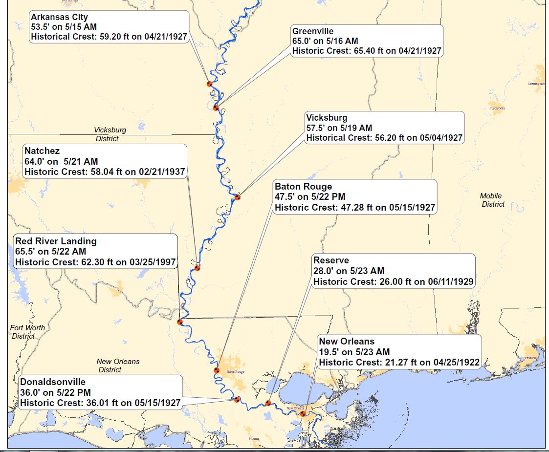
This map below shows just how "historical" this flood really is. The crests are astounding! Nearly 3 million acres of farmland devoted to corn, soy, wheat, and cotton are not arable this year due to the extreme flooding. As a result, therein lies another soft commodity play for those of you who enjoy to monitor futures contacts on such things. As for me, I believe I'll try to beat the favorite in the upcoming Preakness next week at Hi-Ho Pimilco!
For those of you who this really interests, the video clip below which will take 3 minutes of your life, gives a very informational overview of the levee systems and the like as developed by the US Army Corp of Engineers:
As for our local weather, rain will be present in all of the next several days to some degree. By Thursday, the gardens and lawns will have received ~2.00 inches of nature's nectar as per the MREFs as shown below. It will be a dreary time, but how appropriate as we enter the local election primary this Tuesday.
Just in case some of you are still confused about the Tommy Lasorda comment, many of us including yours truly have this infatuation of the sport of baseball. When you see the abbreviation "LA", one automatically thinks of the Dodgers and their glory days being ruled by Lasorda. But the governor of LA, Boddy Jindal, who some have touted as the next US president, has about as much chance of becoming president as my favorite baseball celebrity juxtaposed with one of the better managers baseball has ever seen!
Have a great week's end!
Smitty
AA: Info on Mississippi River Flooding and a rainy, wet week forthcoming for our area.
Once upon a mid-May dreary, while I pondered, weak and weary,
Over many a quaint and curious volume of 700 mb charts,
While I nodded, nearly napping, suddenly there came a tapping,
As of some one gently rapping, rapping about a blocking -NAO.....yo!
"'Tis some upper air unwanted visitor," I muttered, "tapping at my central PA-door Only this, and nothing more." With great regards to EA Poe, and sincere apologies for butchering his prose, I can't think of a better opener to use to describe how dreary this upcoming week may become. Once the higher dewpoint air invades by Saturday, the sun will be but a distant memory of this glorious past week. As I show below using the 700 mb forecasts from the GFS, there will be an abundance of moisture at the 2 mile point in the atmosphere. This is a very important level in which to analyze for cloud formation and precipitation as once air saturates at this level, especially in the warmer season, precip tends to make it to the earth in the saturated column. Although we may not be looking at a copious amount of precip, we could end up with nearly 2+inches by next Thursday evening. Some places will get hit hard with showers while others will dodge the heaviest of the rains. The rainiest periods look to be Sat evening-Monday morning and then again Wed morning through Thursday afternoon. The maps below show the forcasted 700 mb level for the upcoming week; dark green would support rain while light green would support thick overcast.
Friday:
Saturday:
Sunday:
Monday:
Tuesday:
Wednesday:
Thursday:
Looking even farther into the merry month of May, the GFS actually develops a tropical depression/storm in the Gulf of Mexico around the 22nd of the month and its remnant energy moves across northern Florida and up along the east coast of the US; a pretty wild solution but certainly not out of the question......stay tuned!
I do hope that you enjoyed this nice string of dry days in our region (it hasn't rained in earnest since last Wednesday although it rained in Etters last Saturday with a gusty shower!). Now we pay the piper...a string of mostly cloudy days with rain a possibility at almost anytime through the upcoming week!
Enjoy your Friday!
Smitty
AA: Dry for Friday's Mid-Penns and City Island district baseball match-up but potentially wet for Saturday's events. Then rain could occur basically anytime right through next Thursday.
During this month of May there will be a unique morning show offered free of charge thanks to all of the naked eye planets with the exception of Saturn. You will need a good clear view of the eastern horizon...and the use of binoculars with a wide field of view would greatly enhance your success at locating Mars and especially Mercury. As I just came in from the outdoors and noting the crispness of the air and the cloud-free sky, tonight and tomorrow morning would be as good as any look for your favorite celestial body. In fact, most of this week will be adequately clear for some good spring stargazing! The graphic below shows Tuesday morning's planetary configuration. By the end of the month, a waning crescent moon will enter the planetary gathering as Jupiter climbs higher into the heavens!
I've also linked a NASA video below describing this planetary alignment during this merry month of May! Enjoy!
Meteorology and Astronomy....it doesn't get any better than this......unless you need your car washed and "One-Drop-Jere's" tennis teams can take care of your needs this Saturday. Or you have a desire to view some high school baseball at the fine facility down at City Island this Friday evening. Or you fancy some accomplished high school athletes in their track and field events at Landis Field this weekend. Or simply look up to the cloud free, "wx event lull" sky and enjoy the show from our planetary neighbors!
Smitty
AA: A rewarding glimpse of the sky during the pre-dawn hours this month as 4 planets are aligned in close proximity!
Just a very quick update to let everyone know that this blocking pattern that we're in is keeping the rain just out to our west. The map below shows the accumulated precip through Saturday morning....note the lack of shading here in SE PA. It is unfortunate that much of the rainfall this week will fall on the already saturated ground of the Mississippi and Ohio Valleys and the water will add more insult to the devastating floods in the lower Miss Valley!
But also just to let you know that once Saturday rolls around, rain should be falling in earnest by midday and although it is just a bit too far into the misty distant future, once the precip begins, a prolonged period of cool, damp weather will be in the cards for our region. The graphic below is the 6-10 forecast from Climate Prediction Center of NOAA.
I was informed that my notifications to some of you are getting "Barracuded"! Not sure what to say....maybe it is a conspiracy to keep my wx opinions from being used in a persistent and a pervasive manner to the regular weather folk....like the terminology....eh? Or the e-mail program doesn't see eye to eye with g-mail. Either way....just look at the "Blogger" site to see if my life has remained in the doldrums and I really don't have a life outside of weather and school! Or, put my e-mail address on the "safe" list....if you are so inclined to do so.
By the way, by placing that vehicle above, it reminded me to inform everyone to support "One-Drop-Jere" and his tennis teams' car wash this Saturday!
Have a good Tuesday!
Smitty
AA: Nice precip free week followed by rain arriving just in time for the week end and it will last into the middle of next week!