Smitty's attempt to educate and to a much lesser extent, entertain, about all facets of life; but primarily the meteorological and the climatological aspects of the earth sciences.
Since Tuesday, all of the modeling has been fairly consistent with this island of cold (and snow) in an otherwise sea of mild weather we are currently experiencing. It just so happens that a rather vigorous jet that will ultimately usher in our record warmth for the Tuesday-Wednesday time frame will also have a precursor runaway streak that will produce a moderate snow event here in southern PA during Saturday evening. Now I am aware that many have argued that the recent warmth will inhibit snow accumulations; however, what I am seeing is a rather quick moving heavy hitter of ++snowfall rates during prime-time Saturday evening...and that is my concern for my loyal readers. As many of you know, I'll likely be asleep when the heaviest snows are falling, but I know many will want to be out and about...just sayin' to be alert. I'll let some maps do more talking...
I'll start with the regional model for snow accumulations; usually the best predictor at this time range IMHO. The NAM is indicating a Route 30 special and has been for many runs in a row. KMDT will likely measure and inch either side of 4"...
Why such a robust quick hitter of snow? Glad you asked! The graphic below shows the energy in the mid-levels of the atmosphere this evening. Hone in on the focused energy from WVA through southern PA. The area near that concentrated upward motion will produce the heaviest axis of snowfall and more importantly snowfall rates. With that said, again the global models have been fairly consistent in recent runs with that mid-level vorticity and therefore a moderate accumulating snow is likely is these parts. Take a gander....
But that same jet will buckle even more in a SW to NE fashion in response to the vortex in northern O Canada moving west and sending arctic chill into the Rockies and northern plains. Here is the forecasted position of our upcoming mid-week jet...
A very large and anomalous area of Bermuda high pressure is flexing its muscle at all levels of the atmosphere...
This will produce a large area of much above normal temps for both Tuesday...
...and Wednesday while the cold is relegated to the western US. Record warmth is likely from our area north and east through New England both Tuesday and Wednesday.
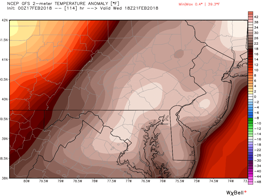
In fact, here is a close-up of our region's temperature anomalies for Wednesday. The graphic indicates our area to have nearly a 40ºF above normal max for the day! Normal maxes are 42ºF both Tuesday and Wednesday. Record maxes are 72ºF (1930) and 71ºF (1997) for Tuesday and Wednesday respectively. I believe this just may activate a Vitamin D watch in these parts; at the very least, a Spring Fever Warning to be sure!
So I will leave it at that. I do not want to rain on anyone's parade and show you the long term model run for temps for March! Did I even say that? Different story for a different day...But here is a nice little ditty with "spring" and "summer" hidden in the lyrics. Take a listen!
Alright, some unique weather events for everyone within the next 5 days...so enjoy nature's weather offerings and enjoy your President's Day week's end!
Smitty
AA: Saturday evening snow followed by a solid warm-up culminating (ending) with record warmth both Tuesday and Wednesday I do believe. Plenty of water in the soil now for the grass to quickly awaken come spring. Many crocus bulbs should be popping this week!
Very short post...I'm not believing what I'm seeing...Euro by Sunday morning...
Often the global models correct further north and west...I'm hoping waaaaay N and W! For those of you wondering and asking...well here is the GFS...
Clearly the Euro has a tad stronger wave of low pressure bending the arctic front that WILL push through Friday night-Saturday...big ?? is will that stronger Euro wave develop? I'm hoping not, but I've seen this many times before....and as for the longer term...winter is NOT over...as I now believe the beginning to middle of March looks rather wintry...ouch!
OK...enough from Fat Tuesday's synopsis...I've been studying music much more than the weather this evening, but when I saw that Euro output, I felt compelled to share....and I'll share my favorite tune I jammed to this evening...I hope you like as much as I like...by the way, 9 straight days of accumulating snows in sweet home Chicago! Tied a record from 2009 and 1902 I believe...awesome!
Out...
Smitty
AA: Thought we were out of the woods....? Not so sure now...? Great jam...worth listening to and your kids will be dancing by the end!