Thursday, December 26, 2013

Twas The Night After Christmas...


...and all through the @SmittysSynopsis (Twitter handle) house,
Not a creature was stirring, not even a mouse (possibly due to the exorbitant feral cat population in our area!)
No stockings were hung by our chimney this year
We were simply thankful for all we hold dear.
The children (Ziggy and Zola) were nestled & curled on the bed
While visions of feral pussy cats danced in their heads.
And Kay with her nightshirt, and I in my PJs
Had just settled down since there were no more sun's rays.
When over on my nightstand there laid my iPad
My insomnia kicked in, I looked to see what the Euro had.
Away to my desktop, I flew like a flash
Opened up Google Chrome, to see if the GFS was trash.
The waning crescent moon was rising in the southeast
Provided enough light to see my kids outside; those beasts!
When what to my wondering eyes should appear,
But the latest Euro run, providing PA with a moderate snow to end the year!
OK...I'll stop there with my apologies to Clement Clarke Moore...

But I will show the the GFS has a slightly more phased solution, but doesn't hold the cold over the eastern sections of PA like the Euro and thus we end up with a moderate to possibly heavy rain event to end the year.  

Which is correct?  It's too early to tell.  But my concern for receiving an appreciable snowfall will wane like our present moon if we don't see larger arctic high build across southern O Canada during this time frame.  The old adage, predict the high; predict the snow works very well in these types of scenarios especially at this time of year!  The Euro has a high, but it is not very strong as low pressure seems to easily slice its way into New England.  Certainly, interior locations especially in the north country will start to re-develop their snow pack, but it may be too warm here for any appreciable accumulations.
Here is the GFS in terms of surface pressures for the same time period...it is a nice synoptic set up with the exception of a BIG BURLY HIGH in Quebec.  Personally, I'd like to see it a few mb higher...this will once again be a close call for snow/rain and the dividing line will be close to our area.  Some things never change!

So we will begin to hear of a coastal development for early next week...so I'll try my best to keep y'all updated on the latest modeling updates and expert forecasters thoughts and ideas.  One thing I believe is becoming more and more certain is some serious cold will develop once this storm passes.  Here is the eastern trough setting up for later next week...
That is a cold 500 mb map for January...and it appears January will be on the colder than normal side for us if you believe the CFSv2...

I hope everyone had a very Merry Christmas Day, and continue to enjoy the Christmastide celebrations for the next week or so... 

Smitty

AA:  Monitoring the possibility of a coastal storm developing late in the weekend into early next week...followed by some fairly robust cold.  Enjoy this Christmastide with your young family!

Wednesday, December 25, 2013

Merry Christmas!

First off...Merry Christmas to everyone!  The most joyous of the holidays, Christmas often marks the beginning of the worst winter can offer in these parts.  However, our winter weather actually came quite early to us arriving in time for Turkey Day and lasting right through the middle of the December.  But what actually had been a rather impressive snow pack is all but a soggy memory now as record warmth invaded the eastern US!  Look at the last 60 days (prior to the warm-up) across North America in terms of temps as compared to the 30 year average...
And...yes...that warm up was one for the record books all up and down the east coast!  Here at KMDT, we actually smashed our Dec 22 record between 2:30 am and 3 am when the mercury shot up 9ºF on a strong south wind!  I walked outside just to feel the warmth and humidity directly delivered to us compliments of that powerful southerly wind!  Note the warmth from the 20th on...and note the persistent cold prior!
In fact, here is what December looks like temperature-wise across the country to this point...the last several days really "tempered" the cold bias for the month...note the strong west Atlantic ridge and warmth over the SE USA as compared to the rest of the country...this is what help create a storm track that help create our brief snow pack.  Also note the reloading cold in south central O Canada!

And, for what it is worth, that cold held tough for our neighbors to the north as one of the worst ice storms in recent years pummeled the southern province of Ontario over the weekend cutting power to hundreds of thousands in and around the city of Toronto.  Note how the rain and the warm temps wiped out much of the snow pack in the east...

CURRENT:

DECEMBER 15:
This snow covered earth is is key to the upcoming couple of weeks as air masses that will be directly discharged from the arctic WILL NOT moderate too much as they advect south and east in what is forecast to be quite a trough in the upper atmosphere over the next several weeks!  Many meteorological signs are pointing to a period of cold that will bring hardship to those who simply are unable to deal with these brutal outbreaks of cold!  The graphic below shows the last 3 runs of the CFS v2 in terms of surface temps for the month of January.  That is a classic ridge west, cold east stormy wx pattern.  And the model is also sniffing out a very deep snow cover in northern New England!

Here is how the upper air forecast appears for the New Year's Eve celebrations...bundle up!

And ALL global models have a storm spinning up the coast for roughly early next week.  It is way too early to pinpoint details, but a coastal storm will be lurking in these parts sometime early next week.  Here is O Canada's run for the last Sunday of 2013.
And then the hounds of winter will really be unleashed...look at that arctic front crossing PA just in time for the 1st weekend of 2014!
Here are the top 10 analogs for the forecasted upper air heights for next week as per the GFS.  There are some cold periods that show up and and that is a classic cross polar and stormy looking signature!
OK...I've rambled enough.  I believe you get the idea that is appears this upcoming January will be a cold one for us here in the eastern part of the US.  Now that we are past the winter solstice, the days will begrudgingly lengthen...but the old adage "As the days lengthen, winter's chill strengthens" will hold true this January.  I hope you enjoyed the furnace resting warmth of the past few days as the furnace will be cranking into the first several weeks into the New Year!  In fact, I'll leave y'all with this James Taylor rendition of an old hymn...
In the bleak midwinter, frosty wind made moan,
Earth stood hard as iron, water like a stone;
Snow had fallen, snow on snow, snow on snow,
In the bleak midwinter, long ago.

Our God, Heaven cannot hold Him, nor earth sustain;
Heaven and earth shall flee away when He comes to reign.
In the bleak midwinter a stable place sufficed
The Lord God Almighty, Jesus Christ.

Enough for Him, whom cherubim, worship night and day,
Breastful of milk, and a mangerful of hay;
Enough for Him, whom angels fall before,
The ox and ass and camel which adore.

Angels and archangels may have gathered there,
Cherubim and seraphim thronged the air;
But His mother only, in her maiden bliss,
Worshipped the beloved with a kiss.

What can I give Him, poor as I am?
If I were a shepherd, I would bring a lamb;
If I were a Wise Man, I would do my part;
Yet what I can I give Him: give my heart.


Merry Christmas to y'all! Enjoy your family and friends!  For unto you is born this day...a savior for all people...who is Christ the Lord!

Smitty

AA:  After this impressive warm spell, cold will invade once again, especially in earnest next week with some serious cold on the move towards the US and these parts!  Merry Christmas my friend!

Wednesday, December 4, 2013

No Major Storm...Just An Arctic Boundary

And that said boundary will serve as an atmospheric slope to make relatively warm and humid air overrun the front of much colder, denser, and drier air creating bouts of snow, icing, and even pockets of liquid rain when the precip is not very heavy.  The next 10 days after a relatively "warm" Thursday will be quite cold and damp in these parts with snow and ice accumulations continually piling up from time to time.  The Euro has even suggested that a sub zero day is possible later next week...but I'm not buying that...yet.  This implies the model has a relatively moderate snow and ice pack on the surface in these parts for such serious cold to manifest itself this early in the season.  But the cold is something to behold...look at these impressive 24 temp changes in the high plains!
...and the current apparent temps across the northern plains.  That cold will slowly ooze south and east towards us by Saturday.  It will be moderated to be sure from its present state, but the cold mass will advect towards us unrelentingly!  Here are the current "real-feel" temps...
Near 80 in north TX today.  Not so much tomorrow...the Big D will not know what hit them overnight!  The Big D is gonna experience the Big Chill and I'm not talking the 1983 flick!  I liked...FYI.
And that air will be working its way towards us as well...take a look...1st here is 7am Friday.
And then 7am Saturday...
Finally Sunday at 7am...
What the map above doesn't show, but the upper levels are quite cold as well.  Thus, when the air starts to push from the southern US later on Sunday, much frozen precip will break out all along the Ohio Valley and up into PA.  Just where the axis of heaviest precip sets up is a real question.  But the Euro has been rock solid in suggesting that ample frozen precip will fall in these parts by Monday pm and once again later in the week as more warm air tries to erode the arctic air that is in place.  Suffice to say, winter will be felt in these parts through next week...and of that I am fairly sure.
Take a look at this meteogram from the Euro for the next 10 days...enjoy the warmth of Thursday kids!  3+ days of below freezing temps later next week following a lot of frozen slop and gooply glop!  At the very least, many places across the US in the northern states will start getting into the Christmas feel by simply looking outside at nature's frosting...

One thing to me that certainly indicates that it is coming on Christmas is the short days we are now experiencing...sunset at 4:45 pm after a 7:15 sunrise in these parts...and with that low sun angle, it is very difficult to mix and erode any of these low hanging clouds that have obscured our sky.  Joni Mitchell sings about other observations she remembered indicating that Christmas was a few short weeks away...I hope you enjoy as much as I.


And as always, thanks for humoring me by reading my take on this wonderful natural world in which we are but such a small part!  Everyday, I become even more in awe at how this natural world operates!

Enjoy your end of the work week...and by the way, that OK-OK State game might be the new college "Ice Bowl"!  Temps in the low teens at early kickoff!  Snow on the sidelines and in the stands...could be fun!  Them Sooners and Cowboys won't know what hit them!
Gotta run...

Smitty

AA:  Mild Thursday, but then some serious cold will slowly bleed into these parts and then hang tough for the next week or so.  A few bouts of frozen precip to boot along with some liquid sunshine. Ellsbury a Yankee...how 'bout that?

Thursday, November 21, 2013

Very Interesting!

For those of you my age and a tad bit older...you'll remember Artie Johnson's famous quotes...
...and I don't think he was studying the Euro snow output for the last several days over our neck of the woods!  The axis of heaviest snow is essentially aligned along the I-81 corridor!  How very convenient to show that this might be the heaviest snowfall for most of us experienced this early in the season!  It is only Thanksgiving after all!
One thing that seems to be nearing certainty is that this will most decidedly be a disruptive storm for many in the northeast quadrant of the US over what is oft proclaimed to be the busiest travel day of the year! Note where the GFS places its axis of heaviest snowfall...um...in the hill country of the south lands!  Veeeeeerrrrryyyy interesting......but Stoooopid! (I think)...?

Here's the O Canadian...if you care...it too keeps the axis south of PA...but I'm not so sure...and I'll let y'all know why!  One thing for sure, cold will be ample to support frozen precip if the storm decides to venture up the coast...
You see, with the ocean temps at their warmest of the cold season, this should pump the SE ridge making the storm push up along the coast and seek its natural baroclinicity between the ocean and the land. The oceans are warm and thus a poleward bulge is likely keeping this storm a "hugger" as opposed to a "fish storm"!  Note the anomalous warmth in the Gulf and along the east coast....
Hey...y'all know my bias and that is for winter being long and strong!  But whatever happens...happens.  I just think next week could remind people more of celebrating Christmas as opposed to Thanksgiving! But both are obviously worth celebrating, no matter the weather!  But having a memorable snowstorm on Thanksgiving is one of those "extreme" events that is undoubtedly caused by the disruption of the natural weather patterns by humans...ie...GLOBAL WARMING! Sorry I digress...Here is one of my more memorable Thanksgiving winter events...what a bonehead!
Leon...don't Lett the game get away!  Oh well!  How 'bout them Cowboys?   In terms of updates about this upcoming winter wx situation, I may not be able to opine as oft as I like as I will be playing around in "Cajun Country"...hopefully singing and dancing to something that might sound like this...
Although that version is a bit tame for my blood!  But I will say I was disappointed to some extent when I saw the operational temps come in at this for Sunday...man that is chilly for "Cajun Country"!  Oh well...it is what it is!
Enjoy your Friday everyone...and your potential Thanksgiving snow event!

Smitty

AA:  Here's hoping you and your young family have an awesome Thanksgiving holiday time and enjoy the season leading to Christmas.  As for the wx, I think it will be mid-winter cold with a good chance of plowable snow for Wed-Thursday!  Ye-haw!


Monday, November 18, 2013

Quite The Blow!

The storm that ripped through the Mid-Mississippi Valley and the Great Lakes region is doing exactly what mid-latitude lows are supposed to do; thoroughly mix the atmosphere top to bottom or bottom to top and left to right or right to left...whichever your preference.  The earth is in this constant IMPOSSIBLE battle to balance its heat.  The transition seasons of autumn and spring are when the fight is often greatest.  Thus, severe wx outbreaks as observed yesterday in the Midwest are the sensible wx result of this imbalance...take a look...84 tornadoes reported November 17, 2013!
Now the gale center is located northeast of Lake Superior on the south shores of James Bay with pressures down to 968 mb!

And here is how the IR topside view appears...
Our crystal clear skies and dew points in the mid 20s are a result of air getting pulled into this system from the high plains and central Rockies! High pressure is progged to rule the roost the next several days as it ridges east over NY...
And after a storm system works its way from the southern plains NNE into the lower Lakes on Saturday...

...a very large and COLD arctic high will move across the lower 48 the 1st part of Thanksgiving week.  If the model verifies below, Sunday will be quite cold and blustery across PA with lake effect snows widespread across the lakes including the favorite parts of PA.


But then, later on nearer Turkey Day, storminess could be evident across much of the eastern USA disrupting travel either by plains, train, or automobile....here is the Euro's map for Thanksgiving morn...
that low pressure would've caused ample precip as it moved from the gulf coast to its progged position...and with the arctic high retreating, much of the precip has the likelihood of being in some type of frozen forms once to our latitude!

In fact, the Euro thinks turkey week will be quite cold in these parts...for a 5 day average, that is a cold map!
Alright...gotta run.  I'll try to update later this week...but if you are so inclines, between 5am-6am this week under what should be quite clear skies, you might want to try to spot Comet ISON low in the eastern sky?  This is a neat interactive...

http://www.solarsystemscope.com/ison/

You won't see this...

...but if you wait until ISON heads back out to outer reaches of the solar system, you might get a better naked eye glimpse...here is a good map over the 1st 2 weeks of December...
So give it a shot; albeit a cold shot I do believe....to try to spot the comet...

Smitty

AA:  Nice wx through end of week then another frontal passage for the later part of the weekend.  Quite cold early next week with the potential for wintry precip by Thanksgiving. When it's clear, look east early in the am to try to spot a comet.


Saturday, November 16, 2013

If You Like Your Wx Pattern...

...You can keep your wx pattern, period!  Here is November as we completed half of the month in terms of temps...
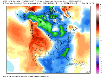
Here is the CFSv2 forecast for the remainder of the month...
For us here in PA, the remainder of the month looks like 2nd verse, same as the 1st!  But there are some changes spinning around the roulette wheel of wx! Note how AK is now forecast to get cold and look at how that cold axis is focused towards the eastern lower 48.  Also note how Greenland is turning a bit warmer as before it was cold.  This is known in the biz as a "blocky" pattern, or one that will suppress and slow air masses across the lower latitudes of the contiguous states.  If all of this comes to fruition, then the first part of December looks to be quite cold...and possibly stormy!  The CFS seems to agree...here are the temp anomalies through the 1st 10 days of December...

Now if we can get any precip to attack these "Arctic Highs" that keep coming south and east, we are looking for the potential of a White Christmas.  I'm not rushing the season, but I've had several already ask about such potential...I'd just like to remind y'all that a "White" Christmas is not a frequent occurrence here in the sub-tropics of southern PA!  Take a look...we are roughly a 1 in 4 chance...

But the probability of yet another rotund arctic high paying us a visit is rather high as the WPC shows on its latest maps!
If this map verifies, then Wednesday morning will be quite chilly...no...COLD...in these parts! All indications are that this air mass will be ever so slightly "warmer" than the last; however, with a 1032 mb monster sitting right over PA for the pre-dawn hours would mean the possibility of near record cold by sunrise...just sayin'...The Euro says cold mid-week to be sure!  But it does keep the coldest portion of the air mass over O Canada...
Here are the temps for 1 mile up come later Tuesday evening...
This air will be ushered in compliments of that robust area of higher pressure as shown above.  The predicted rainfall later Sunday night into early Monday morning will mark the cold frontal passage announcing the arrival of the colder air once again...or in the GFS' words, If you like your current wx pattern, you can keep your current wx pattern, period!  The map below depicts 4 hours of radar ending daybreak Monday morning.  
So by Tuesday afternoon, the GFS suggests the surface map to look something like this...a large area of high pressure controlling the eastern part of the USA.  Note that it is really only slightly above normal in terms of its forecasted pressure; (~1.5 SD above norms)...
But a larger and stronger area of High Pressure will be coming for the following weekend, essentially assuring another colder than normal period!  Interesting feature is obvious in the map above (tropical system), but in the map below, a more subtle look to the map is showing low pressure developing in the western Gulf and must be monitored for "Fowl" wx for Turkey Week.  
OK...enough said for now.  But I will leave y'all with this...I was once again very much entertained by the sport of high school football last evening and often look back at a game and try to understand how or why?  The East High tailback carried the ball 30 times once again for 170 yds...but in all honesty, I didn't think he had that many carries!  East High won that game in all aspects last night except in 2 very important categories; special teams (that 70 yd punt by the Dallastown punter was a "game-changer" as was the PI call on the "fake punt fade" play to the DT gunner in my opinion) and the ultimate category...THE SCORE! Nonetheless, the Panthers had a fine season, playing well into November when the majority of teams completed their season's 2 weeks back.  It's just tough to lose a game with only 16 seconds remaining...congrats to both Cats, but most definitely East High.
So who will come out of District 3 AAAA?  An Eagle or a Wildcat, or a Falcon, or a Bulldog?  That's a prediction I'll let y'all make.  I'll stick with the cold wx for the remainder of November!

Enjoy your week's end...and as always...thanks for reading!

Smitty

AA:  It's been cold so far this November...and more of the same is coming!  My favorite time of the year for high school football...but it is just a little cold at times!