Smitty's attempt to educate and to a much lesser extent, entertain, about all facets of life; but primarily the meteorological and the climatological aspects of the earth sciences.
Since the weather this Saturday will be one of the top 10 weather days of all year (Sunny and ~80ºF), I felt compelled to share just a bit about the annular eclipse that will be occurring over the Pacific rim this weekend. I will also expound in just a very brief manner what the oscillating Pacific Ocean might imply for our weather this upcoming winter season...but before I go there, look at the 500 mb pattern for late Saturday...controlled by high pressure! That trough (or weakness in the upper air pattern) to our south does spell trouble however for early to middle of next week.
Here is the total rainfall forecasted by the GFS for the period Monday through Wednesday...I believe that the "blue" area over VA will be a bit further north and over us here in southern PA. But we will see what we will see....
But there is no denying the wx for this Saturday and Sunday as high pressure rules the roost! That low off the Carolina must be watched for early next week as the high pressure will fade off to the ENE...
But as for this upcoming solar extravaganza, our fellow citizenry of the western part of the US will be treated to an annular eclipse as the sun sets this Sunday. An annular eclipse is one where the moon is unable to total cover the sun as its distance is just too far from earth and thus appears too small in terms of its angular size in the sky. Kinda ironic since 2 weeks ago a "Super Moon" was being hyped as it was closest to the earth in conjunction with full moon phase!
Earthlings, as a result, will see something that looks like this if they are in the path of "annularity"...
And here is that path where prime-time viewing can occur in our country just prior to sunset...Winslow, AZ might be a nice place to catch this celestial event...at least that's what Jackson Browne alluded to in his 1972 song here authored and sung most famously by Glenn Frey and The Eagles!
Follow spaceweather.com for excellent updates or any other link from there to view this eclipse via the world wide web, and what observers in the path are willing to share!
As for our upcoming El Nino, here is a forecast of the Sea Surface Temps (SST) and the on coming El Nino, albeit a weak signal, for the next several months.
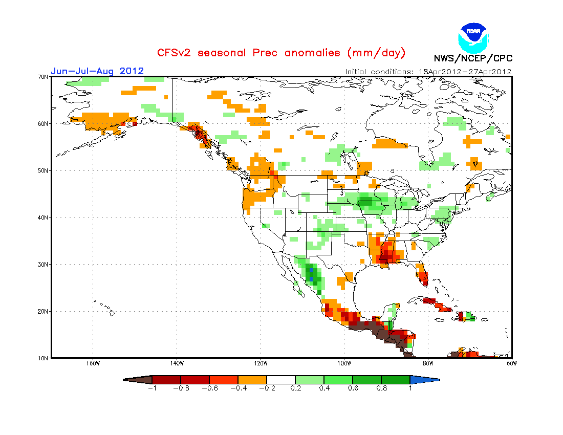
Based on the Climate Forecast System, here is what the upcoming summer might hold based primarily on the these oscillations in the Pacific ocean, THE PRIME DRIVER OF THE EARTH'S WEATHER PATTERNS AND NOT MAN! Basically a weak signal for warm in the western US and no real clear signal in the east...
And here is precip...a weak wet signal over PA with slightly stronger signal over the upper Mississippi Valley and dry in the lower Mississippi Valley and south FL....
This is all interesting to me...maybe not so much to y'all, but I find it fascinating that these climate models are actually on the improve as more input from the Pacific Oscillations (El Nino/La Nina) are being introduced!
Enough for now...listen to the Eagles' "Take It Easy" thinking you are in Winslow, AZ watching an annular eclipse this Sunday evening!
Enjoy this gorgeous weekend!
Smitty
AA: Nice weather this weekend! Solar eclipse out west. Summer looks "normal", maybe slightly wet here in PA based strictly off the latest climate modeling.
Just a very quick post this morning concerning our recent rains this past week. As I'm sure many of you observed, the sky yesterday afternoon had "convection" written all over it in the form of those beautiful towering cumulus clouds...some of which evolved into Cb. As I checked my rain gauge before the sky completely darken last evening around 9 pm, glancing to the east, I observed lightning flashes off into the distance. Many of you had a nice couple of days of rain, but our annual precip deficit remains at -1.60" for the year at KMDT. Here take a look...focus on the middle graph for rainfall/melted precip. The deficit is essentially from March 1 as we were at "normal" on that date. Also notice the coolness of May with the top temperature graph...
Here is a map of the Susquehanna watershed over the past 72 hours...that's 3 days for you Yokes! The heaviest of the rain fell over the northern part of the basin...however, Yokes would swear that the orange speck is right over his house where the deficit has been erased in qualitative, not quantitative opinion!
And with that rainfall comes the rise in the Susquehanna River. Here is the flow increase over the past 7 days! Quite a turnabout from the beginning of the month...don't cha think? Might even have a few blowouts up north Goldy!
As for our ground water levels, a similar pattern can be observed compliments of the recent rains!
The next several days, once we get past the last threat of storms this afternoon between 4-8 pm as a dying front passes through central PA, will feature beautiful springtime wx with sunny skies, light to moderate breezes, and temps in the low to mid 70s. By Sunday, we might be around 80ºF once again. Look at that 1024 mb high right over NE PA for Friday morn...she's a beauty!
As will be Bodemeister standing in the Winner's Circle at Pimlico after the 137th running of the Preakness Stakes!
Have a great Wednesday....
Smitty
AA: Slight chance of a shower or t-shower this pm between say 4-8 pm...then beautiful wx through the week's end! Follow me on Twitter...I've been putting out quick updates there...its just faster and easier and more efficient...watch out as my team is starting to wake up!