Smitty's attempt to educate and to a much lesser extent, entertain, about all facets of life; but primarily the meteorological and the climatological aspects of the earth sciences.
First, I found this picture of the tornado path in southern and western Mass last week. You can clearly see the path of destruction from this visible satellite image. When I saw Sturbridge, MA, it reminds me when I was once driving home from Fenway when the traffic backup was so bad exiting the Mass Pike they simply opened all the toll gates to allow the flow of traffic resume....who said there is no such thing as a free ride!
Second, there is a major hurricane near North America, but it is absolutely no threat to land. This hurricane is west of Acapulco, MEX by 200+ miles and moving west by northwest. it will continue to weaken over the weekend from a Cat 3 on the Saffir-Simpson Scale. The 2 graphics below show both the satellite imagery and the 2nd shows the projected path.
The white area is referred to as the cone of uncertainty. The red to the right shows the approximate location of Acapulco, MEX. I did that for you Mick.
Third, Texas, especially west TX, is in an extreme drought. As you can see, this is simply ugly and the commodity prices of beef and pork bellies will most certainly be affected by this extreme drought. This is nowhere close to the great dust bowl times of the 1930s. I might try to pull up some data supporting the fact that the 1930s were a real hardship in both financial depression and precipitation deficits! It was a real trying time in the great plains.
Well....I found this graphic and it shows that the greatest amount of max records in central Iowa were clearly in the 1930s. Dry land breeds heat and heat breeds drought.....positive feedback! It just keeps heating and heating.
And while it is hot and dry in Texas and the nasty fires rage in eastern AZ, they are still skiing in the Wasatch Mtns of Utah and hope to be until July 4! The graphic below shows the 200-300% snow pack still in the central Rockies. And with such a late summer, there will be less time for snow melt and before you know it, fresh snowfall will be adding to the snow pack. Don't tell Al Gore, but this is how glaciation progresses!
Lastly, my watch for Jeter continues as he approaches 3,000 career hits. With his lone safety last evening, he is now 10 away from 3,000! And that is for you "A"!
Have a great celebration of yet another academic year completed.....and with apologies to Pink Floyd...."shorter of breath, and one day closer to retirement!"
Enjoy the week's end!
Smitty
AA: A variety of meteorological musings. And DJ is only 10 away from 3,000!
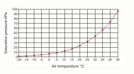
We've heard many people say that over the years....and they most certainly have a point. Recently, the dewpoints have been hovering around 70F. That is very muggy air for us here in PA. Frankly, however, when the air temp is above 85F, it is quite capable of having much higher dewpoints. In fact, the air "wants" to have a higher vapor partial pressure of water in it. The graph below clearly illustrates that as the ambient air temperature increases, the partial pressure of water vapor can also increase.
Many times people ask me why we don't get huge snowfalls like we can get heavy rain storms in the warmer months. Well, if one scrutinizes the graph above, when the winter precip events roll around, there is much less water vapor for the air to work with at colder temps than in the warm season when the partial pressures of water vapor can be and are often substantially higher. There is more than 4 times the water vapor in saturated air at 86 F than there is at 32 F! And sometimes people say it is too cold to snow. Well, there is a little bit of truth to that since as temps get increasingly colder, the air's capacity for water vapor partial pressure approaches 0 hPa. Hence, the gelid continent of Antarctica is a colossal COLD desert!
I show y'all that just to help cool you off from this early season heat. The most uncomfortable combo of heat and humidity I observed today was 93 F and dewpoint of 73 F! The data below shows quite an uncomfortable day, that's quite sweltering....
The graphic below shows the uncomfortable dewpoints Thursday afternoon all the way up into New England. The yellows, greens, and blues are very comfortable dewpoints.
A look at the numerical guidance for Sunday evening; much more comfortable air in terms of humidity and appreciably lower dewpoints! It will feel very refreshing.
Peering even further into the future, the American and the European models are somewhat at odds. The Euro shown below has a decidedly warmer solution than the the American GFS as there is a weak ridge over PA from a zonal flow across most of the country.
Whereas the GFS has a deeper trough with a pronounced NW flow leading to a much cooler and drier atmospheric solution. Which is correct? It's difficult to get any insights on this as of this evening. I'm rooting for the GFS!
You know, this early season heat is certainly what most fans of the sport would refer to as "baseball weather". I'm not a big New York Yankee fan, but I for one am rooting for Derek Jeter on his quest to join the greats of the game. Jeter has been nothing but an ambassador for the game. This future hall of famer deserves all the accolades he'll receive when he reaches the 3,000 hit milestone. My only question; will he attain this record by the summer solstice on June 21 at 17:16 UTC? Only time will tell.
Enjoy your week's end!
Smitty
AA: Unsettled weekend as front lies nearby. Drier by Sunday afternoon/evening and becoming much more comfortable through next week. Even for a Red Sox fan; Jeter is the man!
Yes...and it's hot today for that matter. In fact, the record max for today of 96ºF (set in 1999 at KMDT) is in danger. That being said, tomorrow could actually be a degree or 2 higher before the cold front approaches from the north and west. The map below shows the sharp temperature gradient that will be over PA thanks to our air from the Canucks.
That front is well depicted on the modeling with both the wind shift as noted by the streamlines and the showers and thunderstorms that will accompany the frontal passage. First shown below is the potential for some beneficial rains to assist in withdrawal symptoms I'm observing in my friend Ronnie as he has not had to mow in the last couple of days. You see this addictive behavior in so many avenues of life, but lawn mowers anonymous meetings cannot be found at many locations in our area!
The map below shows the surface winds and the frontal boundary between the air masses is clearly represented by the streamlines.
Once the front passes Thursday night and Friday morning, it will not venture too far south of our area leading to an increased potential for showers and thundershowers for this upcoming weekend. Enough of a push south however will lead to cooler temps for Friday so NO HEATWAVE this time of 3 days of 90ºF+ temps, but try to tell anyone that today or Thursday and they'll look at you like you have 3 eyes! Here is the guidance for max temps for Friday afternoon.
The map below is the GFS ensembles for next week at this time in terms of the "normal" max temps for next Wednesday. As you can see, once this heat is pushed south and west down over Big D, we will be looking at temps averaging below normal for a few days. What this map doesn't show is that some of the modeling does take tropical storm Arlene's remnants and creates a nice storm for the mid-Atlantic and points north. If that scenario would verify, Ronnie would once again be mowing every other day through June!
In closing, the picture below is from Rocky Mountain National Park in central CO. Hindered by the most late-season snow in the last quarter century, Rocky Mountain National Park crews finally opened Trail Ridge Road for the season 2 mornings ago. This opening is more than a week after the traditional Memorial Day weekend opening. The roadway is the highest continuous paved road in the United States, climbing to 12,183 feet and connects the towns of Estes Park and Grand Lake. The road was officially closed last Oct. 29, 2010 for the winter season. Why didn't the road open on Memorial day Weekend? There was simply too much late-season snow, according to RMNP officials. Before this week's late opening, the latest the road had reopened in the past 20 years was June 4, 1994. The latest the road has ever opened was June 26, 1943.
And just to keep you in the cold season spirit, the video below shows snow on Mauna Kea; home to some of the world's largest optical telescopes. Snow is a relatively common occurrence in January in the peaks of the Big Island, but not in June! It's a sure sign of more of this thing called global warming!
Off to grade final exams from my attendees. Have a good Wednesday!
Smitty
AA: Hot through Thursday, then showers/storms Thursday night into Friday. Cooler with some showers over the weekend. Much cooler by middle of next week.
It appears as if the the heat pump high will slowly migrate and build northeast ushering into PA another bout of unseasonably hot weather for early summer. The high tide of this heat slosh will be Thursday when temps should easily surpass 90ºF and possibly hit the mid 90s for max temps. The map below shows the GFS ensembles as a 7 day mean max temp vs the "normal" temps for the same 7 day period. Clearly, the northeast is modeled to be much above normal while the northern plains and the Rockies are guided to be much below normal.
However, by next Tuesday, it appears that cooler air will invade the US squashing the heat ridge farther south and west and allowing the northeast to cool off back to near normal temps.
With Thursday likely to be the hottest day of the week with a max of 95ºF or so, a front pressing from the northwest could get a bit lively. It is not out of the question for storms to boil up any time Tuesday or Wednesday afternoon, however, it appears with the cold front moving southeast, focused convection will occurred Thursday afternoon into early Friday when the front clears the state. The map below depicts the 850 mb temps with the advancing front over the nw portion of PA Thursday afternoon.
The surface map for Saturday morning, should it verify, will deliver another gorgeous day for PA and points north bathing in much cooler and drier Canadian air thanks to that large blue H over southeast O Canada.
I'm still watching for Arlene to develop in the Caribbean and the Hurricane Center in Miami has upgraded the likelihood of the cloud mass shown below to become a tropical named stormed within the next 48 hours. You can clearly see the circulation of the deep convection just a bit east of where it was this weekend.
I feel a bit out of the weather loop due to a busy weekend that included nocturnal thunderstorms, surprising midday mesoscale convective systems, in depth research & discussions of the Illinois River Watershed, the significance of significant figures, seized horizontal wind generators, illegal athletic high school transfers, and a tiny strike zone by #55 Angel Hernandez in the Phils-Pirates game at PNC Park on Sunday. If anyone has the command to question a tiny strike zone, Roy Halliday has the credentials to do so. Eddie Gaedel would have had no prayer with Halliday pitching since that was the size of the strike zone Roy was successfully dealing with thanks to umpire Hernandez. Just unreal....and today, my voice is still a tad raspy due to my displeasure with his Gaedel-like strike zone for our boy Roy!
Enjoy your graduation ceremonies!
Smitty
AA: Warm becoming hot week with the peak of the heat Thursday. Cold front will pass through Thursday afternoon and evening giving us a beautiful Friday and Saturday and even Sunday I do believe.