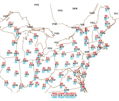
Binghamton, NY just had a SEVEN day stretch of record warm temps as they topped out at 71ºF Friday afternoon. Keep in mind however, KBGM has on been keeping accurate wx data for 61 years. The media probably will not alert the public to that which makes that 7 day stretch not so impressive....but nonetheless, rather extraordinary! Pittsburgh, PA has not had max temps 70ºF or higher for TWELVE consecutive days! For the period from March 12 to March 23, that too is momentous! And our local KMDT did establish a new record max for Friday as the mercury climbed to 79ºF at 2 pm eclipsing the old record max of 78ºF established in 1938 and 1907! It most certainly felt summer-like and by analyzing the max temps below, it WAS summer-like on Friday! I have to post Thursday's maxes as the NWS has yet to update the climatology for March 23...since it is still March 22 in some parts of our country as I am typing this...But here is Thursday; still far-reaching and historic warmth for March 22! Take a look...
I found this graphic showing the high resolution of the heat that accompanied the heat of Thursday. Note the cold of the lakes, the persistent upper level low over the southern plains, the snow covered Cascades and the O Canadian Rockies, and why the SE flow this week kept KMDT coolish and foggy as the coastal Atlantic at our latitude is quite cold...awesome hi-res surface temp graphic!
The bubble of heat will get knocked down this weekend by 2 atmospheric features. The first is this bowling ball of an upper level low that is slowly moving SE from it present location. Here is the 500 mb analysis as of 0Z last evening...
By Sunday afternoon, note to where this upper level low has migrated...
The other factor that will send us back to reality is the strong diving vort max seen above just to the ESE of James Bay. This will allow for some rather chilly air aloft to advect towards the lakes and New England and graze eastern PA with some back to reality temps for Monday and Tuesday. Here are the 850 mb temps for later Monday...
Not to worry though mates as this trough of reality will quickly lift out 36 hours later...
But another shot of O Canada is coming towards the northern tier of states for the latter part of next week...
So most decidedly, back to reality in terms of temps for next week as well as rainfall, too. With these cool shots from our neighbors to the north, we will also have opportunity for some showers to accompany these frontal passages. But frankly, we could use some rain as I was tilling my garden yesterday and the soil was actually quite workable and even darst I say DRY for the cool crop planting! Unreal for March 23! Here is the 7 day running mean for the period ending next Sunday, April Fool's Day! Clearly, the heat has retrogressed westward and the trough of coolness has become established in the northeast US.
As for the short term and the rain, here is the current IR satellite of where the coldest clouds and deepest moisture are located.
And the current radar to boot...
As the upper level low moves to our south and east, these bands of showers will move across our area over the next 2 days. It could literally rain at anytime from daybreak Saturday until nightfall Sunday. I think the greatest likelihood of precip is Saturday afternoon into early Sunday morning. By Sunday evening, here is what the NAM believes for our total precip in the region. It appears that ~0.5" looks like a good bet, but lesser amounts if you miss one of the bands of rain or over an inch if a band gets 2U...not U2!...Sorry...I'm listening to music!
So there you have it...Reality, Rain, Records...all in one fell swoop! And speaking of U2, I'm not sure to what Bono was referring when he sang this tune, but I'm fairly certain he was not referring to our May-like wx in March! This opening song was performed by U2 on their tour last year. The below video clip is from La Plata, Argentina about one year ago! Enjoy!
AA: The end of quite a spell of record warmth across the east, some showers this weekend, but not raining all of the time, and more typical early spring-like wx for next week! Have a great week's end my friend!


