Saturday, July 30, 2011

Enticing Emily

Before I get to the main topic of today's post, what a wonderful summer day we enjoyed weather-wise here in central PA!  The morning dawned a bit damp and the air still quite humid, but by early afternoon, the northerly winds mixed out the low level humidity and lo and behold, a glorious summer day ensued.  The satellite pic shows the cloud free skies in our region.  You can also see clearly the front that passed through our area yesterday some thunderstorms that are developing in the humid air masses to our NW and to our SW.
 
Our Sunday looks to be a repeat of today with some cumulus popping up as the upper air will be slightly cooler than today.  As a result, condensation will be occurring at about 5-8K feet and some nice afternoon cumulus will develop during the max heating of the day under the strong July sun.  The dewpoints will be relatively low and there is virtually a zero chance of rain tomorrow as seen by the graphics below.
Here is the probability of any precip country wide.  I believe the area just to the SE of DC is due to the hot air emanating from the Capitol.  Thus, downwind, convection is likely and storms could pop due to the abundance of BS in our nation's capital.
The main focus of this post however is to give a "heads-up" for those of you who watch hurricanes and our tropical islands and the east coast of the USA.  I believe that by tomorrow at this time, tropical storm Emily will have a name.  It appears at this time that Emily will slowly grind herself WNW through the leewards towards Puerto Rico and impact the commonwealth of PR in the Wednesday time frame.  This could be a major hurricane, although the modeling is not going to that intensity as of this posting.  Below are both the IR and the WV satellite images of the storm gathering her wits.
The WV image shows what will need to be overcome and that is the dry (black) air that is advecting SW ahead of the storm.  This may hamper the strengthening process but the environment is conducive to hurricane strengthening over the next several days.  So I am putting out my own Hurricane Watch for Puerto Rico for on/about Wednesday.
As you can see, there is a wide spread amongst the models that sniff these things out.  But, there is a trough that is diving off the east coast of the USA which should keep this storm moving in a WNW direction and not curve to the N and the NE before it impacts the Bahama-mamas by Friday/Saturday.
And the forecast intensity of Emily:
Please understand, this is very, very, very preliminary as tropical weather marches to its own drummer.

In closing, I liked the Phillies trade deadline acquisition of Hunter Pence.  This kid is a baseball player; cut from the cloth of a Chase Utley, or a "Shoeless" Joe Jackson.  He just likes and wants to play baseball.  The Philly phaithful will quickly begin to love this guy.  He comes to play everyday and plays the game it was meant to be played.  He's relatively young as well and his offensive numbers playing on a bad team were good (OPS 0.800)!  Defensively, he is quite the upgrade over anyone else the Phils might put out in right field other than John Jr.  So, once again Rueben, well done!  I read a comment that made me laugh.....the pencil neck Ed Wade has put together a better team in Philadelphia now that he is in Houston as compared to when he was the GM in Philly!  Imagine that!
As for any Pirate fans reading this, I truly feel your pain for the criminal act that Jerry Meals purported this past week in that 19 inning marathon.  What a horrible way to end any game in MLB!  That may have been the absolute worst call that I have seen in ALL OF SPORTS EVER!

Enjoy your gorgeous Sunday whether you're at the Bank, or Yankee Stadium, or just slumin' it with the mere mortals here in central PA!

Smitty

AA:  Beautiful weather Sunday, but watching the tropics and a potential hurricane for later this week to potentially affect Puerto Rico and the Bahamas and maybe the east coast of the USA next weekend.


Wednesday, July 27, 2011

Wonderful Weather Wednesday

Today will be the most delightful summer day over the next several.  This is the current water vapor image.  Note the humidity coming over the top with the complex of storms over the upper mid west.  This humidity will get to us by tomorrow.  So enjoy today's low dewpoints and warm temperatures.
Friday will be the peak of the heat and by Saturday, the anomalous temps will begin to be shunted to the south and west of PA as seen below.
Saturday's deviations from normal.
 By Sunday, a front that will be moving from the NW and allow high pressure to build once again.  However, this air mass is not as pristine as the one we are currently enjoying, so although temps will not be cool, they will not be extreme either.  Humidity will be moderate and thus allow for pop up thunderstorms to develop really at any time due to the cooler air aloft. 
In closing, it was refreshing to see a young pitcher complete a game for the Phillies other than their famed seasoned veterans.  The jury is still out on "Vanimal".  Time will tell to see if he is as effective as he has shown to this point for the long haul, and two, if he even remains a Phillie.  I'm not so sure he just didn't groove a ball to Rowand in last evening's game for old time sakes.   No one would ever suggest such a thing, but that pitch was total in Aaron's wheelhouse and he delivered for the Philly phaithful that like to see him do well.  Not to mention, the game was over in just 2 hours!  Go Phils!

Enjoy your Wednesday.

Smitty

AA:  Nice weather today, getting warmer and more humid through Saturday.  Then a front comes through Saturday evening...not very strong though.  Phillies have a young pitcher who is doing very well his first time through the major league teams.  I'm seriously considering the trade.

Tuesday, July 26, 2011

Comfortably Warm for Mid-Week; Hot & Bothered in DC

The radar picture above shows a secondary cold front pushing through right at this time Tuesday evening that will bring in even drier air than we experienced today.  The air mass this am early (~4am) was still very humid; however, by a couple hours after sunrise the humidity dropped to about a 65 dewpoint.  By afternoon, the dewpoints dropped to about 60 F!  The map below shows the progged dewpoints by the GFS for tomorrow afternoon; it will still be somewhat comfortable Wednesday afternoon into early Thursday but that bubble of humid air over Iowa will be slowly working its way ESE.  That real oppressive air will not make it into PA. 
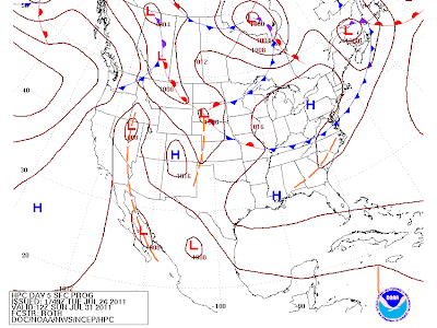
In fact, this next heatwave will struggle to become a bonafide 3 day heat wave as the hot air will be shunted south by the NW flow in the mid levels of the atmosphere. This is the forecast for the 500 mb level for Saturday afternoon.  The NW flow pushes the "heat bubble" back to the SW where it belongs at this time of year.  This is a classic positive feedback loop; dry ground, sunny & clear skies, hotter ground, drier ground, sunny & clearer skies.....you get the idea.  Just like in sports....winning breeds winning.  In wx; dry ground breeds drier ground!  See below......
For early Thursday morning, we will be experiencing a classic example of what in the cold season is often is referred to as cold air damming.  That wedge of dry air will be sent right down along the Appalachians and shows beautifully by the modeling for Thursday's progged dewpoints.
The peak of the heat appears to be Friday as shown by the GFS ensembles and their associated anomolies.  This is the greatest extent of the Bermuda High shown by the brown isobars on the map below.  In about 3 days after, that bubble of high pressure will migrate west towards the drought stricken southern plains and allow a slightly cooler flow of air towards the NE USA.
In closing, I'd be remiss if I would not comment on the abortion called Washington DC and our supposed democratic process.  If there is one arrogant SOB that I wish would drop off the political landscape of DC, it is the senate leader Harry Reid.  How this idiot ever got to the position that he presently holds, I personally am dumbfounded!  When the pseudo leader of this country calls for compromise, this arrogant SOB says that there will be no floor debate of "Cut, Cap, and Balance" (even though the president wants a "balanced approach" according to his campaign speech last evening), and that the new House Bill that is presently being constructed is "dead on arrival" once to the US Senate.  What an uncompromising bastard!  No wonder our country is becoming a laughing-stock with this type of leadership in various roles of our government!  Even though this graphic below is over a year old, it still speaks volumes!  Especially since many are jumping ship as will "cheaty" by the end of this calendar year.  And the new "Dopey" isn't much better!
Enjoy your comfortably warm Wednesday with low humidity.....before the heat and humidity returns.  I believe it was Yogi Berra that stated so succinctly that "It's not the heat, it the humility!" 

Smitty

AA:  Comfortably warm Wednesday with increasing heat and humidity through Friday.  The weekend will still be warm and humid but not nearly as bad as the recent heat!  Still a gridlock in DC with horrible leadership IMO!  The only good thing about this impasse is that we haven't had to listen to the global warming poppycock from the liberal left!