Saturday, September 22, 2012

Summery Saturday; Autumnal Sunday

Today at 10:49 am EDT (1449Z), the sun began its 3 month journey to the Tropic of Capricorn from the equator of the earth & sky.  During that 3 month period, the sun angle will continue to become lower in the noontime sky (50º altitude at noon today at our latitude of 40ºN) and the the day length will lessen until December 21. This is our season we call "fall". Below is a diagram showing the noontime position of ol' Sol at our latitude during the 4 seasons of the year...
But outside today, it was awfully warm and the sun felt like it was much higher in the sky than 50º during the midday!  At our humble abode, 80ºF was easily achieved in spite of me assuring my wife earlier in the day that 80F was "out of the question"!  I'm still hearing about it....Oh well...In the same breath, I'm assuring her that Sunday will be much cooler than what we experienced today!  At least the GFS ensembles suggest that...
The leading edge of this much cooler and drier air mass is being indicated by the broken line of showers and storms presently crossing PA...
And the upper air is supporting this frontal passage as seen by this very deep trough...
And I believe that most of this week will be at or slightly below normal after Monday which will be much below normal.  In addition, it will be very chaotic in terms of the wx forecasts as the ensembles are having trouble with what potentially may end up being a "cut-off" low under the main jet which lifts north of PA.  "Cut-off low; weatherman's woe!"  The ensembles are showing signs of "cluelessness" as they are literally all over the place in the medium range of only 180 hours from now!  The white line is the operation; however, the red lines are the individual runs and note that most are well south of PA indicating cooler and possibly damp wx...agree?
The resulting temperature anomalies indicate neither warmer nor cooler thabn the 30 yr average...
So there you have it...I'm sorry I'm not 100% focused on this blog as I am watching what I consider a very entertaining NCAA football game between Temple and PSU.  Michael Zordich is quite the force on offense just as his daddy was when he was playing for PSU during my years in attendance Penn State!  Zordich was one heck of a defensive player; "hero" or "monster" if I remember correctly...His son knows how to deliver a blow carrying the football similar to his dad who hammered receivers coming across the middle or QBs who felt his blitzing capabilities!  Temple is a solid football team and Penn State is much improved as they learn what O'Brien wants to accomplish on both sides of the football. 
FIGHT ON STATE!  OK...I think it's a conspiracy, but I tried to upload the PSU fight song....but Noooooooo....not with Blogger......so here is a song I listened to many times over whilst I attended my Alma Mater...enjoy the blues....

And enjoy the remainder of your weekend....

Smitty

AA:  Much cooler tomorrow and Monday...then seasonal through the week with what then I believe to be a damp and cooler than normal Friday through Sunday period...

Thursday, September 20, 2012

Western Europe to Get "Fujiwharad"

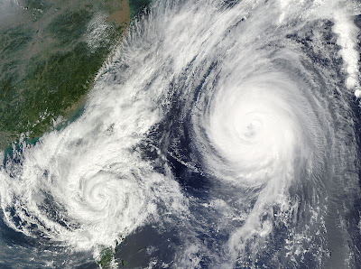
OK...so what the heck does that mean?  Does that mean the European community will solve their fiscal woes by following Japanese financial policies and get their money problems to a more manageable position?  NO!  But, in terms of a statistical rarity, 2 storms of somewhat tropical origins will be effecting the European continent over the next week.  See, I read about this from another source and found it interesting enough to share with y'all the potential of some rather wild weather occurring across the pond during the next 7 days!  By the way, the Fujiwhara Effect is an interaction of 2 tropical systems doing a Fandango, usually out over the open ocean.  Here is a satellite pic of such an occurrence 3 years ago...
So, by using the European operational model depicting the mean sea level pressure (MSLP) over the next week along the western portion of the European landmass and adjacent oceans, watch what may transpire in some term of some rather wild weather for many of our NATO allies.  First, Saturday morning.  High pressure over merry old England with a nice storm just west of Portugal...
Sunday am...A large area of inclement weather begins to materialize from Iceland over to the Bay of Biscay.  Note to the SW is tropical storm Nadine...
Monday am...The low pressure consolidates over central England and Nadine lurks to the SW...
Tuesday am...Now that is one heck of a gale just to the north of northern Ireland!  The Celtic and Irish Seas will be rockin'!  Nadine inches closer to the Iberian Peninsula...
Wednesday am...now the low pressure fandango commences...Standing on the Rock of Gibraltar could be rather interesting at this time!
Thursday am...Spain and Portugal just got rocked by dare I say an Atlantic tropical system!  And she's coming to pay the Londoners a visit...
Friday am...A tropical storm just to the west of London...say over by Bath, Bristol, or even Stonehenge!  If it were further east, maybe we could add a Chapter to the Canterbury Tales.....sorry!
So there it is...a rather stormy time is in store for western Europe and the UK.  Now, whenever tropical systems are involved, it can be somewhat like a crap shoot trying to pinpoint details of the storminess.  However, the ocean water temps off the west coast of Europe do support storms to hold on as there as anomalous warmth is present in the adjacent oceans of western Europe.  Take a look...
So, I found this scenario rather interesting and thought I might share all of this with with y'all...after all, our own weather is not too interesting other than a shot of true autumnal air for Sunday through Tuesday.  The 850s have a freezing temp all the way down to our latitude for Monday am.  Thus look for some patchy frost not too far away from KMDT if calm conditions settle in for a perfect radiational cooled nighttime! 
Here is a one day temperature anomaly for us next Monday...~6-9 below normal for us...
So there you go...can you tell I haven't had to work many games this week?  Time to teach, study the weather, and read all of the pros and cons for the new iPhone 5!  I will attest to the fact that new iOS 6 is most certainly speedier in certain applications and SIRI and my car's Blue-tooth are now seeing "eye to eye" in a much more efficient manner.  Perfecting the voice acquisition is a huge improvement!  Apple stock at $700.00 a share is unreal...the question is can they continue to deliver products that this techno savvy world wants and or needs for improved quality of life?  I believe the long term answer is "yes".  Let's see how the iPhone 5 sells on its release tomorrow...time will tell.

Enjoy your week's end!

Smitty

AA:  Western Europe to experience some wild wx next week.  Cool to cold for us next Monday...should've bought Apple stock back when I was punching the keyboard of a II GS!

Welcome to Autumn

At 10:49 am EDT, the equator of the sun will lie directly over earth's equator (and heading south for our winter) thus marking the exact time of the autumnal equinox.  With that said, the wx in the northern plains this weekend and southern O Canada will be more winter-like than early autumn.  Let me quickly show you what I mean...First a snapshot from the NWS and their forecast for Ely, MN which is in the boundary waters wilderness canoe area in the arrowhead of Minn-ah-So-tah...
Now the 850 mb temps certainly suggest a deep trough of Canadian origin air will be intruding the lower 48 this weekend.  Take a looksie...that is a direct N-S flow of air at 1 mile up aiming at the northern lakes!  It will be chilly here as well later this weekend and into early next week.
The map below shows the expected snowfall to accumulate through Monday morning!  If it is a deep purple, then there will be some snow on the ground.  The light purple's indicate snow in the air.  But still....it is only September people!
And note the ground level temps Sunday morning.  It appears that the growing season will abruptly end in a large percentage of the northern plains this weekend and even in some parts of Appalachia!  It's all about Anthropogenic Global Warming as you all know!

So just a quick hitter as to the change of the seasons that will start to become more and more noticeable with each passing and might I add shortening daylight day! 

Enjoy your Thursday night NFL game' your MLB wild card chase games, no NHL preseason....sorry, or whatever else you might enjoy.  And if you're at a loss, enjoy this classic oldie since I mentioned "Deep Purple" earlier above...Not a huge fan of this group, but this most definitely rocks!
Happy week's end!

Smitty

AA:  Cold in the upper Mississippi Valley and actually fairly chilly in these parts as well!  Enjoy your weekend!