Smitty's attempt to educate and to a much lesser extent, entertain, about all facets of life; but primarily the meteorological and the climatological aspects of the earth sciences.
But we will have one last burst of snow as a deformation band sets up somewhere near the Lower Susquehanna Valley as the storm begins to pull north and east. Thunder-snow was reported around the 1 pm hour in the Harrisburg area and visibilities are less than 0.5 mile for several hours this afternoon. Here is a visible satellite image of the storm....note the bubbly clouds that are precipitating heavily and the "eye" that is trying to develop in the "snow-cane" that we experienced here today!
And here is the IR satellite image showing the classic comma shape for this incredible cyclone. The pressure of this system should attain ~992 mb or lower at the 40th parallel! It will deepen further as it pulls away and thus winds will strengthen overnight.
The NWS office at State College has added some new graphics for wx obs over the past couple of days. Here is the visibility observations over the last 2 days. Note the lowering ceiling and low visibility during the height of the storm. Note how the last hour obs the visibility is improving; how depressing! As of 5 pm, KMDT has received 1.38" of liquid creating our 5" snowfall. Doing the math equates to ~4:1 ratio; a very wet snow! Do keep in mind that ~0.25" of that liquid fell prior to the changeover to snow early Saturday morning.
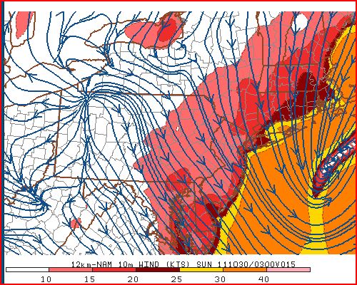
Here are the modeled winds for just before midnight.....
And here are the forecast lows for Sunday morning...quite a cold morning for October 30. The previous record minimum is 24F in 1965. We will be close and should get to it the skies clear out by say 3 or 4 am. The winds would also have to abate.
This storm's impact will be affecting many people over the next few days. It's one thing to lose power when temps are mild or even warm; its another story to lose electricity when temps are in the 20s at night! Here is a county by county count of service outages for both PPL and Met-Ed as of 5 pm!
And Met-Ed's site was overwhelmed for part of the afternoon! Trust me, there were over 10,000 outages in York County alone as of 2 pm. I hope y'all can read this and therefore have not lost power!
Well as the storm winds down (as of 5 pm, KMDT has officially received 6.0" of snowfall), I will settle back in front of the TV to view a punting clinic and turnover delight from State College, PA under the guise of a Big Ten football contest!
Enjoy the remainder of your weekend.
Smitty
AA: A record breaking snowstorm for October 29! I hope you guys don't lose power! Be safe if you venture out and turn off the water!
I know, I know...Mr. Chicken Little coming to y'all live from Etters, PA! But if what the modeling is suggesting verifies, south central PA will have bestowed upon it from mother nature some of the worst possible weather conditions for this time of year. With heavy wet snow, the weight of the snow will easily bring down trees and power lines and large scale outages WILL occur! With that said, just prepare yourselves with the potential of losing electrical power for at least 24 hrs as what the modeling is now suggesting is simply a recipe for disaster. I do not want to overstate my position; however, I most certainly do not want to underestimate what I believe could be a crippling event for the south central region of PA! The 1st map I'd like to show is where the NAM believes the heaviest snow will accumulate. Note the areas where the lowest temps are being shown on the map below. One can extrapolate that this is where the greatest amount of snow will be lying on the ground as of Sunday evening late. 28F isotherm is essentially bulls-eyed over Lancaster County!
Now let's see if the NAM is correct. Here is the literal output from the NAM. I highlighted 3 areas; the total snowfall, the beginning of the snowfall, and the heaviest snowfall rates. Remember for those of you who want more than the AA, you can click on the graphic and it should get larger for your viewing pleasure!
Wind is also a real concern especially with the weight of the snow. Here is a map showing the winds and the location of the low as of 10 pm Saturday night. I don't think this is what the Bay City Rollers had in mind with their hit classic from 1976 (#1 on Billboard's hit list!). That is quite a nor'easter! At this point, cold air, from all levels, will be drawn towards the center of the low just off of NJ coast by less than 100 miles! Quite the gale center to be sure.
And the Euro most certainly agrees! I believe places like Mt. Pocono could receive upwards of 2' of snow when all is said and done.
So let's see how all of this plays out. If the NAM is correct, it could get ugly around here for the bulk of the weekend even though the storm is past just after nightfall. Winds will be gusty knocking down trees and power lines. Then, unseasonably cold air will be entrenched for the next couple of days. But, good things come to those who wait. As you can see below, temps will moderate to above normal if the modeling verifies and the upper air pattern is as shown by the Euro for late in the upcoming weekend and early first full week of November.
So I wish I could bring you better news....but unfortunately, this is what I am seeing. I believe this could be an historic event; a once in a lifetimer meteorologically. Please remember that climatologically, the sun angle is comparable to mid February, and we can recall some of the infamous President Day storms over the years. Yes, the ground is warm, and the lower troposphere is just coming off of summer, but with the strength of the storm and the dynamically lifted air, we are going to see snowfall of unprecedented proportions with this nor'easter. I marked with a blue "X" where the storm appears to be early this Saturday morning. Note the 25 kt winds just north of HSE!
In closing, I'd like to acknowledge that for the 2nd year in a row, the Phillies lost to the eventual World Series Champs. Being a National League MLB fan, (I despise the DH in the AL!), I am very happy for the St. Louis Cardinals as they played like champions for the last month of the season. Had it not been for the Phillies hammering the Braves at the end of the regular season, St. Louis would not have even been invited to the postseason parade for 2011. As fate would have it, the Phils pound their nemesis, and lose to their replacement. Isn't it Ironic; don't ya think? So a big congrats to the Cards and their fan base which does run deep across the country as witnessed by the hats and shirts seen sported in these parts the last few weeks.
Enjoy this ditty about St. Louis, Missouri and your week's end...and be careful out there!
Smitty
AA: My best bet is ~8" officially at the airport by nightfall when the storm is essentially over and moving rapidly up the coast. It should changeover by 10 am and snow will fall heavily for several hours through the afternoon. Thunder snow is also a real possibility with this rapidly deepening storm. Power will be out for many for several hours. I ACTUALLY HOPE I AM WRONG WITH ALL OF THIS!! Then, clearing and a bit blustery yet Sunday and COLD for this time of year. Temps will moderate and the pattern will settle for early in the upcoming week as another storm appears to just miss us Tuesday-Wednesday just off to the east. Then watching yet another storm (warmer) for next weekend, but the Euro says no at this time (as does the Japanese model!) Have a good weekend my friend!
As most of you know by now, I love the winter season and snowstorms in particular. With that said, I'm still hesitant to call for what the major modeling from around the globe have trended towards for over a week now....all except the lovely American GFS. After this morning's run of the Euro, I felt a little more confident that a real potential exists for an early season, possibly once in a lifetime historic snowfall for our region. After seeing the 12Z Euro and the finally the GFS, I am now quite confident that snow will fall in our area and accumulate several inches very quickly during the daylight hours of Saturday. Most of the accumulation will be on non-paved surfaces, but therein lies the problem. With gusty winds, a heavy wet snow accumulating on trees and power lines WILL DO SEVERE damage if this snowfall verifies! Here's the Euro for Saturday evening...
And here is the GFS for the same time...
They look fairly close in their agreement! Here is a quick look at the plumes for KMDT. Note that most of the ensembles are all snow and the average amount of precip is over 0.6 inch! Even at 5:1 ratios, we're looking at 3 inches of heavy wet snow on grass and trees! Couple that with wind and we've got some issues. Look for greater accumulations in the higher terrain of our region!.
Here is the NAM's snowfall ending Sunday morning. That is quite a snowfall. I believe the heaviest belt will be west of where the NAM algorithm has it located. This is unreal....I wish it were January, I wish it were January....
As for Friday night lights, look for mostly clear skies with some high cirrus moving in as a precursor for Saturday's event. Winds will be gusty during the day, but once the sun sets, they should abate and temps at kickoff should be in the mid 40s; nice fall football wx! Take a look at the progs for temps and winds for Friday pm....
And now winds...
So there you have it...October's version of a nor'easter coming to the Mid-Atlantic. For some a trick; others a real bona fide treat!
Have a great Friday!
Smitty
AA: After a nice, but coldish Friday, watching a nor'easter crank for Saturday with limb busting snows on foliated trees!
A hit along the eastern seaboard with coastal rains and inland snows that would actually accumulate of grassy surfaces and trees and powerlines. The water content would be quite high and it could actually be quite an ordeal somewhere between northern MD and ME. Here is the latest run from the Euro...it is quite a storm with ample cold air entrained to do some serious wintery precipitating!
As for the middle of next week, the Euro takes the remnants of Rina too far east to deliver any heavy rain to our region...and that's not a bad thing. I'm just not convinced yet that will be solution, but it looks like Rina's remnants will be a swing and a miss!
This late week's forecast was challenging from the get-go. But I was fairly certain the cold was coming. And as shown below from the NWS, a freeze watch has been issued for our immediate area Thursday night into Friday morning. This watch extends into northern MD as well. See below...
With the passing of a weak low pressure system just south of PA on Thursday, cold air will advect south once the low passes our longitude and send cold air bleeding south into the Mid-Atlantic. Most of the precip will be past, so snow will not really be an issue for the KMDT area. However, in the northern and northeast part of the state, snow could accumulate a few inches, especially at elevation! Here is the latest NAM's take on accumulated for Thursday's snowfall.
But the real interesting situation develops late Friday into Saturday. The modeling is now coming into some sort of consensus, that being a storm, not as strong as originally modeled, and slightly off the coast a bit further. BUT CLOSE ENOUGH TO AFFECT OUR WX SATURDAY. The Japanese model is the most bullish for nasty snowfall for our region during Saturday into Sunday. I believe this scenario is a bit overblown! This would be a major snowstorm from downeast ME to around Philly!
The Euro is a bit flatter and further away from the coast, but still having an impact along the I-95 corridor...and possibly back to us here in Harrisburg!
Then the Japanese model spins up a doozy from the remnants of Rina which is currently spinning her way around the Gulf! Look at this moisture laden system. This solution does have some potential for the middle of next week! Snow is not a concern with this as the thicknesses are much higher (warmer), but heavy rain would be a concern!
So as we march onto November, the atmosphere begins its countdown to winter and the cold weather season. Had this pattern set up like this in December and January, my oh my, this would be rather intriguing! But it is only October, and winter type precip is transient when it occurs. But I do believe people will get a real dose of cold when Friday morning arrives and feel just how cold it became so quickly. So I hope you enjoyed this last mild day for quite some time as the afternoon temps achieved 66F; it felt quite balmy at Landis Field. But the cold air is ready to pounce and be in our area in spades beginning late Thursday and through the weekend. Sunday will prove to be a nice day with a huge dome of high pressure over PA as shown below, but it will still have a bit of a bite to the air.
Speaking of bite, Happy Halloween y'all. After all, Halloween has its origins not in ghosts or goblins, but as a cross quarter day, that being a day halfway between the Autumnal Equinox and the Winter Solstice! All Saints Day falls close to the 4th Quarter Day of the Earth's Revolution cycle. Halloween, a pagan celebration of All Hallow's Eve was recognized close to the 4th Quarter day of the annual solar cycle. It still seems to be the most celebrated of the quarter days, although I'm partial of the celebration commemorating my buddy from Punxsutawney, PA, that being Groundhog's Day!
Enjoy your end of the week!
Smitty
AA: Damp and raw Thursday with rain ending as the cold air arrives, then a cold Friday with the potential for some wintry type precip on Saturday. Middle of next week, we could have a real soaker from the tropical disturbance down in the Gulf tonight.
I just thought I'd share what the modeling is doing for this weekend's potential wild and wacky weather. First, let's start with our own Navy's model of the atmosphere. After all, there are nuclear physicists in the US Navy....right? It has quite the nor'easter, maybe just a bit too far east to cause real havoc in PA. But it would be interesting!
Now here is the fair weather O Canadian. Two high pressures over the Mid-Atlantic for Saturday. Just cold and dry to be sure.
Now the Euro...I believe this model has been the steadfast rock of atmospheric interpretations over the recent years and usually has a clue from this time frame. This would make for some rather ugly wx in PA, especially in the mountains where accumulating snow is represented by its 12Z run as of today. Take a look.....
The GFS is flat with a storm, albeit 300+ miles offshore of ACY. Cold, dry NW flow!
Now here is one of the runs of the GFS ensembles...it looks as if I hacked into their system to create this monster!
And here is the British Isles' UKMET run. It too has a major storm, although not as cold as any of the above models.
And lastly, the "official" position as taken by the forecasters at HPC as shown by their surface map for Saturday. It appears as if they are leaning a bit more towards the United nations of modeling and veering away from the GFS to some extent!
It will be interesting to see how this heat, humidity, and upper air trough resolve themselves this weekend. Maybe when the Fighting Illini come to Happy Valley, it will be one of those mid-fall games where the State College wx becomes a factor in the outcome of the contest on the gridiron. As we all know, that PSU defense needs all the help it can get because it is surely not getting any consistent efforts from it own offense. How about an 8-1 Lion team going into their last 3 games? Not too shabby! Oh, but those last 3 games.....Nebraska, at OSU, and at Wisconsin. If they would win 2 of those, then the Nittany Lions are legit and roar would be restored to their glory days of the years gone by!
Have a good remainder of your week and if things get any clearer, I'll be sure to update them on Twitter. Follow me on Twitter @SmittysSynopsis if you so desire......
Smitty
AA: The end of this week and into the weekend look very interesting! Probably a wet and raw time through Saturday followed by a cold NW flow for Sunday and Halloween.
Just a quick note to share with y'all that the models are conflicting in their solutions for the end of this week. As I mentioned over the weekend, there is a tremendous amount of heat and humidity that must be reckoned with as a sharp trough digs southeastward towards the Mid-Atlantic region. First, here is how the Euro depicts the surface map and winds at a mile up for Friday morning. This would be one cold, raw rainy day for our immediate area and snow in the mountains of PA and points northeast.
Now here is the GFS for the same period. This shows a much more sheared out storm with a trough, but a much flatter solution than the Euro. The GFS ensembles are even drier looking than this operational run.
So which is correct?? I believe the ultimate solution lies closer with the Euro with a rainy and raw solution. And 2-3 days later, another storm spins up on the Euro as shown below! Both the GFS and the Euro agree on cold to rule the later part of this week through the weekend!
One thing for sure is that it will be the week's end and how can that be a bad thing?!?! You wascally wabbits!
Smitty
AA: Looking at a tough forecast for the end of this week. It will be cold from Thursday on and getting colder through the weekend!