OK...OK...but what about PA? Well, we are experiencing about as normal of summer weather as we can for July. Today, dew points reached 70 at KMDT, but just 75 NW of here dew points were in the upper 50s. That is over 50% less water vapor in the air which makes all the difference in the comfort level. In addition, a thunderstorm passed within ONE MILE to my south, and based on radar, over 0.25 inch of rain would have likely fallen.....but Noooo, not here where we are in desperate need of rain. Our Perry County contingency received over 2.0 inches the other night when I struggled to achieve 2 tenths of an inch! That's 0.20! That didn't even make the weeds in my lawn grow! Below is the radar pic of how close that storm cell was to my humble abode in northern York County this afternoon. So close but yet so far....
I guess it's pretty pathetic when I'm watching TB and the Twinkies (Longoria went yard in the 9th and might be snapping out of his funk!) in the mid-afternoon hoping for this storm to give me more than some boundary layer mixing and some gamely wind gusts! Oh well.....
As for our next few days; more of the same. We are on the boundary of some fairly wicked heat that will make a run at us this weekend; namely Sunday and Monday. This heat will come in over the top so to speak as the upper level winds will still be somewhat NW but the heat will round the corner and down slope the Alleghenies giving us possibly the hottest wx of the season. Sat/Sun should not be too humid; but by Monday and Tuesday of next week, the humidity might be here in spades. Until then, we are again very close to a boundary as evidenced by the gradient of dew points I observed today. The IR satellite shows where the convection is firing along the boundaries between the dryness of the air masses, not so much the heat since the temps do not vary much at all over a relatively short distance geographically. The satellite below shows the boundary just to the south of PA and the other boundary separating very dry air to the north across northern PA and the Great lakes. I also highlighted two areas of tropical concerns; the one that may develop off the GA/Carolinas and the other wave that may spin up in the Gulf. These both need to be monitored. The Phillies could have some rain issues this evening in south FL!
Here is the maximum extent of the heat for next week for us in PA. Note how the 500 mb ridge makes it into PA, but barely at best (left map). The center of the heat is in MO and moving west by the end of next week.
In closing, I will leave you with some time lapse footage of the haboob over Arizona. When I was 26 years old and vacationing in Arizona in the summer, I saw many warning signs on the highways concerning dust storms and what to do when encountering one. I really thought nothing of it at the first passing. But seeing that we were there during prime time so to speak, sure enough I was "lucky" enough to experience one. We needed to pull over on I-15 where dime sized pebbles were striking our rent-a-car (1988 Buick La Sabre....it had some horsepower!) and actually cracked the driver side rear window. I was in awe of the gusty nature of the otherwise clear weather! Simply incredible! But, once that passed, that gave us something to talk about and off to the San Francisco Mountains NE of Flagstaff, AZ we cruised and another weather experience etched in my memory banks. Here is the video shot in time lapse. The entire sequence took less than 5 minutes. Gusts were reported in the vicinity of this video of 69 mph!
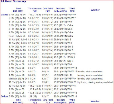
And here are the obs for PHX, AZ from last evening. Holy haboob, Mr. C!
Off to watch the Sillies as it appears most of the rain is to their NW..... Have a nice Thursday....
Smitty
AA: Unique dust storm over AZ last evening and typical summer time wx here. best chance for widespread storms will be Friday if you need rain like we do here in the metropolis of Etters, PA! Also hoping Lester isn't too banged up.


No comments:
Post a Comment