I know that's it has been awhile, but I needed that time away to gather my thoughts on what was and what is and what is to be. Not only did I take a brief vaca from central PA, I took it from the global weather patterns as well. Locally, this month of August has been a very wet month. In fact, PHL will smash its all-time monthly record rainfall of September 1999 of 13+ inches within that month (mostly due to hurricane Floyd) without any tropical storms but simply the lowering of the atmospheric heights creating numerous showers and thunderstorms. What that really means is that the surface has still been hot and humid in the early part of the month, but the upper air has been cooling dramatically leading to these outbursts of heavy rainfall. The Harrisburg area has seen this as well, but closer to the warmer ocean, the storms have been relentless. Philly will surpass its record tomorrow with the passage of a cold front as shown below. This front has the potential to create some marginally severe wx, but the bulk of the energy will be to our north and east. We should see some gusty storms during the afternoon Sunday.The above is a snapshot of Sunday about 4-5 pm. But rain could fall at almost anytime tomorrow from 10 am onward. Once this front passes, much cooler and drier air from O Canada will be ushered in on a brisk NW breeze for Monday. Highs on Monday and Tuesday will be in the 70s as shown below. Beautiful weather for fall sports practices....don't cha think? Highs on Monday...
And highs for Tuesday....
But what I really wanted to give a heads-up on was the potential of PA and the entire east coast of being adversely affected by what will become Hurricane Irene. We've had 8 tropical storms to date, but not ONE has achieved hurricane status. That will change with Irene. Below is the latest satellite image of the tropical waters near North America and where the National Hurricane Center has highlighted areas of interest for tropical storm development. The area in red labeled as #1 will become Irene maybe by this evening.
Here is another close-up IR satellite image of Irene to be. Note the circulation of the convection around what will become the warm core eye of the storm.
And here is yet a 3rd satellite image of this area in general showing its proximity to the islands and to Florida and the east coast of the USA. Harvey is entering Belize south of the Yucatan Peninsula.
I have included the runs from both the American GFS model and the European ECMWF model to compare their projected paths of this tropical becoming extra-tropical storm once to our latitude. If these paths would verify, flooding rains would be a near certainty in our region in light of the wet August we have had to date. Here is the GFS track....1st in FL on this upcoming Friday, August 26.
Then over the mid-Atlantic 3 days later....
Again, if that would verify, we'd be looking at a 12-24 period of wind driven squally type rains with the potential of some places to the east of its center receiving 10"+ of rain! Now here is the Euro's depiction of this system....
What is quite concerning to me from this amount of time out from the event is that both of these global models seem to want to place the center of this monster somewhere near central PA.....and this is 8-9 days away.......so it is something that bears watching.....as does this trailer from one of Jim Carrey's dare I say masterpieces?!?
Have a great weekend!
Smitty
AA: Storms Sunday leading to nice weather for Monday and Tuesday.....see you Thursday...uuuugh! Then we can talk in person about the upcoming hurricane that may affect PA??!!
Smitty's attempt to educate and to a much lesser extent, entertain, about all facets of life; but primarily the meteorological and the climatological aspects of the earth sciences.
Saturday, August 20, 2011
Sunday, August 7, 2011
Heavy Rain in Southern Dauphin County
Here is a quick update from Barstow, CA flying on I-15 from Vegas to LA! If you ain't going 90, you're getting passed! It's also where the cycles pass you on the center white lines....you know the ones that where Commander Cody sings about in The Hot Rod Lincoln that had "them telephone poles looked like a picket fence" and where "the lines on the road just looked like dots."! Listen below for a blast from the past.
Anyway, as we clutched through the desert and the cloud free skies, I just thought I'd share this one graphic of the rainfall from Saturday (08-06-2011) evening. These are quite impressive 24 hour totals! One loyal reader reported 4.5 inches in Progress during his 24 hour observation!
Then a week later, a similar rainfall event occurred just to our east. This past Sunday, the south NJ area had their 5th wettest all time rain ever! It did more damage than Floyd in 1999! Central PA was lucky to dodge this bullet as many of the local forecasters stated that the heavy rain would be here in our area. Here is a quick snapshot of Burlington Co. NJ and its 24 hour rainfall totals. The county of Cumberland, NJ just to the south of this graphic had reported 9.29 " from an official spotter from the NWS.
As for this post, I was unable to troubleshoot when I was out west. I was also unable to study the weather as much as I like to note the upcoming pattern, etc. One thing though that I believe will be the case is that the extreme heat is kaput. The heavy rains of the past 10 days in the east mark the ending of the extreme conditions in terms of heat and very high dewpoints here in the NE and Mid-Atlantic region. Both the GFS and the Euro show a deep trough over the east 10 days from now. With another frontal system poised to pass through on Thursday, I don't see any real heat in the next 2 weeks. Now I know that summer is unwinding, but August at times can be brutal. I don't really see that the next 2 weeks! He is the graphic indicating the trough over the eastern USA.
Being unable to troubleshoot this post out west, I did want to share these rain totals with everyone. While some have a flooded basement, others still needed to water the tomatoes. It is just the nature of the beast; this summertime convection. Flash floods are very destructive and with even more development in places where water likes to run, there will be greater amounts of loss of life and property with these sudden rain events. While out in the deserts of AZ, NV, and CA, many dry washes were quite evident. However, even being there in the height of the monsoon season, we saw no rain and nary a cloud in the sky. As the photo below shows, I will still need some time to recoup and get my thoughts together about this crazy phenomena that we call weather.
So for now enjoy your mid week and anytime that remains for many of you away from the "salt mines"!
Smitty
AA: Heavy rain Saturday (08-06-2011), and then the following Sunday (08-14-2011) and the beautiful CA desert!
Friday, August 5, 2011
Geomagnetic Storm Warning
Space Weather Message Code: WARK07
Serial Number: 32
Issue Time: 2011 Aug 05 2146 UTC
WARNING: Geomagnetic K-index of 7 or greater expected
Valid From: 2011 Aug 05 2200 UTC
Valid To: 2011 Aug 06 0300 UTC
Warning Condition: Onset
NOAA Scale: G3 or greater - Strong to Extreme
So what does this mean? There is a good chance to see the aurora borealis even from our latitude. However, there is the issue of cloud cover, but the best time to observe an auroral display is close to local midnight.....so if you have wireless issues this evening, TV/satellite issues, it is due to this strong to extreme geomagnetic storm.
I wish I had more time to explain further, but I've got to get some shut eye for tomorrow's adventure. This is a graphic that shows where the likelihood to observe an aurora this evening. This is just a snapshot of a very dynamic and fluid event.
Click this link for further study:
http://spaceweather.com/
Smitty
AA: A geomagnetic storm is in progress.....
Thursday, August 4, 2011
Winds from the East; Weather is Least
Wednesday and today were a classic example of what happens when a subtle easterly flow keeps clouds locked in place as that air gently upslopes the piedmont and into the ridge and valley of PA. As I traveled about central PA today, I passed through several pockets of drizzle embedded in the overcast. Remarkably, the air above 5,000 feet was quite dry! It was the low humid air that condensed into our overcast today. here is the current visible satellite pic as of 5 pm over PA. Once to the west of the Susquehanna, there are several breaks in the overcast as some ample mixing with the upper levels allowed some dry air to erode the more dense overcast in the upsloping area. Here is the water vapor image showing the dry air in the mid levels. The white blobs (wet air) over MO & TN & KT is on tap for Saturday afternoon into late Sunday morning.
There will be numerous opportunity for showers and thundershowers through Monday. But the most likely time will be late Saturday through Sunday afternoon. But, rain could fall anytime Saturday-Monday. Here is the NAM-WRF model's total precip depiction through Sunday evening.
Looking beyond this upcoming weekend, the weather seems to want to trend to near normal both in temps and precip. There is consensus amongst the models that a trough will be persistent in the eastern part of North America. As a result, the heat will have no opportunity to invade the northeast and in fact, it appears the intensity of the heat will be smacked down to only above normal temps. Here is both the ECMWF and the GFS ensembles for next weekend. The only discrepancy is the cold anomaly over the pole. That could throw a monkey wrench (not the Foo Fighters) into an eastern trough if it is as strong as depicted on the GFS. Usually, cold over the pole means ridging in the eastern part of NA. So the Euro looks a bit suspect at this time.
Now onto Emily. She's had a tough time of developing into a hurricane. She still needs to be monitored and this system will create havoc over the tropics and ruin some vacations, and could even run onto the east coast of FL. Look at the various solutions below.
There has been a large shift in the storm's track to the west in the last 6 hours of guidance from the modeling. It does appear that parts of FL could be inundated by the rains from this minimal storm but only one model strengthen this into a Cat 1. The official position from NOAA seems to keep the true, deep moisture off the FL coast. The other interesting point of the map below is the wet period that we are going to experience Saturday-Monday. The "droughty" conditions that we were experiencing are now starting to fade with this trough entering the eastern part of the continent.
Here is the latest IR pic of Emily. It looks rather disorganized, don't ya think?
In closing, the only thing good about about today's 500+ point drop on the Dow is that oil also dropped over $5 a barrel! I will not be blogging over the next week...not because I lost my shirt in the market today and will be bridge jumping, but I will be vacationing with the boys visiting a few more ballparks in the western part of our country. As a result, I will have limited time to not only monitor the wx, let alone espouse my ideas in this blog. Rest assured, however, I will share some thoughts on the wx upon our return and we will be in the heart of hurricane season at that time. From the middle of August until the latter part of September, hurricane season is in full mode. See the graphic below.
And on a brighter note, I just read an article that the Mars Reconnaissance Orbiter (MRO) and its Hi-Resolution cameras may have detected running water (fluid) on the equatorial part of Mars during its summer! The dark features (indicating running briny water) in the pictures below are about a football field long and about a meter wide on average. Water, water everywhere, nor any drop to drink...no, I will not recite further from the Rime of the Ancient Mariner, but how wonderful our discoveries show that water is not as unique as once thought and as isolated on the monopolistic Big Blue Marble. Check out the pics!
Have a great week's end!
Smitty
AA: Showers and storms anytime Sat-Mon, but mostly Sat evening into Sunday afternoon. Emily is yet another fizzle of a storm...as was my call for an inch of rain on Wednesday....but it was cloudy and damp at least! Near normal temps middle to end of next week....typical mid-August wx with mid 80s for highs. Off to the baseball trip next week.....
Tuesday, August 2, 2011
Where Will the Heavy Rain Band Set Up?
That is most certainly the million dollar question. But before we go there, Tuesday was yet another hot day over the south central USA with heat advisories and heat warning encompassing many states this afternoon as shown below! Pink is excessive heat warnings whereas the peach color is merely a heat advisory. We've had quite a spell of hot weather over the central plains of the USA!
Look at these absolutely hellacious temperatures as of 3 pm local time for the south central plains! Uuugh!
As for us here in PA, it was a glorious Tuesday weather-wise as a stiff NW wind ushered in dry air albeit with temps near 90F once again. As the satellite picture shows, the high cirrus that you observed in today's sky is the precursor of tomorrow's weather situation which has some unique dynamics associated with it for this time of year.
The complex of clouds over WI and MI will be quickly moving SE with a jet stream disturbance or shortwave or vort max or whatever your pleasure towards PA overnight tonight into Wednesday. The forecast problem is to pinpoint just exactly where that shortwave wants to track and then we can isolate the areas of heaviest rainfall. The NAM has been the most consistent model with this mesoscale system placing its heaviest rain just to the NE of our immediate area. Northern PA into the Poconos and onto N Jersey looks to be the winners of tomorrow's rainfall based strictly on the modeling. I believe, however, that the band of heaviest rain will still fall somewhere along the spine of the Appalachians as orographic effects from the easterly flow will assist in the upward motion to create heavier showers into central PA. We could even experience some rather gusty storms in the max heating time of the day! Time will tell! I did attach the NAM precip model output for the period ending Wednesday morning.
The model also confirms its path of the heaviest rain by confirming the coolest temps in that area as well as seen below. Much of northern PA appears to remain in the 60s tomorrow where the Arklotex region exceeds 100 for its 32nd straight day this summer! Ouch!!!!
Now onto Emily....She must be watched as there is still much spread among the models as to the final outcome of this hurricane. As of this post, Emily is far more organized than the double barreled storm of yesterday. You can clearly identify this as a tropical weather system as seen from a visible satellite pic as of 3:15 pm EDT. Since it took longer to develop, Puerto Rico will be spared but unfortunately, this grief stricken population of Haiti will not be. This storm appears that it will pass directly over Hispaniola and then migrate towards the Bahama-mamas. Most of the modeling steers it offshore of the east coast of the USA, but I'm not completely sold on that solution as of this time.....for what that is worth!
The strengthening of the storm does seem to be tempered as it will interact with the rather large island of Hispaniola and some of its thermodynamics will be stolen by the land area. Here is the numerous spreads of both the strengthening of the storm and the potential paths as modeled by the computer equations. Most of the modeling has at least a Cat 1 storm within 2 days from now....but there is tremendous spread....no consensus!
Here are the various tracks as depicted by the modeling:
In closing, I am sorry that I've been late with these posts the last few days as I've finally been able to relax this summer and do things at my pace! I know that sounds insane, but it takes me a while to unwind from the school year and get into "summer mode"! So understanding that today was going to be a beautiful day to tromp through Penn's Woods with Kay and Ziggy and Zola, it was off to the Chambersburg Reservoir for a quick hike and a long swim. The gusty NW wind created ample chop on the water to remind me of days gone by in New England! The cirrus reminded me of tomorrow's impending weather event....I hope.....and the serenity of the Michaux Forest reminded me of just how lucky we are living in this great country and being grateful to have the opportunity to commune with nature and my loved ones including the 4 legged ones!
Have a great Wednesday!
Smitty
AA: Looking for rain on Wednesday...the models say more northeast of here, I say HERE! Also, continue to monitor the tropics. Miami, FL is not out of the woods as of yet!
PS: I added a National Weather Service glossary to the right sidebar as per a request of one of the readers. I hope this is helpful for those of you that have a curiosity about this fascination known as meteorology!
Monday, August 1, 2011
Wednesday Looks To Be A Rainy Day
But just how rainy? It all depends as to where the atmospheric boundary sets up in its NW to SE direction over PA. The NAM has the boundary to the NE of our area where as the GFS has the boundary very near us and to our west ever so slightly. To the northeast of the boundary, temperatures will run a good 10 below normal whereas to the SW of the boundary, it will be business as usual with high humidity and above normal temps. It is quite a dynamic situation for the dead of summer when this type of thing is relatively rare. Let's compare the NAM and the GFS; 1st the 500 mb level and the yellow shaded area which is basically the vorticity maximum....or the spin that will help create the rainfall.
The NAM:
The GFS:
As seen above, some of the models actually strengthen Emily to a Cat 4 storm. I find that plausible, but again not very likely. Here is the Geophysical Fluid Dynamics Laboratory's (GFDL) model and its strong Cat 3 storm. Notice however, it keeps the storm well away from FL.
The NAM:
The GFS:
The GFS has the area of greatest dynamics passing directly over central PA whereas the NAM has a disconnect between its forecasted precip and its greatest dynamics. Below is the forecast precip for the period that covers Wednesday. Note that the NAM has its greatest precip up to the NE of our area where the GFS has its rain directed towards KMDT.
The NAM: (greatest rain in NE PA)
The GFS: (greatest rain NW to SE PA)
So what is the call? I believe that KMDT will receive at least one inch of rain Wednesday daylight hours and temps will be hard pressed to reach 80F. It will be sticky, but not too warm. This may allow Hit and Run's grass to turn green once again in a few days! Personally, I see August as slowly cooling from the apex of heat we experienced in July (it has no place to go but down!) with temps being somewhat at or slightly below normal through the month. The graphic below is the GFS ensembles for next week. That is a deep trough over the eastern part of the continent. The heat is being forced to the desert SW for next week. The upper high pressure is close to Flagstaff, AZ!
Now onto the tropics. Emily has yet to be named as there are 2 distinct areas of thunderstorms. However, this will get a name and become a hurricane, possibly a major hurricane according to some of the modeling. The later this forms, the more likely the east coast of the US and Florida will be impacted. Below is the latest satellite of the area in question of disturbed weather. I highlighted the 2 areas that must congeal into one.
As for the forecast tracks, I pulled out the longer range versions to show you that many of these models do have an impact on the east coast of the US. In fact, given the right set of synoptic conditions, we could actually get some beneficial rains from this dying storm once to our latitude if its moisture is transferred into a digging shortwave that is might be embedded in the trough shown above.
Note how once to the Carolina coast, all the modeling sends the storm out to the east. This is thanks to that trough shown above. However, it is possible, not probable, that some of the moisture could get moved towards SE PA and create some enhanced storminess and rainfall. But the stronger that trough, the less likely that scenario.As seen above, some of the models actually strengthen Emily to a Cat 4 storm. I find that plausible, but again not very likely. Here is the Geophysical Fluid Dynamics Laboratory's (GFDL) model and its strong Cat 3 storm. Notice however, it keeps the storm well away from FL.
Well, gotta go since the radars are beginning to light up here and since I don't have a life, I will simply monitor the radars and the movement of the severe wx. After all, the tomatoes have been picked, the sauce has been prepared and the peppers stuffed, so what else is there to do other than to monitor the radar!
Have a good Monday evening.....and I hope some of you get the rain that is pounding down here right now! I haven't had to water for 5 days now!
Smitty
AA: A rainy Wednesday is in store for us....I think? Looks like an inch or so of rain could fall. Tuesday will be nice with lower humidity and temps approaching 90F. Still monitoring the tropics for our 1st major hurricane of the season? Could affect east coast of FL and points north.
Sunday, July 31, 2011
Splendid Sunday
The weather today will be nearly a carbon copy of yesterday albeit with slightly less wind which will make the day feel warmer. When i walked outside this morning, it was by far the most refreshing early morning in quite some time! The satellite pic shows the abundance of clear skies in the PA area as a large bubble of high pressure sits over PA today.
The surface map below shows nicely the high pressure literally right on top of PA. As I mentioned yesterday, under the strong July sun, some cumulus will build later this afternoon only to make today a very picturesque day in central PA.
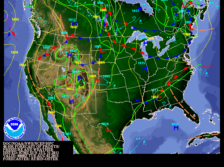
Tomorrow will be more humid as our flow turns into the SW. As a result, the higher dewpoint air will move into our area ahead of a cool front poised to move through late Monday/early Tuesday. As a result, there will be a slight chance of thunderstorms Monday afternoon, but nothing too out of the ordinary for August! The surface map below shows the location of the front for Monday night. That will bring in drier air for Tuesday. Frankly, this week is rather uneventful around here weather-wise. Just a typical mid-summer spell of weather with nothing extreme. Temps will tend to be on the slightly higher side of normal thanks to global warming....cough, sigh, gag, choke!
Now I will shift to soon to be named Emily. I would believe that by the 5 pm update on Sunday, tropical storm Emily will officially exist. The IR satellite pic clearly shows the clouds beginning to do their dance in the SE corner of the map. However, you only have a snapshot of the central, dense overcast that will soon develop closed rotary circulation that the movie of the satellite indicates. I tried unsuccessfully to clip movie loops of the satellite pics, but the blog site doesn't really like the amount of digital data it requires. Not sure why?
I still believe as of this morning that this storm will pass over or just south of Puerto Rico Tuesday night/Wednesday morning. There are several models that study these tropical cyclones. This particular model shown below shows Emily making a direct hit on Puerto Rico with minimal hurricane status or tropical storm status. I made this graphic a bit larger for closer analysis. Take a look.....
Please also understand that there is still considerable spread amongst the modeling community. Here are the latest forecast tracks for the next several days of this yet to be named storm.
In closing, as I thought, Hunter Pence received a huge ovation upon running into his right field position and when announced for his first plate appearance as a Phillie. The crowd was still buzzing after Ryan Howard popped a big fly to dead center when Pence made his 1st plate appearance as a Phillie. This is certainly one of the reasons the Phillies traded for Pence. Howard should see a few more pitches that are to his liking. Then the real fun began when Pence grounded a ball up the middle. The throw to 1st base caught umpire #55 Angel Hernandez off guard. So what else is new? He completely blew the call as Pence beat the throw by a good half stride. Much to the credit of Pence he simply turned to the dugout in a most professional way expressing his displeasure with the call in quite a restrained manner. Charlie, however, let Hernandez know in no uncertain terms that he blew that call and that he is well, #55! Maybe Meals and Hernandez should get together for some umpiring clinic in the off season....or better yet...retire from the game!
Have a good Sunday and keep the eyes to the tropics.
Smitty
AA: Nice weather Sunday, more humid Monday with maybe some storms, nice again Tuesday with lower humidity. Pence will most certainly help the Phillies in numerous ways.
Subscribe to:
Posts (Atom)