The weather today will be nearly a carbon copy of yesterday albeit with slightly less wind which will make the day feel warmer. When i walked outside this morning, it was by far the most refreshing early morning in quite some time! The satellite pic shows the abundance of clear skies in the PA area as a large bubble of high pressure sits over PA today.
The surface map below shows nicely the high pressure literally right on top of PA. As I mentioned yesterday, under the strong July sun, some cumulus will build later this afternoon only to make today a very picturesque day in central PA.
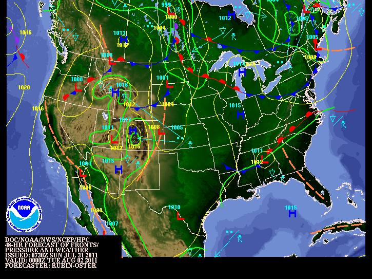
Tomorrow will be more humid as our flow turns into the SW. As a result, the higher dewpoint air will move into our area ahead of a cool front poised to move through late Monday/early Tuesday. As a result, there will be a slight chance of thunderstorms Monday afternoon, but nothing too out of the ordinary for August! The surface map below shows the location of the front for Monday night. That will bring in drier air for Tuesday. Frankly, this week is rather uneventful around here weather-wise. Just a typical mid-summer spell of weather with nothing extreme. Temps will tend to be on the slightly higher side of normal thanks to global warming....cough, sigh, gag, choke!

Now I will shift to soon to be named Emily. I would believe that by the 5 pm update on Sunday, tropical storm Emily will officially exist. The IR satellite pic clearly shows the clouds beginning to do their dance in the SE corner of the map. However, you only have a snapshot of the central, dense overcast that will soon develop closed rotary circulation that the movie of the satellite indicates. I tried unsuccessfully to clip movie loops of the satellite pics, but the blog site doesn't really like the amount of digital data it requires. Not sure why?
I still believe as of this morning that this storm will pass over or just south of Puerto Rico Tuesday night/Wednesday morning. There are several models that study these tropical cyclones. This particular model shown below shows Emily making a direct hit on Puerto Rico with minimal hurricane status or tropical storm status. I made this graphic a bit larger for closer analysis. Take a look.....
Please also understand that there is still considerable spread amongst the modeling community. Here are the latest forecast tracks for the next several days of this yet to be named storm.

In closing, as I thought, Hunter Pence received a huge ovation upon running into his right field position and when announced for his first plate appearance as a Phillie. The crowd was still buzzing after Ryan Howard popped a big fly to dead center when Pence made his 1st plate appearance as a Phillie. This is certainly one of the reasons the Phillies traded for Pence. Howard should see a few more pitches that are to his liking. Then the real fun began when Pence grounded a ball up the middle. The throw to 1st base caught umpire #55 Angel Hernandez off guard. So what else is new? He completely blew the call as Pence beat the throw by a good half stride. Much to the credit of Pence he simply turned to the dugout in a most professional way expressing his displeasure with the call in quite a restrained manner. Charlie, however, let Hernandez know in no uncertain terms that he blew that call and that he is well, #55! Maybe Meals and Hernandez should get together for some umpiring clinic in the off season....or better yet...retire from the game!

Have a good Sunday and keep the eyes to the tropics.
Smitty
AA: Nice weather Sunday, more humid Monday with maybe some storms, nice again Tuesday with lower humidity. Pence will most certainly help the Phillies in numerous ways.


No comments:
Post a Comment