Look at these absolutely hellacious temperatures as of 3 pm local time for the south central plains! Uuugh!
As for us here in PA, it was a glorious Tuesday weather-wise as a stiff NW wind ushered in dry air albeit with temps near 90F once again. As the satellite picture shows, the high cirrus that you observed in today's sky is the precursor of tomorrow's weather situation which has some unique dynamics associated with it for this time of year.
The complex of clouds over WI and MI will be quickly moving SE with a jet stream disturbance or shortwave or vort max or whatever your pleasure towards PA overnight tonight into Wednesday. The forecast problem is to pinpoint just exactly where that shortwave wants to track and then we can isolate the areas of heaviest rainfall. The NAM has been the most consistent model with this mesoscale system placing its heaviest rain just to the NE of our immediate area. Northern PA into the Poconos and onto N Jersey looks to be the winners of tomorrow's rainfall based strictly on the modeling. I believe, however, that the band of heaviest rain will still fall somewhere along the spine of the Appalachians as orographic effects from the easterly flow will assist in the upward motion to create heavier showers into central PA. We could even experience some rather gusty storms in the max heating time of the day! Time will tell! I did attach the NAM precip model output for the period ending Wednesday morning.
The model also confirms its path of the heaviest rain by confirming the coolest temps in that area as well as seen below. Much of northern PA appears to remain in the 60s tomorrow where the Arklotex region exceeds 100 for its 32nd straight day this summer! Ouch!!!!
Now onto Emily....She must be watched as there is still much spread among the models as to the final outcome of this hurricane. As of this post, Emily is far more organized than the double barreled storm of yesterday. You can clearly identify this as a tropical weather system as seen from a visible satellite pic as of 3:15 pm EDT. Since it took longer to develop, Puerto Rico will be spared but unfortunately, this grief stricken population of Haiti will not be. This storm appears that it will pass directly over Hispaniola and then migrate towards the Bahama-mamas. Most of the modeling steers it offshore of the east coast of the USA, but I'm not completely sold on that solution as of this time.....for what that is worth!
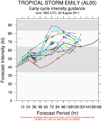
The strengthening of the storm does seem to be tempered as it will interact with the rather large island of Hispaniola and some of its thermodynamics will be stolen by the land area. Here is the numerous spreads of both the strengthening of the storm and the potential paths as modeled by the computer equations. Most of the modeling has at least a Cat 1 storm within 2 days from now....but there is tremendous spread....no consensus!
Here are the various tracks as depicted by the modeling:
In closing, I am sorry that I've been late with these posts the last few days as I've finally been able to relax this summer and do things at my pace! I know that sounds insane, but it takes me a while to unwind from the school year and get into "summer mode"! So understanding that today was going to be a beautiful day to tromp through Penn's Woods with Kay and Ziggy and Zola, it was off to the Chambersburg Reservoir for a quick hike and a long swim. The gusty NW wind created ample chop on the water to remind me of days gone by in New England! The cirrus reminded me of tomorrow's impending weather event....I hope.....and the serenity of the Michaux Forest reminded me of just how lucky we are living in this great country and being grateful to have the opportunity to commune with nature and my loved ones including the 4 legged ones!
Have a great Wednesday!
Smitty
AA: Looking for rain on Wednesday...the models say more northeast of here, I say HERE! Also, continue to monitor the tropics. Miami, FL is not out of the woods as of yet!
PS: I added a National Weather Service glossary to the right sidebar as per a request of one of the readers. I hope this is helpful for those of you that have a curiosity about this fascination known as meteorology!


No comments:
Post a Comment