Concerning this weekend's upcoming and impending strong east coast cyclone, I am siding with the foreigners on this one. Too many times the American modeling progresses systems too quickly and doesn't allow for a full fledged cyclogenesis to occur along the natural baroclinicity of the eastern seaboard. With the upper air features just now getting to the North American continent, I believe the GFS by the end of today will begin to spin up quite a doozy along the Mid-Atlantic coast and pummel the east coast with gale forced winds and copious amounts of rain late Saturday evening into early Monday morning. A storm of this intensity is rather rare for this late into the season, but most of the global modeling is suggesting just that.
Lets take a look....1st the GFS for Sunday...a front has passed through PA without any phasing and the storm develops too far off the coast...swing and a miss!
Here is the NAM...similar scenario with disjointed storm formation too far east to truly affect us here in PA.
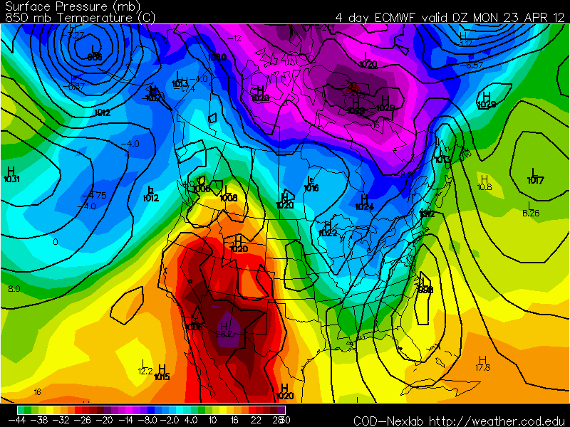
Now onto the European...It shows a 996 mb low deepening off the Carolina coast with the upper level cold advecting rapidly into the storm as shown by the blue colors...
And here is the "bomb" it develops within 24 hours! Kaboom! This would give snows to northern PA up through the Adirondacks and into northern NE! For us, we'd be looking at wind swept rains totaling 1.5-2.5" by Monday morning.
Even the UKMET has the same potential...although I can only go out 72 hours for the modeling...
So time will tell, but I do believe the truth lies somewhere in between...that is why it is called guidance. The GFS is too dry and progressive while the extreme Euro is a bit too extreme...yes....even for me!
And speaking of extreme...10-3 final in a Stanley Cup playoff game! Wow! That's what happens when you think you can take a night off...or at least not give 100%! And out on the west coast, Cain and Lee pitch 19 scoreless innings, give up 9 hits, 1 BB, SO 11, and have nothing to show for it! I believe this might just be a precursor of things to come for the listless Phillies...oh well!
Have a good Thursday!
Smitty
AA: Nice through Saturday morning, increasing clouds by Sat evening with a few showers, but looking for a major wind driven rain event for Sunday! Cold to follow for a couple of days.....


No comments:
Post a Comment