Now onto Altoona and the PIAA AAAA semi-final in the sport of football. Ironically, it will be the coldest day of the winter, although it will not be as brutal as it could be for the second Saturday in December...BUT IT WILL BE COLD! Here are the progged temps for 7 pm Saturday evening...
Winds should slacken as the sun departs under the SW horizon, and only a gentle WNW flow of air will be experienced during the game.
The upper atmosphere supports a building high pressure system at the surface as the isobars are converging from the west over the Mid-Atlantic. Note how the isobars tend to flow towards each other over PA as opposed to where they diverge over the inter mountain west. Upper air convergence supports surface high pressure.
And here is how the surface map will appear for Saturday afternoon. Clear sailing and driving to and fro Altoona a piano for 50 cents!
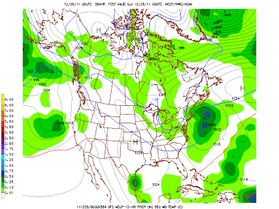
Looking forward to Christmas...a trough digs into the eastern part of the US. If this is just a slight jog to the west, we will be looking at the potential for a White Christmas.
Here is the surface expression above the above upper level pattern. Go west ye ol' trough...go west!
Just doesn't look right...does it?? Maybe the Angels should be bailing out CA and not the Dominican Republic!
Enjoy the weekend and GO RAMS!Smitty
AA: Sorry on the bad call for the snow...about as good as Michael's and mine fantasy FB team. Clear and cold weekend.


No comments:
Post a Comment