Saturday, November 5, 2011

Winter's White Carpet Slowly Creeping South

After an invigorating brisk walk with my lovely wife this crisp, clear, and calm glorious autumn morning with Orion staring down at us, I decided to come back and see if any of the preliminary maps from the "freak" October snowstorm were posted yet from the NESIS (northeast snowfall impact scale) website.  Sure enough on this beautiful sunny Saturday morning, just one week following the onset of our anomalous October snow, the map was posted.  I thought I would share this with y'all who might be interested.
And, as many of you know, I got lost with the websites and their embedded links that are available which remotely sense our planet.  Here is the latest snow and ice cover slowly creeping south from the north polar region as the sun continues to lower its diurnal sun angle until the winter solstice.  First, a north polar view of the snow and ice cover.
And now the close-ups...1st of the USA...
NW O Canada and Alaska...
Lastly, northern Eurasia...
Now when I looked at these graphics, I thought to myself that this seemed to be a rather widespread area of snow and ice for this early in the cold weather season.  So I researched snow cover anomaly online and found this...from the Rutgers Global Snow Center and the Florida State Univ locally produced web pages.  It now appears that we are essentially "normal" in snow cover as the blue (observed) fits closely with the green (climatologically normal); maybe a bit more expansive in Asia and less so in North America.
Here is a graphical representation from the last 4 months...


You can clearly see a few cold shots in mid September and then again around the 1st of October increased the white carpet and most recently with the widespread October snow event as shown above with the 1st map!  Most of October was lacking in snow cover when compared to normal.  So what does all of this really mean?  Who knows???  One thing for sure...it will most certainly be blamed on Global Warming!

Enjoy your Breeders' Cup & NCAA College football Saturday!

Smitty

AA:  Just some data that scrutinizes snow and ice since we are getting closer to winter! 

What Time Is It?

With the weather being so non-eventful at present, and the weekend that so many have a love-hate relationship with is upon us, that being the onset of standard time (and an extra hour granted to us by...??), I thought I would discuss time this time while contemplating the wonderful November wx that will be ours to enjoy for the upcoming several days of time.  Look at the cloud free satellite shot over the country and the sprawling area of high pressure as per the surface map.
Here is the current surface map and the huge area of clear sky; fine sailing wx for any atmospheric interest.

So the wx is clear, cool, very dry....can't you tell with all of the static electricity in the air?  My oh my, I must have been lit up at least 10 times yesterday afternoon & evening thanks to donning my winter woollies for the East High football game.  So lets briefly discuss Time here this morning.....since the wx has little need for discussion over the next several days; although a 70ºF day for election day would merit some discussion.  But this weekend, specifically this Sunday morning at 2:00 am EDT, we will turn our clocks back one to then 1:00 am EST.  As was told by a classic educational film produced by Bell Laboratories from 1962, we learned in "About Time" it can be whatever time you want it to be.  Just set the time keeping device and keep it there, until all agree to change it to whatever time you'd like to change it to!  So, this weekend, we as a society are moving back to standard time from savings time.  Unless you live in Hawaii, American Samoa, Guam, Puerto Rico, the Virgin Islands or the state of Arizona (but not the Navajo Indian Reservation, which does observe DST). Thanks to a recent act of congress, we now switch our clocks on the 2nd Sunday of March and the 1st Sunday of November at 2:00 am.  I for one will have my internal clock messed up for many days hence.  Here is a map of our standard time zones across the US.
Each time zone is roughly 15º wide longitudinally thanks to the rotation of the earth.  The 75th meridian west of the Prime Meridian marks the center of the Eastern Time Zone.  Then, add 15º for each subsequent zone across the US.  Thanks to the US rails, we now have standard time zones.  You see, train schedules were kept by local time keepers based on the solar time...different type of time, which led to much confusion.  To keep it simple, since Pittsburgh is west of Philly, the sun rises there later....20 minutes later to be precise.  Take a look in your hunting guide for the shooting times which are based on sunrise/set times across the state.  Here's the map....

The sun rises 20 full minutes later in steel city as opposed to the city of brotherly love.  Since Pittsburgh is 5º west of Philly, and the sun rises 20 minutes later, that equates to ~4 min/degree of longitude. Due to the earth's rotation, that is how much the celestial objects move in the sky...including the sun.  Thus everyone has a different solar time if they are located on a different meridian.  So, thanks to an act of Congress in 1918, all of the US adopted standard time zones that was in use by the railway systems in U.S. and O Canada since November 18, 1883.  The use of standard time gradually increased because of its obvious practical advantages for communication and travel. Now that Congress has created the Department of Transportation in 1966, time zone tinkering has become their puppy.  This is crucial, unless of course you have a smart phone which will tell you the time anywhere in the world which is kinda neat and you don't have a life like me and simply wonder about these things from time to time....no pun intended!  Here is the daylight distribution over our earth as of this writing.....
Or maybe you prefer this more hi-tech version thanks to an iPad app.....the circle of illumination is clearly 2 hours+ east of the east coast of the US.  The blue dot marks my locale.

So by looking above, the noon time position is somewhere through the Middle East, the eastern Mediterranean, and eastern Europe, approximately where the bisecting north-south line would split into 2 equal portions the daylight distribution from the top picture.  We can look at a world time zone map and see how close our approximation was geographically using that rudimentary approximation.  Seeing that it is ~ 5am here or ~ 7 hrs shy of "noon", then we would look for a time zone that is 7 hours ahead of us here in the eastern US!

I could go on and on as most of you know (different stories for different days), but I'll stop at this point and simply share with you one of my favorite ditties about Time.  It comes from Pink Floyd's classic "Dark Side of the Moon" album from 1973, where within one week sprinted straight to the top of Billboard's top albums and remained in the top 100 for 741 weeks from 1973-1988, arguably the most successful music album of all time!  One of my favorite, albeit somewhat depressing poems, comes from this album appropriately titled...."Time".  Here are the lyrics....

Ticking away the moments that make up a dull day
Fritter and waste the hours in an offhand way
Kicking around on a piece of ground in your home town
Waiting for someone or something to show you the way

Tired of lying in the sunshine staying home to watch the rain
And you are young and life is long and there is time to kill today
And then one day you find ten years have got behind you
No one told you when to run, you missed the starting gun

And you run and you run to catch up with the sun, but it's sinking
Racing around to come up behind you again
The sun is the same in a relative way, but you're older
Shorter of breath and one day closer to death

Every year is getting shorter, never seem to find the time
Plans that either come to naught or half a page of scribbled lines
Hanging on quiet desperation is the English way
The time is gone, the song is over, thought I'd something more to say


Then....Breathe Reprise....

Home, home again
I like to be here when I can
And when I come home cold and tired
It’s good to warm my bones beside the fire
Far away across the field
The tolling of the iron bell
Calls the faithful to their knees
To hear the softly spoken magic spells


And here is the song!
Enjoy your hour longer than normal  weekend...which will allow us to contemplate the 1st round match-ups of the PIAA District 3 AAAA football; namely East High vs CD next week. 

Smitty

AA:  Nice weather and a great song along with the poem about time!


Thursday, November 3, 2011

Spell of Nice Wx

I hope everyone is now enjoying this spell of outstanding fall weather with clear, crisp mornings moderating to beautiful afternoons.  Many do not realize that our morning lows the last few days have been within only a few degrees of KMDT's record minimums.  But, true to form with dry air, a large diurnal temperature range has been the play with temps moderating to above normal the last 2 days.  Now Friday Night Lights is upon us and the wx will cooperate once again in our area.  However, temps will be noticeably colder Friday when compared to the last couple of afternoons.  The storm system to our west will be suppressed with a dome of cool high pressure moving SE towards New England.  The blue arrow shows the advection SE of the Canadian High Pressure whereas the red arrow shows the progged movement of the vorticity clearly seen as a comma shaped storm over the mid-section of the US. 
Friday will dawn cloudy, but by kickoff, skies should clear and once the sun sets, radiational cooling will quickly take center stage.  Temps will drop into the low 40s by kickoff and into the upper 30s by games' ends.  Here are the forecasted temps for 8 pm Friday night.  CD should have comfortable lead over Chambersburg by that point....and working their way to the potential of having the #1 seed in District 3!
The colder temps will be ushered in by winds ejecting straight from the north as seen below.
I believe Saturday will be a colder day than being presently forecasted by the TV mets.  With cold air at all levels and the ground still quite wet, the bright sun will have a difficult time warming the lower layers as efficiently as the rip and readers are buying.  Personally, if we hit 50F Saturday, that will be a bonus!  Here are the 850 mb temps for Saturday.  Admittedly, the cold air aloft is vacating PA, but it will be difficult to erode due to the lowering sun angle at this time of year.
However, by Tuesday, temps will moderate and actually feel quite balmy as opposed to what we've recently been experiencing.  It's not out of the question that we could tickle 70F come Tuesday afternoon!
The GFS ensembles are bullish for the warm-up as well as shown by the 500 mb anomaly below.  The warm bulls-eye is sitting right over us!
Now, by later in the period, say next Sunday, the flow according to the GFS is still southwesterly.  The deep trough is still focused into the western US.  This should provide "mild" temps for all of next week.  Take a look....
However, the Euro doesn't buy that solution.  And let's remember what the Euro did for us last weekend.  So once we get out to 10 days, the modeling begins to diverge.  Thus, tread softly when listening to prognostications beyond the middle of next week.  As most of you know, I tend to side with the Euro in the medium range.  That weak trough spells some potential trouble for a nice weekend for next weekend.
But this weekend will be spectacular, albeit a bit chilly Saturday for our immediate area.  Sunday looks to be awesome.  So when our Lady Ram Field Hockey team is competing for a state tourney bid Saturday morning at 9:30 am at Hershey High School, the bright sunshine will help take the sting out of the morning chill.  But if you fancy college football and your focus is the 'Bama-LSU tilt, the wx for the kickoff set for 7 p.m. at Bryant-Denny Stadium in Tuscaloosa should be wonderful; calm winds under clear skies and temps right around 60F!  The game will be televised nationally on CBS with a the potential of being one of the most watched college football games ever!  Go 'Bama!
But prior to that matchup, maybe you can catch a race or two from Churchill Downs for Saturday's Breeders Cup Classic event.  High pressure promoting sunny skies and temps in the mid 60s will rule the roost in Louisville this Saturday.  So for your 6:15 pm post time appetizer for the NCAA clash, it might be as easy as ONE-TWO-THREE in your exactas and triples.  Although Harve de Grace is a she, this filly should hold he own and be there near the wire with both Flat Out and Uncle Mo!  Personally, I believe that Flat Out coming out of the 2nd Post Position has an advantage over the other two as they are coming out of the 10 and 12 holes.  Thus, put Flat Out on top of Uncle Mo and Harve de Grace and you'll be able to parlay those winnings into 'Bama laying the points and soundly defeating the Tigers by at least a TD!  I know.....I know.....stick to the wx!
Have a great week's end!

By the way, I believe PSU will cover the "Bye" this weekend!

Smitty

AA:  Nice wx, but a bit chilly Saturday.  Getting warmer through mid-week, could even touch 70 Tuesday!  Then it becomes a bit murky as the modeling is inconsistent for next weekend.  Looking forward to some good NCAA football Saturday evening after the ponies run Saturday afternoon!

Saturday, October 29, 2011

Storm is Winding Down

But we will have one last burst of snow as a deformation band sets up somewhere near the Lower Susquehanna Valley as the storm begins to pull north and east.  Thunder-snow was reported around the 1 pm hour in the Harrisburg area and visibilities are less than 0.5 mile for several hours this afternoon.  Here is a visible satellite image of the storm....note the bubbly clouds that are precipitating heavily and the "eye" that is trying to develop in the "snow-cane" that we experienced here today!
And here is the IR satellite image showing the classic comma shape for this incredible cyclone.  The pressure of this system should attain ~992 mb or lower at the 40th parallel!  It will deepen further as it pulls away and thus winds will strengthen overnight. 
The NWS office at State College has added some new graphics for wx obs over the past couple of days.  Here is the visibility observations over the last 2 days.  Note the lowering ceiling and low visibility during the height of the storm.  Note how the last hour obs the visibility is improving; how depressing!  As of 5 pm, KMDT has received 1.38" of liquid creating our 5" snowfall.  Doing the math equates to ~4:1 ratio; a very wet snow!  Do keep in mind that ~0.25" of that liquid fell prior to the changeover to snow early Saturday morning.
Here are the modeled winds for just before midnight.....
And here are the forecast lows for Sunday morning...quite a cold morning for October 30.  The previous record minimum is 24F in 1965.  We will be close and should get to it the skies clear out by say 3 or 4 am.  The winds would also have to abate.
This storm's impact will be affecting many people over the next few days.  It's one thing to lose power when temps are mild or even warm; its another story to lose electricity when temps are in the 20s at night!  Here is a county by county count of service outages for both PPL and Met-Ed as of 5 pm! 
And Met-Ed's site was overwhelmed for part of the afternoon!  Trust me, there were over 10,000 outages in York County alone as of 2 pm.  I hope y'all can read this and therefore have not lost power!
Well as the storm winds down (as of 5 pm, KMDT has officially received 6.0" of snowfall), I will settle back in front of the TV to view a punting clinic and turnover delight from State College, PA under the guise of a Big Ten football contest!
Enjoy the remainder of your weekend.

Smitty

AA:  A record breaking snowstorm for October 29!  I hope you guys don't lose power!  Be safe if you venture out and turn off the water!

Impending Disaster??

I know, I know...Mr. Chicken Little coming to y'all live from Etters, PA!  But if what the modeling is suggesting verifies, south central PA will have bestowed upon it from mother nature some of the worst possible weather conditions for this time of year.  With heavy wet snow, the weight of the snow will easily bring down trees and power lines and large scale outages WILL occur!  With that said, just prepare yourselves with the potential of losing electrical power for at least 24 hrs as what the modeling is now suggesting is simply a recipe for disaster.  I do not want to overstate my position; however, I most certainly do not want to underestimate what I believe could be a crippling event for the south central region of PA!  The 1st map I'd like to show is where the NAM believes the heaviest snow will accumulate.  Note the areas where the lowest temps are being shown on the map below.  One can extrapolate that this is where the greatest amount of snow will be lying on the ground as of Sunday evening late.  28F isotherm is essentially bulls-eyed over Lancaster County!
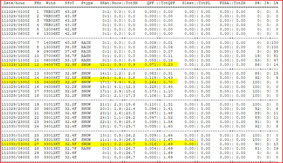
Now let's see if the NAM is correct.  Here is the literal output from the NAM.  I highlighted 3 areas; the total snowfall, the beginning of the snowfall, and the heaviest snowfall rates.  Remember for those of you who want more than the AA, you can click on the graphic and it should get larger for your viewing pleasure!
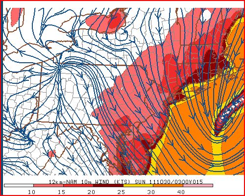
Wind is also a real concern especially with the weight of the snow.  Here is a map showing the winds and the location of the low as of 10 pm Saturday night.  I don't think this is what the Bay City Rollers had in mind with their hit classic from 1976 (#1 on Billboard's hit list!).  That is quite a nor'easter!  At this point, cold air, from all levels, will be drawn towards the center of the low just off of NJ coast by less than 100 miles!  Quite the gale center to be sure.
And the Euro most certainly agrees!  I believe places like Mt. Pocono could receive upwards of 2' of snow when all is said and done. 
So let's see how all of this plays out.  If the NAM is correct, it could get ugly around here for the bulk of the weekend even though the storm is past just after nightfall.  Winds will be gusty knocking down trees and power lines.  Then, unseasonably cold air will be entrenched for the next couple of days.  But, good things come to those who wait.  As you can see below, temps will moderate to above normal if the modeling verifies and the upper air pattern is as shown by the Euro for late in the upcoming weekend and early first full week of November.
So I wish I could bring you better news....but unfortunately, this is what I am seeing.  I believe this could be an historic event; a once in a lifetimer meteorologically.  Please remember that climatologically, the sun angle is comparable to mid February, and we can recall some of the infamous President Day storms over the years.  Yes, the ground is warm, and the lower troposphere is just coming off of summer, but with the strength of the storm and the dynamically lifted air, we are going to see snowfall of unprecedented proportions with this nor'easter.  I marked with a blue "X" where the storm appears to be early this Saturday morning.  Note the 25 kt winds just north of HSE!

In closing, I'd like to acknowledge that for the 2nd year in a row, the Phillies lost to the eventual World Series Champs.  Being a National League MLB fan, (I despise the DH in the AL!), I am very happy for the St. Louis Cardinals as they played like champions for the last month of the season.  Had it not been for the Phillies hammering the Braves at the end of the regular season, St. Louis would not have even been invited to the postseason parade for 2011.  As fate would have it, the Phils pound their nemesis, and lose to their replacement.  Isn't it Ironic; don't ya think?  So a big congrats to the Cards and their fan base which does run deep across the country as witnessed by the hats and shirts seen sported in these parts the last few weeks.
Enjoy this ditty about St. Louis, Missouri and your week's end...and be careful out there!
Smitty

AA:  My best bet is ~8" officially at the airport by nightfall when the storm is essentially over and moving rapidly up the coast.  It should changeover by 10 am and snow will fall heavily for several hours through the afternoon.  Thunder snow is also a real possibility with this rapidly deepening storm.  Power will be out for many for several hours.  I ACTUALLY HOPE I AM WRONG WITH ALL OF THIS!!  Then, clearing and a bit blustery yet Sunday and COLD for this time of year.  Temps will moderate and the pattern will settle for early in the upcoming week as another storm appears to just miss us Tuesday-Wednesday just off to the east.  Then watching yet another storm (warmer) for next weekend, but the Euro says no at this time (as does the Japanese model!)  Have a good weekend my friend!

Thursday, October 27, 2011

But It's Only October!

As most of you know by now, I love the winter season and snowstorms in particular.  With that said, I'm still hesitant to call for what the major modeling from around the globe have trended towards for over a week now....all except the lovely American GFS.  After this morning's run of the Euro, I felt a little more confident that a real potential exists for an early season, possibly once in a lifetime historic snowfall for our region.  After seeing the 12Z Euro and the finally the GFS, I am now quite confident that snow will fall in our area and accumulate several inches very quickly during the daylight hours of Saturday.  Most of the accumulation will be on non-paved surfaces, but therein lies the problem.  With gusty winds, a heavy wet snow accumulating on trees and power lines WILL DO SEVERE damage if this snowfall verifies!  Here's the Euro for Saturday evening...
And here is the GFS for the same time...
They look fairly close in their agreement!  Here is a quick look at the plumes for KMDT.  Note that most of the ensembles are all snow and the average amount of precip is over 0.6 inch!  Even at 5:1 ratios, we're looking at 3 inches of heavy wet snow on grass and trees!  Couple that with wind and we've got some issues.  Look for greater accumulations in the higher terrain of our region!.
Here is the NAM's snowfall ending Sunday morning.  That is quite a snowfall.  I believe the heaviest belt will be west of where the NAM algorithm has it located.  This is unreal....I wish it were January, I wish it were January....
As for Friday night lights, look for mostly clear skies with some high cirrus moving in as a precursor for Saturday's event.  Winds will be gusty during the day, but once the sun sets, they should abate and temps at kickoff should be in the mid 40s; nice fall football wx!  Take a look at the progs for temps and winds for Friday pm....

And now winds...
So there you have it...October's version of a nor'easter coming to the Mid-Atlantic.  For some a trick; others a real bona fide treat!


Have a great Friday!

Smitty

AA:  After a nice, but coldish Friday, watching a nor'easter crank for Saturday with limb busting snows on foliated trees!

The Euro is a Hit

A hit along the eastern seaboard with coastal rains and inland snows that would actually accumulate of grassy surfaces and trees and powerlines.  The water content would be quite high and it could actually be quite an ordeal somewhere between northern MD and ME.  Here is the latest run from the Euro...it is quite a storm with ample cold air entrained to do some serious wintery precipitating!
As for the middle of next week, the Euro takes the remnants of Rina too far east to deliver any heavy rain to our region...and that's not a bad thing.  I'm just not convinced yet that will be solution, but it looks like Rina's remnants will be a swing and a miss!
Have a good Thursday!

Smitty

AA:  None needed this am.