And here is the GFS off run at 06Z...
Here is the print out so to speak for the Euro's run overnight last evening...0.1 inch liquid at 20:1 would produce a fluffy 2" snow event. Tomorrow's evening's commute might just be a nightmare scenario that played out this am for anyone who traveled I-83 Thursday morning with a whopping 0.2" snowfall!
After a brief warm-up next week, the month of February looks to be quite cold if you believe the climate forecast system version 2 modeling...below is a map from the last 10 days' runs hinting at a cold and stormy last month of winter.
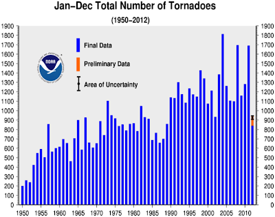
OK...gotta run...can't wait for our massive Flizzard For Friday...otherwise known as F3...no... not tornadoes, but speaking of tornadoes, our preliminary report was quite low for last year's severe wx reports, especially tornadoes! Sorry....I digress.....
Enjoy the remainder of your Thursday!
Smitty
AA: 1-3" snowfall Friday afternoon making the Friday evening a commute a potential nightmare in these parts! Another snow/ice event next Monday (LIGHT) prior to a brief warm up for middle of next week. Then cold (and potentially snowy) for February!

.png)


