Saturday, December 10, 2011

'Twas the Week Before Christmas

Just a very brief post to alert y'all that the American modeling is hinting at a period of unrest for the atmosphere the week before Christmas.  As we move deeper through December, the average temps decrease compliments of a lowering sun angle and a shortening day.  Couple that with increased snow cover over North America and the winter season will be upon us very quickly the next several weeks.  Here is the current snow and ice coverage over North America.  Note how the Chinook (down-sloping and warming winds on the east side of the Rockies) helps clear snow in the Canadian prairies and in our plains states as well.
This week will feature tranquil weather compliments of an upper air ridge and surface high pressure for the bulk of this week.  That is a rather extensive upper ridge extending out from the Gulf of Mexico and flexing its muscle all the way up into New England and Ontario.

But lurking back in the SW USA is that pesky trough that will start to send pieces of energy out eastbound.  The first possible threat is next weekend as a weak wave passes off to our south.
I believe yet another boundary or front will set up as shown where the green precip is falling and waves of low pressure will spin up along that boundary subsequently pulling colder air towards the SE states.  The modeling hints at a second wave that is getting some energy as shown below.  This is later Monday of next week.

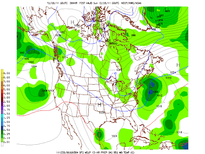
Then comes the dandy; the "Big Dog" so to speak...ruff, ruff!  High to the north, low pressures in the southern states, a digging upper trough and we may just, just might have a White Christmas.  Hello, bingo front row!  Be aware, this could also as easily not even materialize or pull much further west based on where the boundary decides to set up shop.  After all, this is 11 days hence.
Just for kicks and giggles and for the sake of climatology. Here are the statistical averages of seeing snow on the ground for December 25.  Living in the Koeppen sub-tropics, we experience snow on the ground in late December about 1 out of every 5 Christmases, not very good odds!

So kick back, relax, and enjoy this holiday classic as we prepare to celebrate this 2011 Christmas season.  This weekend's briskness (coldest days for the last 21 at KMDT!) will help get your weather spirit going, unlike my blown call for a plowable storm earlier this week...it hurts will continue to hurt for quite awhile!
GO RAMS!

Smitty

AA:  Tranquil week upcoming, but unsettled with snow possibilities the week before Christmas.  Good chance for the CD RAMS to be playing at Hershey next weekend....in a snow event???!!!


Friday, December 9, 2011

Looking Back & Looking Forward to Football

Hey...I did think the cold air would arrive in spades once the storm began to bomb out southeast of us, evidenced by the thunderstorms that rolled through around 8 pm.  However, there was just too much warm air to erode to kick the precip over to snow fully and give an appreciable accumulation.  Places at elevation did receive accumulating snows just to the north of Harrisburg.  Here's the satellite view of where snow was on the ground as of early Thursday.
Now onto Altoona and the PIAA AAAA semi-final in the sport of football.  Ironically, it will be the coldest day of the winter, although it will not be as brutal as it could be for the second Saturday in December...BUT IT WILL BE COLD!  Here are the progged temps for 7 pm Saturday evening...
Winds should slacken as the sun departs under the SW horizon, and only a gentle WNW flow of air will be experienced during the game.
The upper atmosphere supports a building high pressure system at the surface as the isobars are converging from the west over the Mid-Atlantic.  Note how the isobars tend to flow towards each other over PA as opposed to where they diverge over the inter mountain west.  Upper air convergence supports surface high pressure.
And here is how the surface map will appear for Saturday afternoon.  Clear sailing and driving to and fro Altoona a piano for 50 cents!

Looking forward to Christmas...a trough digs into the eastern part of the US.  If this is just a slight jog to the west, we will be looking at the potential for a White Christmas.
Here is the surface expression above the above upper level pattern.  Go west ye ol' trough...go west!
Just doesn't look right...does it??  Maybe the Angels should be bailing out CA and not the Dominican Republic!
Enjoy the weekend and GO RAMS!

Smitty

AA:  Sorry on the bad call for the snow...about as good as Michael's and mine fantasy FB team.  Clear and cold weekend.

Wednesday, December 7, 2011

Snow Rates Should Be 1"+ This Evening

In our immediate area, we should see snow rates at 1"+ for a few hours as the storm really cranks just to our ESE.  I've quickly attached 2 maps.  The first shows the surface freezing line (hot pink) and the storm "bombing" off to our east.  This will pull the cold air very rapidly into our region at all levels.
The 2nd map is the 3 hr precip ending at 10 pm this evening.  Most of this will fall as snow according to the short term modeling.  The dark black line is essentially the rain snow line.  So if you're up around midnight this evening, mom nature could be offering quite a show complete with some thunder and lightning!
And if you are up after midnight...enjoy this classic!  Please, feel free to hoot and holler right along with the gang!

Enjoy your Thursday!

Smitty

AA:  Still looking at some briefly heavy snow once the sun goes down.  Changeover by 9 pm I'd say.

Rain Then Snow

Just a very quick post now that the storm is upon us...and it now appears that a moderately heavy rain event will evolve into a moderately heavy snow event.  The sooner the storm strengthens, the more rapidly cooling will be able to occur not only at the surface, but where the snowflakes are produced in the cloud.  To be sure, this is a much greater event in terms of precipitation than most people saw coming as evidenced by the flood watch statements.  If this warm air from the last week were not in place, we'd be looking at a major snow event for early December.  As it is, we are looking at a 3-6" event in our area with the bulk of it falling during the sun down hours.  So if driving, don't be fooled by the statements that the roads are "warm" and snow can't accumulate on them.  When snow is thumping at 1"+/hour, driving will become tricky overnight tonight...so take caution.

I am posting just one image and that is from the ensemble plumes.  I circled in red where the changeover time seems most likely (lines go from green to blue) and placed a mark at the time scale along the bottom axis.  That is somewhere near 22-23Z or 5-6 pm this evening.  It also appears that it is about halfway along those colored lines so lets say half falls as snow and half falls as rain.  If that is the case, then at 10:1 which is what the models are suggesting for the snow, and accounting for some melting due to the recent warmth, we are looking at 3-6" from 6 pm until 3 am or so...slightly higher amounts with elevation along the Blue Mountain up into northern Lebanon County and the high ground of western York and Cumberland Counties. 
Now where can you get that type of analysis for free.....I know, I know.......just about everywhere and anywhere on the internet...but you need to go no farther than Smitty's Synoptic Synopsis!

Go Rams and D3 football!

Have a wonderful Wednesday!

Smitty

AA:  Heavy rain changing to heavy snow around sunset or just after. 

Tuesday, December 6, 2011

Moderate Snow Wednesday Night into Thursday Morning

The NWS doesn't see fit yet to post a Winter Storm Watch, but I am fairly confident that a moderate to possibly heavy snow event will unfold here in our area starting late Wednesday and last into early Thursday.  This is just a very brief post to show you the latest model output of the NAM and its depiction of how this will all play out.  The maps I am using show the Rain-Snow line as a bold line marked by 0ÂșC.  Note that on the first map we are very close to that line, but that critical line steadily moves east and all of the precip will be falling as snow.  Here is the map as of 10 pm Wednesday evening...
Then the period ending about 1 am Thursday morning....that is a quick heavy burst of snow in our immediate area!
And then the storm pulls away as shown at 4 am Thursday morning...
So it is now appearing that this quick hitter will dump a plowable snowfall for our area.  Cold air will then be moving in for the weekend...here is the forecast temps for kickoff in Altoona Saturday evening.  That has temps in the low 20s with what you can't see...some wind!  It will be cold!
Gotta go....have a terrific Tuesday!

Smitty

AA:  Watching snow potential for Wednesday night into Thursday morning and cold for football Saturday.

Sunday, December 4, 2011

Finding Winter & a District 3 AAAA Football Championship

First off, let me just congratulate the CD Rams football program for achieving quite a milestone last evening at Hershey Park Stadium in Hershey, PA.  Coach McNamee and his sterling and accomplished staff have persevered through the regular season and the D3 playoff bracket to create their meeting with the western champion, specifically North Allegheny, for a chance at state gold.  Although not mistake free, and that is quite frankly a tall order for any level of football, the CD Rams played a solid fundamental game, shut down the rushing attack of the Wilson Bulldogs and came away the D3 AAAA champs last evening in what was yet another classic D3 final.  Good luck to those tenacious Rams as they travel to Altoona next Saturday to take on the Tigers from North Allegheny High School.  We can only hope that Coach Mac becomes more photogenic by next Saturday...I did say hope!
Before we leave the football component of this discussion, next Saturday evening at Mansion Park will be a cold one...NO DOUBT!  It will be the coldest football game played this season by either combatant and possibly be the coldest day of this early winter season to date.  Take a look at the 850 mb temps for next Saturday during the game.  Couple the surface temps in the upper 20s with a rather fresh NW wind and wind chills should be in the teens for the game.  What do you expect when you play outdoors in December in PA?!?
What should make this scene even more like an icebox is that there will likely be some rather fresh piles of snow surrounding the gridiron as a wave of low pressure will be forming on the first of two cold fronts to pass through PA this week and lay down a blanket of white from the mountains of VA and WV through MD and PA and up into southern New England.  This will be our first bona fide snow event for this true winter season...the Halloween storm doesn't count for my wager with my parking lot compadre.  Here is what the GFS sees as snowfall accumulations through Friday this upcoming week.  Personally, I believe the model will correct slightly north and west and the axis of heaviest snow should actually be very close to a Cincinnati to Boston line.  But from this far out, that is a very tough call to make. 
We need to get the upper level vort max feature out onto the plains east of the Rockies and then see how and where the storm will evolve.  As of this morning, this is where the GFS puts the southern vorticity for the forming surface cyclone.  That is a rather fierce looking vort max around the DFW region for Wednesday.
That should create a surface reflection of low pressure to the east northeast of that region by later on Wednesday night and into the day on Thursday.  The GFS has the best lifting at the 700 mb level to the south of PA.  Again, it is waaaaaay to soon to pinpoint where this optimal lift will occur, but I believe it will be further north and west from where the GFS presently has it.  Those "yellow" regions is where snows could fall at rates of 1" per hour or greater for a period of time!
Here is the current depiction of the GFS' idea as to where the surface storm will be located Thursday evening.  Again, I believe this will correct slightly further north and west as the week progresses.
And here is the storm as it pulls away from our area and out into the north Atlantic Ocean.  That will then allow for the Arctic air to move into the Mid-Atlantic and northeast once that storm departs.  See the map above under our photogenic ball coach as to the enormity of the arctic air invading the lower 48 by next weekend!
This arctic air is being created by the snow and ice covered surface of our planet as we approach the winter solstice.  The low angle and no angle sun obviously is ineffective at adding heat to the air, so cold air is readily manufactured in the polar regions at this time of year.  Take a look at the current snow and ice covering the northern hemisphere of planet earth.
And now closer to home in the lower 48.  Note the fresh snowfall from NM up through WI from Saturday's storm through the western plains and into the western lakes.
So there you have it...let the hype begin for our first potential school disrupting snowfall and the Western Finals in AAAA football, state semi-final game featuring the North Allegheny Tigers and the CD Rams...sounds nifty don't cha think?


Have a great week...and remember if you are so inclined to monitor Twitter and follow me @SmittysSynopsis, for quick hitter updates on the upcoming winter wx event.

Smitty

AA:  Great D3 win last evening...and watching winter make a run at us this week in the form of a moderate snowfall targeting the Thursday afternoon time frame.  Then it's off to Altoona to cheer on the CD Rams to support them in their endeavor to gain their place in the state football AAAA finals bracket!