Saturday, November 16, 2013

If You Like Your Wx Pattern...

...You can keep your wx pattern, period!  Here is November as we completed half of the month in terms of temps...
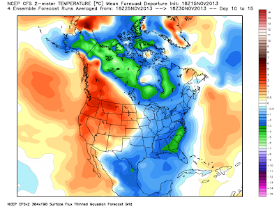
Here is the CFSv2 forecast for the remainder of the month...
For us here in PA, the remainder of the month looks like 2nd verse, same as the 1st!  But there are some changes spinning around the roulette wheel of wx! Note how AK is now forecast to get cold and look at how that cold axis is focused towards the eastern lower 48.  Also note how Greenland is turning a bit warmer as before it was cold.  This is known in the biz as a "blocky" pattern, or one that will suppress and slow air masses across the lower latitudes of the contiguous states.  If all of this comes to fruition, then the first part of December looks to be quite cold...and possibly stormy!  The CFS seems to agree...here are the temp anomalies through the 1st 10 days of December...

Now if we can get any precip to attack these "Arctic Highs" that keep coming south and east, we are looking for the potential of a White Christmas.  I'm not rushing the season, but I've had several already ask about such potential...I'd just like to remind y'all that a "White" Christmas is not a frequent occurrence here in the sub-tropics of southern PA!  Take a look...we are roughly a 1 in 4 chance...

But the probability of yet another rotund arctic high paying us a visit is rather high as the WPC shows on its latest maps!
If this map verifies, then Wednesday morning will be quite chilly...no...COLD...in these parts! All indications are that this air mass will be ever so slightly "warmer" than the last; however, with a 1032 mb monster sitting right over PA for the pre-dawn hours would mean the possibility of near record cold by sunrise...just sayin'...The Euro says cold mid-week to be sure!  But it does keep the coldest portion of the air mass over O Canada...
Here are the temps for 1 mile up come later Tuesday evening...
This air will be ushered in compliments of that robust area of higher pressure as shown above.  The predicted rainfall later Sunday night into early Monday morning will mark the cold frontal passage announcing the arrival of the colder air once again...or in the GFS' words, If you like your current wx pattern, you can keep your current wx pattern, period!  The map below depicts 4 hours of radar ending daybreak Monday morning.  
So by Tuesday afternoon, the GFS suggests the surface map to look something like this...a large area of high pressure controlling the eastern part of the USA.  Note that it is really only slightly above normal in terms of its forecasted pressure; (~1.5 SD above norms)...
But a larger and stronger area of High Pressure will be coming for the following weekend, essentially assuring another colder than normal period!  Interesting feature is obvious in the map above (tropical system), but in the map below, a more subtle look to the map is showing low pressure developing in the western Gulf and must be monitored for "Fowl" wx for Turkey Week.  
OK...enough said for now.  But I will leave y'all with this...I was once again very much entertained by the sport of high school football last evening and often look back at a game and try to understand how or why?  The East High tailback carried the ball 30 times once again for 170 yds...but in all honesty, I didn't think he had that many carries!  East High won that game in all aspects last night except in 2 very important categories; special teams (that 70 yd punt by the Dallastown punter was a "game-changer" as was the PI call on the "fake punt fade" play to the DT gunner in my opinion) and the ultimate category...THE SCORE! Nonetheless, the Panthers had a fine season, playing well into November when the majority of teams completed their season's 2 weeks back.  It's just tough to lose a game with only 16 seconds remaining...congrats to both Cats, but most definitely East High.
So who will come out of District 3 AAAA?  An Eagle or a Wildcat, or a Falcon, or a Bulldog?  That's a prediction I'll let y'all make.  I'll stick with the cold wx for the remainder of November!

Enjoy your week's end...and as always...thanks for reading!

Smitty

AA:  It's been cold so far this November...and more of the same is coming!  My favorite time of the year for high school football...but it is just a little cold at times! 


Tuesday, November 12, 2013

Under Pressure

High atmospheric pressure that is!  Once the arctic front passed through this morning with a temperature drop that would make the Plains' states proud, high pressure will be building to the south and east over the next several days.  Take a look at the NWS WFC prog for tomorrow...
For this time of the year, that is one gnarly HIGH!  High pressure, that is where the air presses harder down towards the earth, is characterized by dry and cold air, thus making the air mass heavier and more dense.  And note the 24 hour temp change!
And it's no wonder the northern plains are rebounding as their max temps weren't so much....
It will take the remainder of this work week for the air mass to moderate back towards normal temps.  In fact, for those of you with weekend plans, the high pressure should hold out long enough and fend off any overrunning SW advection that might cause clouds and light precip by Monday?  The Euro seems to think that Sunday will be relatively mild and nice for this time of year.  Here is its prog for the 850 mb temps Sunday morn...
But...another arctic front is on the way!  Here is the Euro's depiction of one mile up for next Wednesday am!  Some of the ensemble members actually have a wave of low pressure on this boundary from deep in the heart of Texas and it marches precip along the boundary towards the Mid-Atlantic.  That solution is seen on all of the global modeling, but none of the actual operational models have anything to get excited about.
HPC plays it by the vest as they have another huge arctic high taking wx control; albeit earlier than the Euro.  We have assumed control...we have assumed control...
And by next Thursday, HIGH PRESSURE will once again rule the roost...at least the GFS thinks so...
OK...I made a reference to a song I heard this past summer that I still can't get out of my head!  It is a pretty awesome 5th inning mid-game song...maybe as good as The O's "Thank God I'm a Country Boy" in their 7th inning stretch.  But seeing east TX has only whetted my appetite to visit west TX now...I hope you enjoy this as much as I...and don't feel "pressured" to agree with my tastes!
Enjoy your mid-week...and your 10°-15°F below normal Wednesday...and that doesn't include the wind!

Smitty

AA:  High pressure to control our wx through the weekend.  Then another frontal passage for yet another arctic high for later next week!  By the way, not an American League guy as you know, but I had a blast at Texas Rangers game!

Monday, November 11, 2013

One Thing For Sure

And that is that the cold is coming! The graphic below shows the precip marking the arctic front as it advances to the south and east...
...and the cold that is advecting SE towards the eastern US!  Look at these apparent MID-AFTERNOON temps! Ouch!
And the GFS' take on a deviation from norms for Wed morning!  Very cold in the deep south compared to norms...just cold for everyone else in the east!
The Euro suggests the that the cold coming will be transient, and some moderation is coming by later this weekend into early next week before the bottom drops out once again!  The top left is Tuesday and moving left to right and down...the bottom right is next Wednesday...so next Monday and Tuesday look rather mild when comparing temps to the norms.
The CFS suggests that the remainder of  November to be cold on average....
So just a very quick cursory look at temps for the rest of November.  No big snows and a phasing split flow that the Euro showed us last week in 4 consecutive runs...oh well...the GFS got 'em that time!  But "King Euro" will take the GFS to school a few times more prior to this calendar year ending.

OK...enjoy your Monday Night Football...and doesn't that last regular season game look somewhat intriguing now between the Cowboys and The E-A-G-L-E-S...EAGLES!

Smitty

AA:  Pretty darn cold for time of year rest of the week.  Wednesday the coldest.  Then moderating (mildest next Monday and Tuesday) until another arctic blast middle to end of next week...