Saturday, September 8, 2012

Hope and Change

Over the last several days, I've had many people comment to me as to how uncomfortable the weather has been lately in terms of both the late season heat and especially the oppressive humidity that has been in place since the landfall of Isaac.  Well, I have some good news y'all; I have some hope and change!  The hope lies in a cold front that will translate across the state today while the change will be evident in the blissfully obvious reduction of humidity by Sunday and through early next week.  In addition, the air that will invade PA is coming essentially straight from the land of Nunavut where dew points in the 40s would be considered humid!  The map below shows the cold front at 2 pm Saturday afternoon.  The hope...
Unfortunately with such a strong and vigorous frontal passage thanks primarily to the upper air dynamics, severe weather will be common later today as the front passes our region during the maximum heating of the day.  The Storm Prediction Center out of OK has issued a moderate risk of severe wx with a 45% likelihood of wind damage in the pink shaded area.  Why pink???
Tornadoes are also not out of the question as the upper air vorticity is such that rotating thunderstorms and violent updrafts will be observed along and near this surface cold front.  Here is the 500 mb prog for later today as well...note the vort maxes along this digging and strengthening trough!
But this front will usher out the old humid air and deliver the goods from O Canada...Note the 70+ dew points for ~noon Saturday...

...and the MUCH DRIER air 42 hours later...ahhhhh...change we can all appreciate!
Once this cold front clears the east coast, a sprawling area of high pressure will move SE and control our wx over the next several days.  I believe that we will experience some of the upcoming work week mornings with temps in the 40s...especially Tuesday morn.

There will be a few short waves in the upper air flow that may interrupt this stellar week of weather which we will experience the next several days after today's transitional severe wx day.  So there you have it; Hope in the form of a cold front and Change in the air masses!  Now that is my kind of Hope and Change!

High Hopes is a song from one of my favorite groups...Pink Floyd (Not Harry the K singing as he so eloquently crooned during his life here on this earth).  Here are the lyrics and the accompanying video...enjoy your weekend!

Beyond the horizon of the place we lived when we were young
In a world of magnets and miracles
Our thoughts strayed constantly and without boundary
The ringing of the division bell had begun

Along the Long Road and on down the Causeway
Do they still meet there by the Cut

There was a ragged band that followed our footsteps
Running before time took our dreams away
Leaving the myriad small creatures trying to tie us to the ground
To a life consumed by slow decay

The grass was greener
The light was brighter
With friends surrounded
The nights of wonder

Looking beyond the embers of bridges glowing behind us
To a glimpse of how green it was on the other side
Steps taken forwards but sleepwalking back again
Dragged by force of some inner tide

At a higher altitude with flag unfurled
We reached the dizzy heights of that dreamed of world

Encumbered forever by desire and ambition
There's a hunger still unsatisfied
Our weary eyes still stray to the horizon
Though down this road we've been so many times

The grass was greener
The light was brighter
The taste was sweeter
The nights of wonder
With friends surrounded
The dawn mist growing
The water flowing
The endless river


Happy Saturday!

Smitty

AA: A strong cold front will produce nasty storms with strong winds, heavy rains and possibly some hail for Saturday afternoon.  Then, a week of nice fall wx!

Wednesday, September 5, 2012

Soggy Saturday?

Longwave troughs often bring unsettled conditions to regions on the earth's surface that are under the weakness and on the "business" or leeward side of the trough. A longwave trough is looking more and more likely to dig SE and amplify to some extent this weekend over the northeastern USA.   As a result, some showers and possibly even some heavier rain are likely this weekend over the eastern 1/3 of the USA as some deep moisture could be picked up and advected NE to rain on our parade.  Let me graphically show y'all this....By the way, the modeling is in fairly good agreement with this scenario which tends to create a little higher than normal confidence in this fearless forecast!  First, let me show you the water vapor image and the deep tropical moisture that could enhance any rains here in the Mid-Atlantic this weekend if it gets pulled NE by this digging trough.  Note the bright white in the northern Gulf of Mexico...Also, just off the eastern edge of the image is Hurricane Leslie.

Here is the longwave pattern as per the GFS for this weekend...That is a fairly deep and vigorous trough for this time of year if this model verifies!  Notice how the deep gulf moisture would be able to advect NE directly towards us here in PA!  There is also a rather strong vort max over southern Ohio that could help enhance the surface low pressure and increase the amount of precip...time will only tell.
The next few maps are all for Saturday late afternoon from various models.  Just compare for yourselves the position of the low pressure systems and the potential problems for our weekend wx.  First, the GFS...it has taken its low into northern NY with rainfall from the Carolinas to ME...
Here's the Euro...it has a deep low cutting up through the lakes and will undoubtedly spin up a secondary just to the SE of the primary center and rain out over PA and points north and east...
Here is the O Canadian...similar to the GFS, but even wetter...slightly faster and more progressive...not insurance!
I'll even humor y'all with the Navy model...clearly an elongated frontal passage is indicated as opposed to a wrapped up storm system over NY or thereabouts...
Finally, the regional and higher resolution gridded NAM...from this far out, the NAM is usually good for a few yucks and that is about it!  Did you guys notice that all though tend to have Leslie in the same general area!
Finally, here is the HPC's take on the precip that might fall over the USA for the period Friday evening to Saturday evening...looks wet up and down the eastern 1/3 of the nation.  Personally, I believe there will be a greater amount of rainfall over central PA as well...again time will tell!
So there you have it...a quick look at this weekend.  And while we all talk wx, football, baseball, politics, or whatever we might discuss, lets also think about the humanity that was adversely affected by the 7.6 that struck in Costa Rica earlier today.  I can't even imagine...

 
In closing, go Os...

...and enjoy your NFL opener this evening.  How 'bout them Giants (just for you Mick & KM)?  Trust me, that's difficult coming from an Eagles fan!
Enjoy the end of your week......

Smitty

AA:  Looks like rainfall could threaten our weekend, especially Saturday!

Tuesday, September 4, 2012

Convective Rains

Just a very brief post to show how the rainfall will be over the next 48 hrs or so in these parts...very hit and very miss.  The map below is a map from York County and its immediate surrounding counties showing the 24 rainfall totals ending either 6 or 7 am Tuesday morning.  Note how a 10 mile distance can result in a 2+" difference in the rain gauge! 
And that is why the rainfall totals over the next 3 days will not be very uniform across our region.  Get under a few of these heavier rainers...and look out below!  Here is the 3 day total rainfall from HPC...personally, I believe that we are a bit underdone in south central PA.  Also note the "hot spot" along the Gulf coast.  That is the potential trouble maker for this weekend...a nor'easter of sorts.  It is actually part of the leftover upper air energy from Isaac...if you can believe that!  That low pressure will be progged to move slowly north and east affecting us later in the weekend.
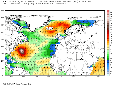
In addition, Hurricane Leslie will need to be watched closely.  At the very least, the ocean will be rockin' all up and down the eastern seaboard this week into early next week!
Check out the wave-watch model for the ocean this weekend!  8-12 footers pounding the MD, DE and NJ beaches this weekend!  It should be quite a show!

OK...gotta run for now.  Enjoy your Tuesday!

Smitty

AA:  Damp week through Thursday.  Weekend, especially Sunday looks questionable as well.  Wary eye on Leslie in the Atlantic.