Smitty's attempt to educate and to a much lesser extent, entertain, about all facets of life; but primarily the meteorological and the climatological aspects of the earth sciences.
Well, February 2 is here and this marks celebrations all across Dutch settled regions of Marmota monax, commonly referred to as the groundhog. Whether it's the prognostication from the gold standard Punxsutawney Phil or the lesser knowns of Octoraro Orphie and the very little know Etters Eddie, on this cross-quarter day astronomically, people will want to know if these mammals have seen their shadows. And though long range weather forecasting can be a challenge, Phil doesn't do a bad job! He certainly does have a bias towards more winter...and rightly so as we still have February and early March to get through. Heck, last year we here in PA experienced winter type weather right into April! Here is a graphic showing Phil's predictions since 1887...
Phil did see his shadow last year and was correct with his call. Try to recall the FOUR nor'easters of last March! The other notable "bingo-front row" forecasts of recent times were 2014 and 2010 where February in these parts were quite snowy! Below is a time-lapse of last year's barrage of storms to hit the eastern US...it's worth the 50 seconds...
So with the recent snow and cold entrenched in our memories, will Phil call for more winter? Or will he check out the numerical guidance that suggests winter is over, at least for this upcoming week? If he looks at the Euro's guidance for the 1st week of February, this is what he will see...
But that 2nd week of February is indicating a classic battleground setting up in the eastern US which could create another cold and stormy pattern in these parts. Look at the warmth across the SE US compared to the strengthening cold across the rest of the continent. Usually, the cold wins these battles at this time of year.
And simply for kicks and giggles, here is the Euro's guidance for both temperatures and snowfall into the middle of March. If Phil sees this, he'll quickly see his shadow and regroup in his burrow for another 6 weeks! First the temps...the entire US below norms with the lone exception of Florida! That's suggesting winter is taking a brief respite this week before reloading...
...and this graphic below suggests a stormy time of it here in the eastern US. February is often a snowy time in these parts...and this numerical model guidance is indicating snow all the way to the Gulf coast in TX and LA! Heck, if that is even remotely close to being modeled accurately, Phil will have a difficult task clearing snow from his home in Punxsutawney!
As for today's astronomical celebration, the sun has progressed to about its 1/2 way point from the noon sun angle being over the Tropic of Capricorn to the noon sun angle being over the equator! Our 9 hours of daylight have lengthened into about 10.5 hours and soon on the Vernal Equinox, our noon time sun angle will be a much warmer 50º as opposed to a very ineffective and dark 26º. So that is indeed something to celebrate!
Enjoy this Groundhog Day blues tune from Johnny Lang and Double Trouble!
Happy Groundhogs' Day!
Smitty
AA: After winter loosens its grip this upcoming week, it appears that we are back to a cold and stormy pattern to close out winter...at least that what the numerical models are indicating.
FYI...around noon today...a strong squall line will be advancing through our region and is likely to create a quick accumulation of snow in white-out conditions! We living in the Harrisburg region are not to accustomed to such winter events; just be aware. This is the arrival of the truest of arctic air! Temps will drop this afternoon and winds will be gusty creating windchills 10-15 below 0. Just wanted y'all to know...if you didn't already!
As I was departing my place of employment today, a co-worker (and loyal reader I might add...) so eloquently asked "well Smitty, are we ever gonna get a real storm this winter?" Frankly, I forget my quick and not so thoughtful response...sorry...but it got me thinking that many of us think, living here in the sub-tropics of North America, that we should get major snow storms each and every year. As a getting there "old-head", I've had my share! You youngins...you had more than you should! The true old timers are where the snowstorms regress to the mean...please let me explain.
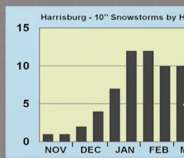
The graphics that I'm using for the most part come from the heavy lifting of Dr Jon Nese of PSU; he recently did a segment on my favorite TV show "Weather World" about 10"+ snowfalls in PA! The statistical breakdown was 2nd to none. I will paraphrase his emphasis...
First, the number of 10"+ storms at his chosen 5 stations in PA since the late 1896...
...and then divided down to each decade period...(10 years y'all, I guess I'm still in the classroom!)
So basically every other year we should get a good one in these parts. My loyal reader, likely more often since my loyal reader is skewed NW of KMDT towards KUNV but the names will be confidential so as to not admit as being identified as a "loyal reader"...!
As for KMDT...which I believe has a low bias snow measurement as does KDCA in Washington DC, we still have the first part of February before the frequency of such snow bombs begin to decline, albeit minimally...
The graphic below I found interesting as this was KMDT's snowiest winter on record...one of the only FIVE times...yes...FIVE times when these FIVE sites had 10"+ storms all from the same storm!
Of course the grand-daddy of east coast nor'easters...The superstorm of 1993...
I wasn't alive for the 1961 blast, but I'm sure most of y'all recall 1993! It occurred on a Saturday into Sunday(thundersnow, too!) and we got back to school Thursday...it was a doooooozy!
Just an offshoot...KMDT's biggest snow is not even a big deal in the 4 other locations so much...take a look! And y'all enjoyed that storm to be sure...(I did beat IV on the O/U for once!)
For those of you keeping records...here is the NorthEast Impact Snowstorm Scale broken down by years...please feel my pain; I lived the weather from the 70s through today; had a few fun ones lately and back in the Clinton years, but we all live here in the Sub-Tropics as I am so insistent!
OK...I've rattled long enough; some of 8th period is probably glad that they didn't have to hear my discourse, but for those of you who read and appreciate, a genuine "Thank You"...and one to Dr Jon Nese for the graphics and heavy statistical lifting...and one to my loyal reader who shall remain anonymous living halfway up 322 towards PSU! Maybe not so much anymore...
OK, I'm out; big flakes with the wave spinning up the front currently over my place! Looks like January outside to be sure; will feel like it the rest of this week!
Enjoy my song choice...and if any of you who listen to the songs have ideas associated with the weather, please let me know! I'd really like that...
I do like Mumford and Sons...
Smitty
AA: A nice snow event this afternoon into the evening, then the arctic emperor invades! Check out these wind chills Thursday am... Brrrrrrrr! Bundle up yourself and those darlings of yours!
It's about 16 days until pitchers and catchers report to their spring training facilities. OK...so what does that have to do with the weather? This is the point in the calendar where we usually are enduring winter's worst offerings whether it is in terms of snow or cold or both. Well, both are most certainly on the table, but record cold is lurking for these parts next week. Let's go to the maps...
In the graphic below, note the colors over Hudson Bay, O Canada...that is the coldest air in the northern hemisphere and it is poised to make a run at the USA...
Look at where it is 96 hours later...brrr! Also note the little "kink" in eastern Tennessee...
Well that little "kink" has the potential to spin up a nice little potent wave on the advancing arctic front that will make living a tad difficult in old Rocky Top along with the good folks around here in KMDT! Now it's a good thing that we don't live up at 850 mb...
...because -20°F is quite cold to be sure! And as y'all who read these regularly know that I like to look up at that level of the atmosphere to see where the air masses want to move without the effects of the earth's friction from the surface. That air mass over Ontario, the UP, and northern Michigan is the coldest air in the northern hemisphere at that point in time! Safe to say, the hearty people of Mackinac Island will be thinking of glorious summer temps in the 60s as opposed to what they are about to embrace! One of the more "interesting" canoe trips I've had was when we were told to "keep it in the inside lane and not travel any faster than 25 mph" as we traversed the Mackinaw bridge toting a Old Town atop a small pick 'em up! The winds that July evening were such that the trip to the UP is still well ingrained in my gray matter! Very interesting to be sure...looks like they'll be breaking out the shorts come Super Bowl Sunday on Mackinac Island!
OK Smitty...that's nice for the populous of northern Michigan, but what about us? Cold and potentially snowy is the call. Cold is easy; the snowy is a challenge for those of you wanting! When the upper air gets crazy in these parts, I've learned over the years to look at analogs...that being what has happened in the past may just play out again in the sensible weather here at the surface where we all live, and work, and play! This is the most recent correlated analogs from the GFS ensembles for next weekend...and there are 4 heavy hitters in this graphic.
Most of you remember the PD II storm of 2003 and many of you remember the 1979 PD storm too. Both were memorable to be sure. The 1994 analog is also rather intriguing...so for those of you wanting snow with your cold, there is most certainly some hope for y'all. Here is the Euro's depiction of snowfall come Wednesday morning with the high ratios being shown; it will be powdery on Tuesday night with the arctic front if it does indeed come to fruition...
And if we do have at least some snow on the ground, a below 0 morning will await us come later this week...just think you could really be enjoying some Chicago blues come Thursday morning so it's not that bad in these sub-tropical parts!
OK...I've depressed y'all plenty with winter worst about to pounce. So enjoy this uplifting ditty as did I looking for the version I wanted to share...Enjoy!
Man that looks like a ton of fun!
Smitty
AA: An arctic front will push through later Tuesday bring very cold air, gusty winds, and likely some powder to accompany Nanook from the North! Just wondering...you get your corn from a jar?
My song choice is easy tonight...We're Living on the Edge! As this storm has evolved numerically this past week, we here in south central PA have gone from 2'+ of wind swept powder to 1" slop with mostly a raw rain...the truth likely lies somewhere in between.
As like last evening, very few maps. But one I'd like to dive into...The Race is On...uh, oh, another song reference! Sorry, I digress...
If the arctic high ridges faster and further east than the surface low and upper air support; game on for a heavy snowfall. If, however, the southern low begins to phase with the cold baroclinicity diving from the north country and tries to attack & warm the digging arctic air mass fruitlessly, ice will be the call. Mathematically, I'm sure these software programmers are all over the thermodynamics; there is no question in my mind! Stochastically, a push here and a pull there is all that is needed for a boom/bust forecast! We are literally in the battle zone for precip types! The front thump will be the snow accumulation; sleet and freezing rain will rule the remainder of the fast moving disturbance.
And as mentioned before, clear the slop; otherwise plan on being a brick layer/mover/melter...If we get 4" of snow/ice, I truly believe we will see sub zero temps both Monday and Tuesday am...
Fun stuff! Go Rams and Chiefs!
I'm out...by the way...went with my 2nd song reference...
Smitty
AA: Gut call Timmy; you'll have 2-4" more accumulation of "stuff" than Kay and I! My field mower wants to do it when the ground is frozen this year...imagine that!
Guidance. That's what numerical modeling is...just that...GUIDANCE. If all weather forecasting was simply interpreting the models, it's not all that much fun. But to try to interpret trends, understand certain biases of said modeling, and ultimately understand the climatology of where one is located (I have lived here (KMDT) essentially all my life with the lone exception of PSU), now that is the challenge that I most certainly enjoy! Frankly, as most of you know, I view these numerical models of the atmosphere most everyday; not every run, but most everyday. With that said, this upcoming storm for the weekend has been incredibly consistent with the modeling in regards to the following: our area will receive about 1.5-2.0" of precipitation! All global and now recently regional models have been consistent that this will be a dandy for winter precip! But how does it fall Smitty? To the ground, of course, in various forms over the next 72 hours will be my reply...please let me explain...
A week ago, the Euro model hammered us with a 2' blast of winter's worst; all snow and I shared that pic with my iMessage group...because that's what I do. That got some eyes raised I do believe...including mine as the previous runs have kept this mundane winter to date pushing through MLK Day. But not so fast! Oh no; pattern change and quick it was. Within a day, all the global models had a similar fate; heavy snowfall for PA and points north and east...
Then the model game began; oh no...north; oh no...south; oh no...warm; oh no...Eagles lost (sorry).
So what's the point that I've read this far? After this evening's "skiff" as I like to call these overrunning events, the Saturday night into Sunday storm WILL be an ordeal! Whenever a sub 1000 mb (with juice) low pushes south of PA with a 1030-1040 mb high "bananing" over Quebec, be aware! I'm still looking at a Saturday afternoon-evening thump of snow, followed by a prolonged period of pingers (sleet), then sleet and freezing rain to glaze everything that will make Mr. Heat Miser quite happy! And then for some kicks and giggles, another 1-2" of wind blown powder being accompanied by the arctic emperor of the north. For what it is worth, I do not believe the mercury (Hg) at KMDT will reach 32°F until Wednesday once the precip begins in earnest (or in Harrisburg). And come Sunday, a biting cold NNW wind will advect flash freeze conditions into our region very quickly. So whatever is on walks and drives, get it pushed away so as to not have a glacier reminding you of the prior weekend a week hence!
One map...please understand this includes sleet, freezing rain (problem), and of course a heavy front thump of snow.
As always thanks for reading...and many tell me they like the music better than my Wx talk...so I hope y'all enjoy this; these chicks know how to rock!...Seasons change with their scenery!
Be safe,
Smitty
AA: Weekend storm WILL be the most impactful of this winter I do believe...comparable to VD 2007 storm thanks to the flash freeze component Sunday pm. Go Chiefs and Rams!
Just a very quick update as to my thoughts as y'all will hear many different ideas from many different sources...My thoughts are as follows:
1- Uncertainty remains as to frozen precip types and amounts
2- Plain rain will be difficult here with a big high to the north and arctic air pressing strongly
3- Confidence is gaining as to a very impactful storm Saturday evening into Monday
4-Very high confidence to bundle up and clear things quickly Sunday before a flash freeze occurs!
The maps...Euro ensembles as to the low pressure's location...uncertainty.
...and where it moves to 6 hours later...note how the surface low stays south of PA and keeps PA in the cold air, at the very least at the surface.
As for temps, the warmest progged by the Euro is Sunday morning where a hodgepodge of precip types will be falling in these parts...but the temps will be upper 20s to near 30°F...you do the math.
And by nightfall...well...brrrr...and this doesn't include the gusty NNW winds! A good time to watch football if you have everything cleared!
I am humbled by the many comments from y'all who read these and like to hear my ideas on things. The one adage I have seen fairly consistent over the years is "Predict the high, predict the snow"...and with a 1035 mb high in Quebec and and 1042+ arctic high plunging into the Great Lakes, cold air is abundant at all levels...so time will tell. I do think this will be a rather impactful winter event...and that is my call.
Enjoy this old jazz tune as did I looking for an appropriate ditty...
Smitty
AA: Still a 2" precursor snow Thursday night into Friday morn to our impactful snow, sleet, frz rain mess to concrete by Sunday night!