Monday, June 4, 2012

Partly Iffy for Venusian Transit

The amount of cloudiness may actually be a benefit to observe and to photograph the transit of our sister planet on Tuesday evening.  Beginning around 6 pm Harrisburg time, Venus will begin to enter the space in the sky occupied by the sun!  From 6 pm until sunset, Venus will appear in front of the solar disk.  This is a transit.  Mercury transits about 13 times per century; Venus in a strangle cycle of 8 yrs...then over 120 yrs.  So relatively safe to say that if you miss tomorrow's transit, you'll not see this exquisite event again in your earthly time.  So get out and enjoy....if we are not totally obscured by clouds!
The map above depicts the worldwide regions where one can observe this celestial feast for the eyes!  The picture below shows where about (and the time) the atmosphere shrouded orb will be transiting ol' Sol.  The 2004 transit also occurred in June and at sunrise that gloriously "foggy" morning, the low clouds and fog provided ample screening from the intense solar radiation that observing the event was actually very easy.  In addition, the fact that if you do have a good horizon with minimal obstructions, earth's atmosphere itself will provide a measure of filtering that will enable us east coasters to view with a lessen intensity of solar radiation. 
As for the surface depiction for clouds and precip tomorrow evening as per the NAM, here it is...There is a lonely shower in the Harrisburg area, but trust me, to try to forecast where exactly low clouds (solid grey shading), or scattered clouds (dashed lines) or even radar echoes are located; one might have a better shot at predicting the College World Series winner this year (Stony Brook Univ)...
This week will be cooler than normal...here is a map of the 7 day mean ending Sunday...
In closing, here is a nice little recap of the Venus Transit that will occur Tuesday evening beginning at 6 pm...
And go Stony Brook University in the college World Series!
Smitty

AA:  Venus transit Tuesday evening...get out and observe this celestial majesty!

Friday, June 1, 2012

Severe Potential Update

Just a very quick update as the SPC has updated their graphics as well.  There is now a moderate risk area outlined that is just to the south and west of the immediate Harrisburg area.  Take a looksie...
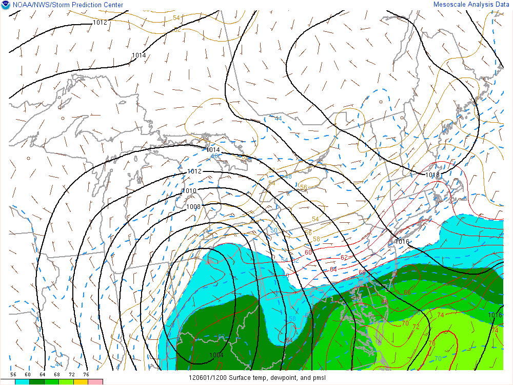
Very warm temps have made their way up to central MD and the DC region.  The higher dew point temps have been held at bay due to the persistent onshore low level easterly wind from the cooler Atlantic Ocean.  That is quite a surface low pressure over northern Ohio!  Note the red isotherms pushing northward just to the west of the Chesapeake Bay!  Our dew points remain in the upper 50s.
As a result of the warmer and much more humid air, the CAPE values are also increasing.  Here's the latest map. 1,500 J/Kg is the usual threshold for strong thunderstorm development.  Values much higher indicate a near certainty!  2,500 J/Kg would be considered extreme...as in south central VA at this time.
And here is how the CAPE (Convective Available Potential Energy) has changed since 10 am this morning...
We are still looking for heavy rain to break out later this afternoon into the evening hours.  Here is the rainfall total as per the NA from the wx system that will pass through Friday evening...Again, very difficult to model exact locations as to where the banding thunderstorms materialize...
Enjoy your week's end!

Smitty

AA:  Still monitoring the severe wx threat later today...

A Very Tricky Severe Wx Forecast

To be sure, heavy rain looks like a near certainty during the next 18-24 hours; however, the severe wx parameters of hail and tornadic storms is a much tougher call...as is so often the case.  But especially so today since the low levels are quite stable in our immediate Harrisburg area as the dew points are in the mid 50s and the temps are in the low 60s at present (9:00 am).  This keeps our atmosphere stable and inhibits convection or the development of the potentially severe weather.  As does our current ENE wind.  The longer this coolness stays, the more difficult to create severe instability!    Here is a current map of surface dew points.  Very humid air (energy) is located as close as southern MD. 

And as the humidity gets drawn northward into the surface low over NE Ohio, this should allow for the warmer and more humid air will quickly move into southern PA.  Take a look at how the CAPE has increased over the last 3 hours.  CAPE is simply a measure the potential for convection...
Note how the CAPE and the increased instability is creeping northward into southern PA.  There will also be a very strong jet in the low-mid levels of the atmosphere modeled for later today.  This will increase the likelihood for enhanced upward motion and ultimately severe wx!  The gold arrow points to our approximate location.  This is modeled for ~ 8 pm this evening.  Although the modelers are outstanding in their trade, it is very difficult to pinpoint the exact locations of these potent pockets of fast winds!
Wind shear is also a concern.  Shear has many meanings, but the change of direction with height is critical in determining whether severe weather will occur.  Here is a plot showing the wind shear over KMDT later this evening...this shows the winds from the surface to the 35,000' level.  There is quite a bit of wind shear in the first 10,000' of the atmosphere.  This is conducive for creating storms that rotate or possibly produce tornadoes.

The Severe Storms Center still has us in the "Slight" category for overall severe wx but here is the probability map for tornadoes to occur within a point of 25 miles within the shaded area...
I believe straight line wind will be our largest concern with the approaching front later this evening.  I also believe that 1.50" of rainfall is a good bet!  As does HPC with their QPF through tomorrow morning at 8 am...Also note more tropical troubles in south FL!

One thing for sure is that the next week to 10 days will be cooler than it has been recently.  Here is the 7 day running mean ending next Sunday...quite cool for the Mid-Atlantic and NE quarter of the US.

With all of that, get through the storms of Friday afternoon and overnight, enjoy your weekend and the upcoming cool 1st week of summer!

Smitty

AA:  Potential for some nasty storms Friday evening into Saturday early morning...then a cooler than normal week the 1st week of June!

Thursday, May 31, 2012

Severe Wx Potential For Friday PM

This is simply a quick "heads-up" as to the very real potential of severe weather affecting us in the Harrisburg area for Friday afternoon and into very early Saturday morning.  A vigorous surface storm with its attendant fronts will materialize thanks to strong upper air support especially at the 500 mb level as shown below...
The closed low in the mid levels will push a strong jet over central PA late Friday afternoon further enhancing the upward motion that is necessary for severe wx events.  In addition, a triple point (occluded, warm, cold fronts meet) will saunter across PA late Friday afternoon and should be the focus of the greatest surface forcing that will produce heavy precip...Take a looksie.....
The precip that affects us here in PA will come in 2 stages I do believe...the first will be overrunning from the warm front advection and the 2nd bout will be convective as the cold front and triple point low passes over the state.  Take a look at the precip potential for Friday into Saturday...I'd say 1-2" is a very real likelihood by Saturday noon for KMDT!

And the Storms Prediction Center seems fairly confident about the possibility of severe wx.  That is a rather large area for "slight" from 2 days out for the SPC.
And note that we are in the 30% region for severe wx to occur within 25 miles of any point within the shaded region.  The majority of the "red" area is associated with the passage of the cold front Friday evening into early Saturday.
So just a quick heads up as to the severe wx potential....and have a good end of your work week!

Smitty

AA:  Potential for heavy rain and severe weather for Friday pm into early Saturday.

Wednesday, May 30, 2012

Much Cooler Weekend On Tap

The recent heat will be knocked back substantially over the next couple of days thanks to upper level troughs that continue to work their way in from O Canada.  Last evening's storms were a warning shot that the cooler air is now most decidedly on the move and advecting SE towards PA.  Here is the daily mean temp anomaly for Saturday.  For us in eastern PA, we are looking at ~8ºF below norm day which would keep our high temps right about 70ºF!
Part of that will be the residual cloud cover which will remain from the overnight rains of Friday evening into early Saturday...
But by Sunday, we are looking at a very nice late spring day with max temps in the upper 70s with low humidity...
The only other thing I've got to say is I sure hope I'm sitting at the York Revolution Stadium (SBS) Thursday evening with the CD Ram baseball team vying for their first ever District 3 baseball title...
Have a good mid-week....

Smitty

AA:  Much cooler weekend.  Still a shot of a stray shower today.  Beautiful tomorrow!  Clouding up for some late pm Friday rain...clearing and much cooler this weekend.

Saturday, May 26, 2012

Refreshing Reversal

Just a very quick update as to what next week might have in store for us.  I believe we are now looking at a major temperature and air mass reversal by next weekend.  Here is the "high tide" of heat and humidity for this weekend according to the GFS ensembles...

But by next Saturday, the upper air pattern completely reverses with a deep trough over the Ohio Valley and a ridge out west.  Many of the members create a cut-off upper low that will once again create a lengthy time of unsettled weather here in PA as it migrates eastward from the Ohio Valley during the course of next weekend.
Here is the operational run of the GFS for next Saturday.  Note the upper low centered over WV and western PA...with a negatively tilted trough!  If only this were January!
Here is the surface map for the same time...with the red line showing the temps at one mile up being ~10ºC...that would keep temps in the low 70s for us at the surface...

We might actually be looking at a somewhat dreary time of it next Friday-Sunday or somewhere in that time period.  Here is the GFS' read on total precip during the 60 hour period...you can clearly see the results of the line of showers and thunderstorms that will accompany the frontal passage that runs from Michigan to Mizzou...another major maxima of precip is centered just off to our east...

A large area from Texas to Toledo will be experiencing much below normal temps for next weekend...and we here in PA, somewhat below the norm...a clear reversal from this weekend!

So enjoy this warm and humid summery weekend that we celebrate not only as the traditional 1st weekend of summer, but much more importantly, a Decoration Day, a day of remembrance for those who have died in our nation's service and protecting our freedoms which are far too often taken for granted!
Smitty

AA:  This weekend very warm and humid; summer-like.  Next weekend...not so much!

Friday, May 25, 2012

Warm and Humid For Memorial Day Weekend

This is about as summery as we can get for the end of May in these parts.  Oh sure, it can get warmer, but the nighttime mins will be very mild due to the high humidity in the air.  Here is both the NAM and the GFS prog for the highest dew points over the weekend...which looks to be Saturday.  Yellow puts us in the dew point range near 70ºF.
Here is the max temps for Sunday...mid to upper 80s look to be in store.  I believe Monday will surpass 90ºF!  Clearly the hottest temps will be out over the Mississippi Valley.  You can also see the "cooler" temps along the Carolinas as a tropical system gets its act together for a possible strange landfall coming in from the northeast!
And the last 2 graphics show the max temps for Monday, Memorial Day.  Note the cooler temps over northern PA as some thunderstorms are developed over the north country and keep temps down!
Here is that rainfall that develops....although I'm not totally sold on that solution....I believe most of Memorial Day will be dry from rainfall!
So that is a very brief synopsis of this upcoming week's end!  Enjoy...and please remember our reasons for celebrating Memorial Day!
Smitty

AA:  Warm and very humid this Memorial Day weekend!