As most of you know by now, I love the winter season and snowstorms in particular. With that said, I'm still hesitant to call for what the major modeling from around the globe have trended towards for over a week now....all except the lovely American GFS. After this morning's run of the Euro, I felt a little more confident that a real potential exists for an early season, possibly once in a lifetime historic snowfall for our region. After seeing the 12Z Euro and the finally the GFS, I am now quite confident that snow will fall in our area and accumulate several inches very quickly during the daylight hours of Saturday. Most of the accumulation will be on non-paved surfaces, but therein lies the problem. With gusty winds, a heavy wet snow accumulating on trees and power lines WILL DO SEVERE damage if this snowfall verifies! Here's the Euro for Saturday evening...
And here is the GFS for the same time...
They look fairly close in their agreement! Here is a quick look at the plumes for KMDT. Note that most of the ensembles are all snow and the average amount of precip is over 0.6 inch! Even at 5:1 ratios, we're looking at 3 inches of heavy wet snow on grass and trees! Couple that with wind and we've got some issues. Look for greater accumulations in the higher terrain of our region!.
Here is the NAM's snowfall ending Sunday morning. That is quite a snowfall. I believe the heaviest belt will be west of where the NAM algorithm has it located. This is unreal....I wish it were January, I wish it were January....
As for Friday night lights, look for mostly clear skies with some high cirrus moving in as a precursor for Saturday's event. Winds will be gusty during the day, but once the sun sets, they should abate and temps at kickoff should be in the mid 40s; nice fall football wx! Take a look at the progs for temps and winds for Friday pm....
And now winds...
So there you have it...October's version of a nor'easter coming to the Mid-Atlantic. For some a trick; others a real bona fide treat!
Have a great Friday!
Smitty
AA: After a nice, but coldish Friday, watching a nor'easter crank for Saturday with limb busting snows on foliated trees!
Smitty's attempt to educate and to a much lesser extent, entertain, about all facets of life; but primarily the meteorological and the climatological aspects of the earth sciences.
Thursday, October 27, 2011
The Euro is a Hit
A hit along the eastern seaboard with coastal rains and inland snows that would actually accumulate of grassy surfaces and trees and powerlines. The water content would be quite high and it could actually be quite an ordeal somewhere between northern MD and ME. Here is the latest run from the Euro...it is quite a storm with ample cold air entrained to do some serious wintery precipitating!
As for the middle of next week, the Euro takes the remnants of Rina too far east to deliver any heavy rain to our region...and that's not a bad thing. I'm just not convinced yet that will be solution, but it looks like Rina's remnants will be a swing and a miss!
Have a good Thursday!
Smitty
AA: None needed this am.
As for the middle of next week, the Euro takes the remnants of Rina too far east to deliver any heavy rain to our region...and that's not a bad thing. I'm just not convinced yet that will be solution, but it looks like Rina's remnants will be a swing and a miss!
Have a good Thursday!
Smitty
AA: None needed this am.
Wednesday, October 26, 2011
The Cold was the Easy Part
This late week's forecast was challenging from the get-go. But I was fairly certain the cold was coming. And as shown below from the NWS, a freeze watch has been issued for our immediate area Thursday night into Friday morning. This watch extends into northern MD as well. See below...
With the passing of a weak low pressure system just south of PA on Thursday, cold air will advect south once the low passes our longitude and send cold air bleeding south into the Mid-Atlantic. Most of the precip will be past, so snow will not really be an issue for the KMDT area. However, in the northern and northeast part of the state, snow could accumulate a few inches, especially at elevation! Here is the latest NAM's take on accumulated for Thursday's snowfall.
But the real interesting situation develops late Friday into Saturday. The modeling is now coming into some sort of consensus, that being a storm, not as strong as originally modeled, and slightly off the coast a bit further. BUT CLOSE ENOUGH TO AFFECT OUR WX SATURDAY. The Japanese model is the most bullish for nasty snowfall for our region during Saturday into Sunday. I believe this scenario is a bit overblown! This would be a major snowstorm from downeast ME to around Philly!
The Euro is a bit flatter and further away from the coast, but still having an impact along the I-95 corridor...and possibly back to us here in Harrisburg!
Then the Japanese model spins up a doozy from the remnants of Rina which is currently spinning her way around the Gulf! Look at this moisture laden system. This solution does have some potential for the middle of next week! Snow is not a concern with this as the thicknesses are much higher (warmer), but heavy rain would be a concern!
So as we march onto November, the atmosphere begins its countdown to winter and the cold weather season. Had this pattern set up like this in December and January, my oh my, this would be rather intriguing! But it is only October, and winter type precip is transient when it occurs. But I do believe people will get a real dose of cold when Friday morning arrives and feel just how cold it became so quickly. So I hope you enjoyed this last mild day for quite some time as the afternoon temps achieved 66F; it felt quite balmy at Landis Field. But the cold air is ready to pounce and be in our area in spades beginning late Thursday and through the weekend. Sunday will prove to be a nice day with a huge dome of high pressure over PA as shown below, but it will still have a bit of a bite to the air.
Speaking of bite, Happy Halloween y'all. After all, Halloween has its origins not in ghosts or goblins, but as a cross quarter day, that being a day halfway between the Autumnal Equinox and the Winter Solstice! All Saints Day falls close to the 4th Quarter Day of the Earth's Revolution cycle. Halloween, a pagan celebration of All Hallow's Eve was recognized close to the 4th Quarter day of the annual solar cycle. It still seems to be the most celebrated of the quarter days, although I'm partial of the celebration commemorating my buddy from Punxsutawney, PA, that being Groundhog's Day!
Enjoy your end of the week!
Smitty
AA: Damp and raw Thursday with rain ending as the cold air arrives, then a cold Friday with the potential for some wintry type precip on Saturday. Middle of next week, we could have a real soaker from the tropical disturbance down in the Gulf tonight.
The Euro is a bit flatter and further away from the coast, but still having an impact along the I-95 corridor...and possibly back to us here in Harrisburg!
Then the Japanese model spins up a doozy from the remnants of Rina which is currently spinning her way around the Gulf! Look at this moisture laden system. This solution does have some potential for the middle of next week! Snow is not a concern with this as the thicknesses are much higher (warmer), but heavy rain would be a concern!
So as we march onto November, the atmosphere begins its countdown to winter and the cold weather season. Had this pattern set up like this in December and January, my oh my, this would be rather intriguing! But it is only October, and winter type precip is transient when it occurs. But I do believe people will get a real dose of cold when Friday morning arrives and feel just how cold it became so quickly. So I hope you enjoyed this last mild day for quite some time as the afternoon temps achieved 66F; it felt quite balmy at Landis Field. But the cold air is ready to pounce and be in our area in spades beginning late Thursday and through the weekend. Sunday will prove to be a nice day with a huge dome of high pressure over PA as shown below, but it will still have a bit of a bite to the air.
Speaking of bite, Happy Halloween y'all. After all, Halloween has its origins not in ghosts or goblins, but as a cross quarter day, that being a day halfway between the Autumnal Equinox and the Winter Solstice! All Saints Day falls close to the 4th Quarter Day of the Earth's Revolution cycle. Halloween, a pagan celebration of All Hallow's Eve was recognized close to the 4th Quarter day of the annual solar cycle. It still seems to be the most celebrated of the quarter days, although I'm partial of the celebration commemorating my buddy from Punxsutawney, PA, that being Groundhog's Day!
Enjoy your end of the week!
Smitty
AA: Damp and raw Thursday with rain ending as the cold air arrives, then a cold Friday with the potential for some wintry type precip on Saturday. Middle of next week, we could have a real soaker from the tropical disturbance down in the Gulf tonight.
Monday, October 24, 2011
A World of Ideas for this Weekend
I just thought I'd share what the modeling is doing for this weekend's potential wild and wacky weather. First, let's start with our own Navy's model of the atmosphere. After all, there are nuclear physicists in the US Navy....right? It has quite the nor'easter, maybe just a bit too far east to cause real havoc in PA. But it would be interesting!
Now here is the fair weather O Canadian. Two high pressures over the Mid-Atlantic for Saturday. Just cold and dry to be sure.
Now the Euro...I believe this model has been the steadfast rock of atmospheric interpretations over the recent years and usually has a clue from this time frame. This would make for some rather ugly wx in PA, especially in the mountains where accumulating snow is represented by its 12Z run as of today. Take a look.....
The GFS is flat with a storm, albeit 300+ miles offshore of ACY. Cold, dry NW flow!
Now here is one of the runs of the GFS ensembles...it looks as if I hacked into their system to create this monster!
And here is the British Isles' UKMET run. It too has a major storm, although not as cold as any of the above models.
And lastly, the "official" position as taken by the forecasters at HPC as shown by their surface map for Saturday. It appears as if they are leaning a bit more towards the United nations of modeling and veering away from the GFS to some extent!
It will be interesting to see how this heat, humidity, and upper air trough resolve themselves this weekend. Maybe when the Fighting Illini come to Happy Valley, it will be one of those mid-fall games where the State College wx becomes a factor in the outcome of the contest on the gridiron. As we all know, that PSU defense needs all the help it can get because it is surely not getting any consistent efforts from it own offense. How about an 8-1 Lion team going into their last 3 games? Not too shabby! Oh, but those last 3 games.....Nebraska, at OSU, and at Wisconsin. If they would win 2 of those, then the Nittany Lions are legit and roar would be restored to their glory days of the years gone by!
Have a good remainder of your week and if things get any clearer, I'll be sure to update them on Twitter. Follow me on Twitter @SmittysSynopsis if you so desire......
Smitty
AA: The end of this week and into the weekend look very interesting! Probably a wet and raw time through Saturday followed by a cold NW flow for Sunday and Halloween.
Now here is the fair weather O Canadian. Two high pressures over the Mid-Atlantic for Saturday. Just cold and dry to be sure.
Now the Euro...I believe this model has been the steadfast rock of atmospheric interpretations over the recent years and usually has a clue from this time frame. This would make for some rather ugly wx in PA, especially in the mountains where accumulating snow is represented by its 12Z run as of today. Take a look.....
The GFS is flat with a storm, albeit 300+ miles offshore of ACY. Cold, dry NW flow!
Now here is one of the runs of the GFS ensembles...it looks as if I hacked into their system to create this monster!
And here is the British Isles' UKMET run. It too has a major storm, although not as cold as any of the above models.
And lastly, the "official" position as taken by the forecasters at HPC as shown by their surface map for Saturday. It appears as if they are leaning a bit more towards the United nations of modeling and veering away from the GFS to some extent!
It will be interesting to see how this heat, humidity, and upper air trough resolve themselves this weekend. Maybe when the Fighting Illini come to Happy Valley, it will be one of those mid-fall games where the State College wx becomes a factor in the outcome of the contest on the gridiron. As we all know, that PSU defense needs all the help it can get because it is surely not getting any consistent efforts from it own offense. How about an 8-1 Lion team going into their last 3 games? Not too shabby! Oh, but those last 3 games.....Nebraska, at OSU, and at Wisconsin. If they would win 2 of those, then the Nittany Lions are legit and roar would be restored to their glory days of the years gone by!
Have a good remainder of your week and if things get any clearer, I'll be sure to update them on Twitter. Follow me on Twitter @SmittysSynopsis if you so desire......
Smitty
AA: The end of this week and into the weekend look very interesting! Probably a wet and raw time through Saturday followed by a cold NW flow for Sunday and Halloween.
A Difficult Forecast for the End of this Week
Just a quick note to share with y'all that the models are conflicting in their solutions for the end of this week. As I mentioned over the weekend, there is a tremendous amount of heat and humidity that must be reckoned with as a sharp trough digs southeastward towards the Mid-Atlantic region. First, here is how the Euro depicts the surface map and winds at a mile up for Friday morning. This would be one cold, raw rainy day for our immediate area and snow in the mountains of PA and points northeast.
Smitty
AA: Looking at a tough forecast for the end of this week. It will be cold from Thursday on and getting colder through the weekend!
Now here is the GFS for the same period. This shows a much more sheared out storm with a trough, but a much flatter solution than the Euro. The GFS ensembles are even drier looking than this operational run.
So which is correct?? I believe the ultimate solution lies closer with the Euro with a rainy and raw solution. And 2-3 days later, another storm spins up on the Euro as shown below! Both the GFS and the Euro agree on cold to rule the later part of this week through the weekend!
One thing for sure is that it will be the week's end and how can that be a bad thing?!?! You wascally wabbits!Smitty
AA: Looking at a tough forecast for the end of this week. It will be cold from Thursday on and getting colder through the weekend!
Saturday, October 22, 2011
Late Next Week Will Turn Interesting
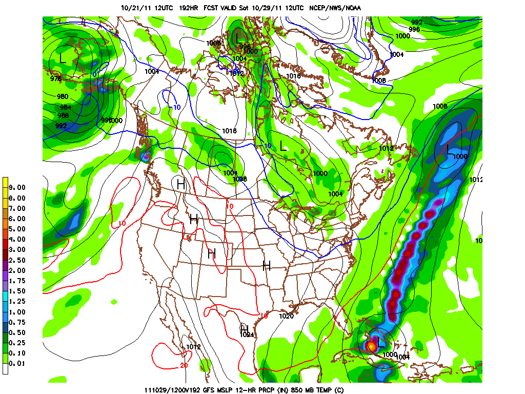
Although the modeling has been anything but consistent in the timing of a major event next weekend or late in the week, it has been very adamant about a MAJOR system forming as a result of yet another major trough amplification here into the east. What I'd like to show y'all is the timing differences of the GFS all progged for the same time next Saturday morning. The 1st map is from yesterday's 06Z run, the last is the latest 00Z run. Here goes.....
06Z Run
12Z Run
18Z Run
00Z Run
Believe me on this as I cannot access the prior runs, but the 00Z run from Friday had a major nor'easter complete with PA mountain snows up through New England! This latest run is a bit more phased bringing in warm ocean air from the Atlantic. Either case, there is plenty of energy and cold air that must be resolved for next weekend! Whether it be during Friday Night Lights, Trick or Treat Night, or the last weekend in October, someone in the eastern mountains WILL see their first real snows of the season....I do believe that. And it could be as close to us as the higher elevations of Center and Union Counties of central PA. Here are the coldest progged 850 temps for next weekend....cold! Those 1 mile up temps translate to temps in the upper 30s and low 40s here in our area and near freezing for the mountains of PA! But look west of the purple and note the flood of mild Pacific origin air across O Canada. This slap of cold will be a transient shot as the pattern is still quite progressive.
By the way here is the Euro's take on next weekend! First the 850 storm location...man if this were January I'd be licking my chops and touting a crippling blizzard-cane for Harrisburg!
06Z Run
12Z Run
18Z Run
00Z Run
Believe me on this as I cannot access the prior runs, but the 00Z run from Friday had a major nor'easter complete with PA mountain snows up through New England! This latest run is a bit more phased bringing in warm ocean air from the Atlantic. Either case, there is plenty of energy and cold air that must be resolved for next weekend! Whether it be during Friday Night Lights, Trick or Treat Night, or the last weekend in October, someone in the eastern mountains WILL see their first real snows of the season....I do believe that. And it could be as close to us as the higher elevations of Center and Union Counties of central PA. Here are the coldest progged 850 temps for next weekend....cold! Those 1 mile up temps translate to temps in the upper 30s and low 40s here in our area and near freezing for the mountains of PA! But look west of the purple and note the flood of mild Pacific origin air across O Canada. This slap of cold will be a transient shot as the pattern is still quite progressive.
By the way here is the Euro's take on next weekend! First the 850 storm location...man if this were January I'd be licking my chops and touting a crippling blizzard-cane for Harrisburg!
And the 850 mb temps a short time after this storm passes us, but New England gets pounded with a heavy wet snow! I know...I know...who cares about New England! Well my buddy Myers loves NE as do I (I'm partial to Maine, personally....interior over downeast), but his natural white carpet might get an early season start for Halloween weekend!
And of course, here is the infamous Woolly Bear's Take on next week's wx!
As for me I'm partial to the groundhog....PA's in particular!
And a final shout-out...not to any prognosticator, but to the 2011 Mid-Penn Conference Field Hockey Champion the CD Lady Rams! In an extremely entertaining game that featured long breakaways, disallowed goals, a captain conference with officials, and OT, the Lady Rams defeated their nemesis (and everybody's for that matter), the perennially talented and outstanding LD Lady Falcon team by a 1-0 margin. Congrats to the coaches and the players who earned their medals in a most exciting contest!
Have a great week's end!
Smitty
AA: Major wx event sometime late next week or weekend. Snow will fly nearby to the north, but not in our area...yet. Then the coldest air yet with blustery winds. But the cold will not hold as mild air will then erode the cold. I consulted with my furry friends for this! Also, congrats to the CDHS FHK team on their Mid-Penn Conference Championship!
Sunday, October 16, 2011
Batten Down The Hatches
It is now becoming painfully obvious that the tropical troubles that are presently in the Gulf will phase with the strongly digging trough and create a powerful storm for our mid-week period. I do not want to down play this event as gusty winds with fully foliated trees growing in saturated soil is a recipe for widespread uproots! The present satellite pic from Sunday afternoon shows the gathering tropical storm in the Gulf.
Note the clear skies to the north of the disturbed wx west of Cuba and northeast of the Yucatan. But this heat and humidity will fuel the digging shortwave and spin up one heck of a storm (988 mb or lower) that will begin to affect our wx by Tuesday afternoon. Here is the surface map for Tuesday afternoon.
And then 12 hours later during the midday period of Wednesday! The dome will be closed in Milwaukee or the fans will be bundled up in St. Louis for the start of the World Series Wednesday evening! The blue line you see is the 0C line at a mile. It will be cold to be sure in either location with the obligatory accompanying bone chilling breezes!
By Friday, the storm is pulling away up into the maritimes and the cold will be whisked into our region on strong and gusty NW winds. Friday night football this upcoming week will be a cold evening to be sure!
Here is a better picture of the cold 850 mb temps. From this point, I'd say temps in the low 40s at kickoff and falling into the upper 30s by the end of the game for Friday Night Lights!
The storm that will be developing for this week is compliments of a deep 500 mb trough that yesterday I believed would hold back and bundle some of its energy to "phase" more with the tropical energy and sure enough, it does seem that the GFS wants to do this. The UKMET actually has an even deeper east coast bomb with greater phasing of the heat, humidity, and the upper air energy! I still believe the bundling of the upper energy is still not completely being handled by the modeling at this point, but it is better than yesterday as we get closer to the actual event!
And as I said yesterday, this trough will not lock in, but is transient and by Sunday, temps will be moderating, but another deep trough is on the docket for the subsequent week as October will end up being slightly below normal temperature wise for the month. That is a trough with an even colder source region of air. Follow the isobars (black lines) up from PA and look where they originate! This is a true shot of Arctic air if this model verifies for the last week of October! Brrrrr...
But it is October! And a precursor of things to come for the next several months of dark days, colder wx, and political bickering and grandstanding as we are about to reach the 1 year point to the next presidential election. Hopefully we have just one last "lame duck" year of incompetence running the executive branch of government. But who will be the challenging ticket to oust the present occupant of the White House? Will it be Romney-Christie? How about Cain-Gingrich? Whomever it might be, they will have quite a mess to mop up.....and there is no doubt about that either!
Enjoy your Monday!
Smitty
AA: Strong storm to develop mid-week followed by some cold weather for the end of the week. After a brief warm-up the end of this weekend, next week will also be cold and getting colder it appears. Just over one year until another presidential election! Can you believe that!?!
Note the clear skies to the north of the disturbed wx west of Cuba and northeast of the Yucatan. But this heat and humidity will fuel the digging shortwave and spin up one heck of a storm (988 mb or lower) that will begin to affect our wx by Tuesday afternoon. Here is the surface map for Tuesday afternoon.
And then 12 hours later during the midday period of Wednesday! The dome will be closed in Milwaukee or the fans will be bundled up in St. Louis for the start of the World Series Wednesday evening! The blue line you see is the 0C line at a mile. It will be cold to be sure in either location with the obligatory accompanying bone chilling breezes!
By Friday, the storm is pulling away up into the maritimes and the cold will be whisked into our region on strong and gusty NW winds. Friday night football this upcoming week will be a cold evening to be sure!
Here is a better picture of the cold 850 mb temps. From this point, I'd say temps in the low 40s at kickoff and falling into the upper 30s by the end of the game for Friday Night Lights!
The storm that will be developing for this week is compliments of a deep 500 mb trough that yesterday I believed would hold back and bundle some of its energy to "phase" more with the tropical energy and sure enough, it does seem that the GFS wants to do this. The UKMET actually has an even deeper east coast bomb with greater phasing of the heat, humidity, and the upper air energy! I still believe the bundling of the upper energy is still not completely being handled by the modeling at this point, but it is better than yesterday as we get closer to the actual event!
And as I said yesterday, this trough will not lock in, but is transient and by Sunday, temps will be moderating, but another deep trough is on the docket for the subsequent week as October will end up being slightly below normal temperature wise for the month. That is a trough with an even colder source region of air. Follow the isobars (black lines) up from PA and look where they originate! This is a true shot of Arctic air if this model verifies for the last week of October! Brrrrr...
But it is October! And a precursor of things to come for the next several months of dark days, colder wx, and political bickering and grandstanding as we are about to reach the 1 year point to the next presidential election. Hopefully we have just one last "lame duck" year of incompetence running the executive branch of government. But who will be the challenging ticket to oust the present occupant of the White House? Will it be Romney-Christie? How about Cain-Gingrich? Whomever it might be, they will have quite a mess to mop up.....and there is no doubt about that either!
Enjoy your Monday!
Smitty
AA: Strong storm to develop mid-week followed by some cold weather for the end of the week. After a brief warm-up the end of this weekend, next week will also be cold and getting colder it appears. Just over one year until another presidential election! Can you believe that!?!
Subscribe to:
Posts (Atom)