Saturday, June 24, 2017

Train, Train

I'm up early this Saturday morning thanks to a train!  But not what most think of when they hear the word "train".  I'm talking about training cells of convection!  The rain has been pounding down for a few hours here at my humble abode and has awakened me from a deep slumber.  The sound of large drops striking our sunroom's glass is actually quite loud.  Hence, my awakening!  Of course, I scoped the radar and from there, here I sit studying the weather...again!  Here is how training showers depict on a computer model for precip output...note the train is a'rollin from West-by-God-smile-when-you say-it-Virginia to New York City...
But by the time when many of you peruse this, the train will be long gone!  And a glorious air mass from our neighbors to the north will be invading our country.  The strongest part of the anomalous cooling will be to our west; however, we here in PA will benefit with cooler and much drier air for the next several days.  Note the below normal temps in the Dakotas, MN, and WI for Saturday...
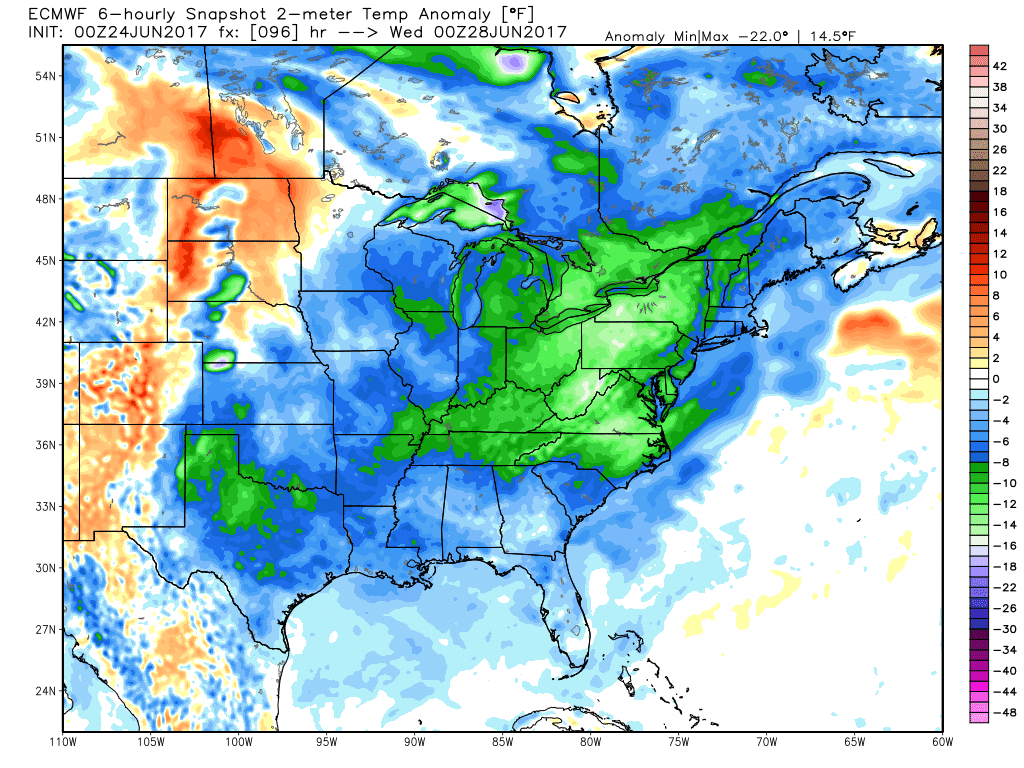
By Tuesday, the coolest of the summer temps will arrive here in PA...take a look...
Not only is it cool, the air will be very dry!  Here is a map I seldom show; precipitable water in a column of air.  This is a metric of essentially how much water could be squeezed out of the air if all of the moisture was to precipitate out.  In the winter, PW is quite low; in the summer, it has the potential to be quite high, especially in the tropical air masses.  Look at how low the PWats are for Wednesday am...but also note the stream of moisture advecting northward from the western Gulf to Lake Winnepeg!
So by next weekend, the heat and humidity both return to us here in PA...
 
In fact, the map above shows the warmth returning by Thursday!  And by next Saturday...well...here ya go...back in the "yuckies, muckies, and stickies"...note the anomalous humidity as per the "PWats" training directly over our lovely commonwealth!  Also note the 2 areas the model believes storms will be likely; just west of my son in STL and over God's Country in northern PA.  (Might be some blown out streams Goldy next weekend...?!)
 
As for July...here is a quick look as per the CFSv2...but don't get too excited as this is the first time it has shown such a "cool" signal to the middle part of the country into the east...too much to show, but the last several runs of the climate model was showing widespread warmth across the CONUS...but is that surprising?  Even the modeling has a warm bias in these politically charged times of global warming!  Ha!

OK...enough!  I need another coffee with my MCT.  Now, some of you might be wondering...probably not...but MCT?  Medium Chain Triglyceride...another story for another day!  Enjoy your weekend and the the invading train of cool to roll through our state this upcoming week!

And enjoy this throwback to when I was a kid!

Smitty

AA:  After the overnight rain that brought up to two inches in some parts of our area, a much drier and cooler air mass will pay us a visit for the next 5 days!  Highs in the upper 70s to low 80s with lows in the mid 50s!  I think Wed am, there will be temps in the 40s in south central PA!  But not at KMDT as that is the official reporting station and we wouldn't want such cool temps being officially recorded!  Good mowing and landscaping weather to be sure!  And Yokes...good paver laying as well! 

Thursday, June 22, 2017

Consistent Cindy

I'm doing back to back posts to show you how consistent the models are or are not from 18-24 hours ago.  I will show you the current outputs from the 3 global models and the one tighter grid model that I showed you yesterday.  Model consistency is something that leads to forecasting confidence.  For me, it's but a hobby; for many, it's their bread and butter!  In addition for this weather thing being my hobby and since I've been doing this weather watching thing all of my life since I was a "crumb-snatcher" (an affectionate term often used by my wife), when a plume of tropical moisture surges northward towards a diving trough from Canada, be aware of heavy downpours and training convection here in the Mid-Atlantic!  I've seen it many times before and will see it many times going forward.  So, here are the total precip outputs all valid for Saturday morning...the same time frame I showed you yesterday.

First the Euro...
Next the GFS...
And the O'Canadian...note the "dome" over the PA turnpike from Breezewood to Bucks County!
Lastly the higher resolution NAM...
I believe the message here is expect some fairly robust precip in these parts (much needed I might add) and there is a possibility, or more like a probability, that locations a mere 50-100 miles apart will see a vast difference in rainfall totals.  That is to be expected with convective, tropical systems.  Here is the most recent outputs from the storm tracks of the center of lowest pressure (Cindy's remnants) from numerous models...
And the top view of how Cindy and her associated deep moisture looked early this Thursday morning...the center of lowest pressure located just northeast of Houston...
So from observing the models and numerous past similar synoptic set-ups atmospherically, I expect Friday to be a "rain-out" with on/off heavy showers and even a few thundershowers with the bulk of the rain departing by mid-morning Saturday...by the way, this Sunday looks to be a "Chamber of Commerce kinda day!  Enjoy!

And enjoy this tune about what's happened to some extent the last several hours down in eastern Texas and other parts of the deep south...

Smitty

AA:  Warm and increasing humidity on Thursday sets the stage for a washout for Friday with about 1-2" of rain by Saturday morning.  Front pushes through and much drier air for Sunday through the bulk of next week...

Wednesday, June 21, 2017

Here Comes Cindy

By now, most of y'all are fully aware of the impending landfall of TS Cindy somewhere near the TX-LA border along the Gulf of Mexico.  But I've seen these plumes of deep tropical moisture translate north and east once they move towards more northern latitudes.  Since yesterday, the amounts of precip on all models have increased for our region.  But the exact location has been wavering back-forth between a I-80 to a US 40 line.  About the geographical middle ground between those 2 east-west roadways is KMDT.  Right now, the guidance would suggest about 0.75" of rain should fall, mostly during the daylight hours of Friday...here are the various models...

First the Euro...
Next the GFS...
And the final global model I'll share is the O'Canadian...
And the smaller gridded NAM...
So, it looks as if there will be some rain, but just how much is still a roll of the dice as of now.  Gut feeling deep moisture with approaching height falls that may lead to record coolness early next week, I believe we are looking at at least 0.50" with 1.5" not out of the question.  Time will tell...Here are all of the plots as of today with the track of the storm...
And here is how deep this trough will be at its greatest deviation from norms next week (Tuesday)...that is quite the trough for this time of year!
OK...back to more computer work here at school.  I just took my lunch to study this system and share some of the numerical guidance with my faithful readers (after a beautiful stroll outside in this glorious sunshine)!  So, with that said, I'll leave y'all with a Merle Haggard classic...enjoy!
And enjoy this beautiful afternoon!

Smitty

Wednesday, June 14, 2017

Remembering Agnes

45 years ago this June, a Gulf of Mexico storm evolved into a nasty tropical weather system that wreaked havoc all up and down the east coast of the US.  I was 9 years old at the time and I remember very well that weather during the early portion of our summer vacation.  Horses being led out of barns threatened by the rising creek that drained Silver Lake; the lake upon which our house was located.  (Ironically, we got very little water in our basement during Agnes!)  My parents' 1967 Chevy Impala flooded when parked down near Lewisberry.  Helping in Harrisburg removing mud from basements by wheel-barrowing debris up planks laid atop of the steps...Just so many memories of the impacts of Hurricane Agnes...and the Euro is hinting at a possible tropical development in the Gulf early next week...First a look back at Agnes in terms of the tropical rains...
The system essentially had a tremendous amount of overrunning precip here in PA and NY as cool dry air was attacked by this slug of tropical moisture.  A tremendous amount of rain fell over the Susquehanna watershed and that water had to flow past Harrisburg!  Take a gander...

The Walnut Street bridge used to be a one way auto bridge out of the city to the West Shore.  After Agnes, it became a footbridge only!
Now the track is was very different than where the Euro is hinting at a possible land-falling system...

Note where the Euro has a 40% probability of development next week...
And the total precip that the model is suggesting...follow the path of heavy rain from the Gulf into east TX...but from there...?

Also note in the graphic above the lack of precip here in south central PA.  But there will be a chance of us getting hit with a thunderstorm Sunday evening as a cold front will progress through the state in the early morning hours of Monday...A warm weekend followed by some pleasant O Canada air once again!
OK...gotta run.  But of course I'll leave you with a tune that might? be appropriate for our Gulf coast states at the very least sometime next week...

Smitty

AA:  Looking at possibly a tropical system forming in the gulf later next week.  As for here, just a chance of some heavier rains Sunday night into Monday as a cold front pushes across the state.  Definitely drying out from the last few days and the next several days...

Sunday, June 11, 2017

Oscillations and our Weather

As I sit here striking the keys with a slightly waning gibbous moon shining down upon me, I of course was thinking of the upcoming week of weather.  Again, if you want the cliff notes version, drop to the bottom of this post and peruse the AA I compose for my good buddy Timmy.  Otherwise, check out my reasoning for my beliefs...

Today, I want to focus on what I believe is the primary driver of the atmospheric engine...the Pacific Ocean.  Since water has greater density than air, water has a much greater influence in terms of distribution of heat energy across the planet.  And the greatest movement occurs in the equatorial Pacific.  Most, if not all of you reading this have heard of El Nino/La Nina...the warming and cooling of the Pacific Ocean.  Think of the Pacific basin as a big bathtub and the slow global sloshing of the water back and forth not too different than when you were a kid playing in your own little bathtub!  Here is the forecast of the ENSO (El Nino Southern Oscillation) from various models...


Most are predicting a slightly warmer (El Nino) Pacific in the upcoming months...here is the current Sea Surface Temps and from the recent past...note that since April, a slight cooling has occurred off the west coast of South America...this is normal.
But now, I want to share with y'all another lesser known oscillation which I believe also has a major impact on our wx here in the states.  The Madden Julian Oscillation or the MJO.  The MJO is essentially a rainfall pattern in the Indian and Pacific basins.  Monitoring the movement of these precip patterns, there seems to be a correlation to global wx events (SE Asia monsoons, flooding rains in the western states, arctic outbreaks...you get the picture...). Over the recent years, computers have correlated a "phase" of the MJO and the subsequent weather here in the US both in terms of temps and precip.  It is my belief that the temperature response is actually quite reliable.  With that said, here is the MJO forecast...note it is clearly moving into Phase 1 & 2!  Start at the green and follow with the dark gray shading...

So Smitty...what the heck does all of that mean?  Here is Phase 2 temps for the states focusing on May, June, July months...
Phase 2 shows a slight cool bias east of the Mississippi...and the modeling seems to agree that a cooling trend will occur after a brief stint of heat...normals for Harrisburg at this time of year are highs in the low-mid 80s and lows in low to mid 60s...
So it appears the atmospheric response once again to the MJO will correlate nicely here in the eastern US...time will tell,,,here is the surface map as of early Sunday morning...with a low to the north and the Bermuda High flexing its muscle, a warm to hot west to SW flow will result advecting heat to the east from the desert SW states...humidity will only slowly increase through the week...
But by Thursday, a big Canadian High will work its way across O Canada and push a cooler NE flow into our region here east of the Appalachians...take a look...
So why did I go over all of that?  I just wanted y'all to know that there is so much that goes into the weather prediction game that often goes completely unnoticed by the general public...and I love this stuff!  By the way, with a positive PNA, that too often causes a net cooling here in the east...Huh?  Take a look...
I just find all of this fascinating...and for those of you who made it this far...I'm sure you do too!  And good for you...and THANKS for reading!

Now for those of you who just like the song...here is a nice "Back and Forth" oscillation of two outstanding vocalists...enjoy!

And enjoy this brief heat wave; rest assured a cooling trend will occur shortly afterwards...(I think?!?)  Ha!

Smitty

AA:  Hot and dry through Wednesday with increasing humidity.  A good time to catch up with your mowing accounts!  Then moving into a cooler and somewhat damper time, but not too wet...here is the total precip for here in PA over the next 10 days...

Friday, June 9, 2017

Summertime!

The 3 warmest months climatologically at this latitude are June, July, and August.  Well, to this point in the month, it has been anything but warm...take a look at the temperature anomalies from June 1...
But things are about to change as forewarned last week...summertime heat and humidity will make inroads without resistance over the next several days...and as many of you know...once the deep moisture/humidity make it into these parts, it will be until September until it will willingly depart...SUMMERTIME!

Here are the departures from norms for the next week to 10 days...
An east coast heat wave to be sure...here is a an easier day to day graphic for the predicted temps over the next 10 here in our region...focused on KMDT...
The green bars are the overnight lows...notice they are increasing.  That indicates a major increase in in the humidity!  Although the daytime maxes are decreasing, the comfort index will become somewhat undesirable as we proceed through the week.  Summertime!  I guess I'll be initiating our  AC next week; no more York County AC; simply recycled AC!  In case you're interested, here is the 46 day Euro Temp anomalies based on its ensembles...check it out...

So Smitty, what does that map above indicate?  SUMMERTIME!  A wet pattern to develop...and they are in desperate need of precip in the SE states...in the SE quadrant of the USA.  A persistent trough/wet period into the PAC NW...And for us here in PA, periods of heat and humidity and then a bit of cooling with normal precip.  The biased is to the warmth...

Side note... I'm blogging tonight since there is no NHL to view and my Os are always BLACKED-OUT at my humble abode?  I will never understand that...?

With all of that said...SUMMERTIME!  Enjoy Norah...she sure can tickle those ivories...


And I hope y'all enjoy SUMMERTIME.  Before you know it, I'll be issuing frost and freeze advisories, but that is putting the horse waaaaaaay before the cart!  Enjoy these warm months!  And by the way, GREAT AMERICAN ECLIPSE...Be there or be square...
Happy Week's End!

Smitty

AA:  Enjoy this evening and Saturday in terms of both heat and humidity (or lack thereof!).  Then it is suddenly SUMMER.  Heat AND humidity!  Norah Jones playing the piano is awesome; take some time from your busy life to appreciate!  


Sunday, June 4, 2017

A Little Help From My Friends

As many of you know, though a Red Land boy by hook and crook, my Sundays carry me to Lancaster County for faith and family and newly acquired friends.  Today was no different.  But since we are now in the month of June, our church services commence at 9 am thus causing a slight change of our Sunday am routine.  With all of that said, I decided to venture to one of my favorite venues for our Sunday noontime meal that I haven't visited for many a Sundays.  That's when we crossed paths with "Jimmy" (the name has been changed to protect the innocent).  It's actually been several months since "Jimmy", Kay, and I have discussed varying topics from politics to Pennsylvania; fermentation to family...you get the idea.  Of course, at some point, the weather came to the forefront and I made the comment that the pattern is going to change; likely this upcoming weekend..."Hey, maybe I should blog about that!"  Thanks "Jimmy"!  That's the saga for the first part of the "help from my friends"...

It's been a cool, damp last several weeks...take a look...please understand 2 things; the map below is a 30 day average where 2°C is quite a deviation from normal and that includes a stretch of 3 days with record and near record warmth!

But I do think the pattern is about to change...but not until this weekend.  First, we will endure another unsettled week with cold air aloft allowing for afternoon showers and even T-storms to pop from time to time...here are the 500 mb heights the next several days relative to the norms...

First Tuesday am...deep trough right over PA...
And that trough even strengthens and deepens by Thursday...
Even on Saturday, the cold air aloft will linger...but it is starting to weaken and pull back north towards Hudson Bay...
Finally by Sunday afternoon...boom...ridge and pattern change!  Welcome Summertime!
And using my hazy and foggy crystal ball, it looks warms from that point forward...not necessarily hot and humid, but summerlike to be sure!  I'm sitting here in my sun room WITH A SWEATSHIRT on typing this presently; not normal for early June.  By the way, it's an Baltimore Orioles sweatshirt if that is any consolation?!?  And the climate model seems to think we will have a summer...but I don't put much stock in the CFSv2...just my opine.

July...
August...
Now the 2nd part of the "help"...Jimmy always comments that he likes the music I incorporate into the wx discussion.  In fact, I get more comments and feedback about the music than my wx insights...hey, that's all good with me!  I'm glad you enjoy the tunes!  So lately, Kay and I have been listening to numerous Alison Krauss tunes and suggested that the ditty below would be a good choice for the pattern change!  Gone...Gone...Gone... (Done moved on) with this stubborn upper level cool pool for the last 3 weeks!  And to that I said..."Good Choice Crazy"!  Enjoy!


Summer Solstice Wednesday June 21, 2017 at 12:24 am EDT...just thought you'd like to know.  Also, do don't forget about the Great American Eclipse August 21, 2017...see below...
Okay...I'm out.  

Smitty

AA:  A pattern change this weekend.  After this week of cool and unsettled wx; summertime will return Sunday and for the foreseeable future. The mowing demands will slowly abate...then it's time to play in the creeks and streams with your 2 precious wonders...including your fido democrat!