However, before we venture down the road into the medium and longer range, a potentially hazardous event lurks for early morning commuters Monday. As I alluded to with many of you over the weekend, I was concerned about the potential for freezing rain late Sunday into early Monday. Fresh snow cover helps hold cold dense air near the surface and thus, any light precip or drizzle will freeze on untreated surfaces quickly. And a light SE flow will develop this evening with an approaching storm from the west and with it marine upsloping moisture laden air from the Atlantic...a perfect recipe for black ice in these parts. Please be aware if out and about late Sunday into early Monday before temps rise and we begin our much above normal week temperature-wise. The NWS has actually been very proactive with this situation as shown below...
As for the medium and longer range, once again mixed signals appear in the global models. The Euro has done a complete 180º turnabout from yesterday with its NAO forecast. The most recent run trends the NAO back to the dreaded + state for any who want more winter. However, its last 2 runs had the NAO tanking. Take a look...
The GFS is actually more bullish on the return of winter for the next few weeks...Note the consistent negative slope the last few weeks and how we have actually observed colder temps with some, albeit minimal, wintry precip. Come to think of it, that graph below resembles some of my stock picks for 2011! Ouch!
And here is the GFS' take on the AO as well...Note how the AO is forecast to tank, but then head back towards a neutral signal...time will tell.
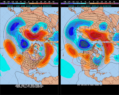
I will say this. Yesterday, the Euro actually had 2 storms on its docket for us here in the eastern US on days 7 and 10. Now, it has backed off. Note the difference in the upper air pattern between the Euro and the GFS for the period 8-10 hence. (The GFS is on the right.) Note how much colder and deeper the trough is with the GFS over eastern NA. With that very important difference, both tend to agree with the global pattern in the norther hemisphere; low heights over AK, ridge over HI, ridge over Siberia, deep trough over western Pacific. If...and that is a big if, that cold over AK can be displaced SE, the pattern is set for a rocking February!
Let me just quickly show you the GFS' take on things at a few points into the future...First, fast forward 7 days...Actually the ensembles have fairly good agreement as shown to the right. The white line is the mean position of all 20 members of the ensembles.
Now, at 10 days...This is a very cold pattern! A direct discharge of Arctic bliss at the Lakes, Mid-Atlantic and Northeast...There is still decent agreement amongst the ensemble members...
Finally at 384 hours, or 16 days into the future...a half of month! Usually a crap shoot at this time frame. A deep broad trough over the lower 48; not as cold, but still potentially stormy with wintry precip abundant with this upper air flow. Also note the anomalously low heights just upstream from us suggesting a continuation of a colder and stormier pattern long into February...Again, only time will tell. The map on the right accurately portrays why these model runs are referred to euphemistically as a "spaghetti plot".
I leave y'all with this. Whatever might occur into the future, enjoy our recent change of landscape scenery as it will not be around past mid-week. Here is the snowfall as determined from space as of Saturday, January 21, 2012...or 01-21-12! Officially, KMDT recorded 4.5" of snow with 0.51" liquid equivalent producing a surprisingly low ~9:1 ratio...nearly the exact same measurements at my humble abode just a short 2.5 miles SSW of KMDT.
21-12! That was a great album from the 70s. Now I know many of you have no idea...but just take a listen to a cut from this classic from Rush, a band that hails from O Canada and features some outstanding percussion from one Neil Peart! Be careful when you play this if you are only half awake because you and your neighbors WILL BE FULLY AWAKE once played. Look into the entire album 2112 if you liked this song.
Smitty
AA: Some light freezing rain into early Monday. Then becoming milder this week before getting wilder for February!


No comments:
Post a Comment