But we will have one last burst of snow as a deformation band sets up somewhere near the Lower Susquehanna Valley as the storm begins to pull north and east. Thunder-snow was reported around the 1 pm hour in the Harrisburg area and visibilities are less than 0.5 mile for several hours this afternoon. Here is a visible satellite image of the storm....note the bubbly clouds that are precipitating heavily and the "eye" that is trying to develop in the "snow-cane" that we experienced here today!
And here is the IR satellite image showing the classic comma shape for this incredible cyclone. The pressure of this system should attain ~992 mb or lower at the 40th parallel! It will deepen further as it pulls away and thus winds will strengthen overnight.
The NWS office at State College has added some new graphics for wx obs over the past couple of days. Here is the visibility observations over the last 2 days. Note the lowering ceiling and low visibility during the height of the storm. Note how the last hour obs the visibility is improving; how depressing! As of 5 pm, KMDT has received 1.38" of liquid creating our 5" snowfall. Doing the math equates to ~4:1 ratio; a very wet snow! Do keep in mind that ~0.25" of that liquid fell prior to the changeover to snow early Saturday morning.
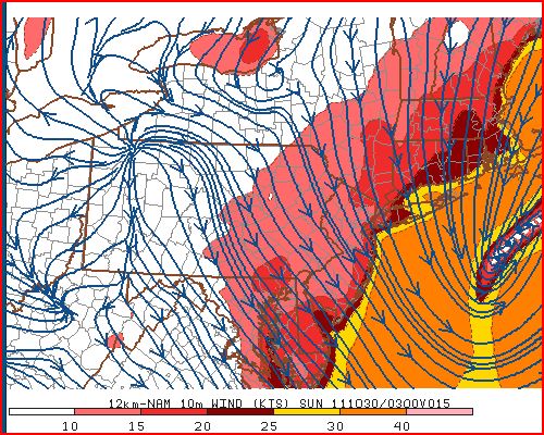
Here are the modeled winds for just before midnight.....
And here are the forecast lows for Sunday morning...quite a cold morning for October 30. The previous record minimum is 24F in 1965. We will be close and should get to it the skies clear out by say 3 or 4 am. The winds would also have to abate.
This storm's impact will be affecting many people over the next few days. It's one thing to lose power when temps are mild or even warm; its another story to lose electricity when temps are in the 20s at night! Here is a county by county count of service outages for both PPL and Met-Ed as of 5 pm!
And Met-Ed's site was overwhelmed for part of the afternoon! Trust me, there were over 10,000 outages in York County alone as of 2 pm. I hope y'all can read this and therefore have not lost power!
Well as the storm winds down (as of 5 pm, KMDT has officially received 6.0" of snowfall), I will settle back in front of the TV to view a punting clinic and turnover delight from State College, PA under the guise of a Big Ten football contest!
Enjoy the remainder of your weekend.
Smitty
AA: A record breaking snowstorm for October 29! I hope you guys don't lose power! Be safe if you venture out and turn off the water!


No comments:
Post a Comment