Smitty's attempt to educate and to a much lesser extent, entertain, about all facets of life; but primarily the meteorological and the climatological aspects of the earth sciences.
Saturday, May 14, 2011
Historical Flood on the Lower Mississippi River
You know the news cannot be very good when the word "historical" is used twice within the same month! As many of you are fully aware, the Mississippi River drains a large region of the US. It is the 3rd largest river drainage system in the world; only the Amazon and the Congo drain a greater land area! Old Muddy drains 41 percent of the 48 contiguous United States, including all or part of 31 states and 2 Canadian provinces. The excess rains of the mid-Mississippi Valley and the Ohio Valley during march and April are now coming home to roost! That is one awfully large funnel collecting precip to flow past "Red Stick" and New Orleans.
Extreme flooding along the Mississippi in 1927 moved congress to pass to legislation a year later authorizing construction of levees, floodways, and a variety of other landscape modifications to control the flow of the Mississippi River essentially to prevent a more severe flood scenario. One such engineering design was to create spillways along the levee system to relieve pressure further downstream on the levees and reduce the possibility of a catastrophic flood. The release of the water upstream back in the 1930s flooded primarily farmland and actually enriched the soil "naturally" for subsequent agricultural years. However, today, there are numerous homes and businesses that lie in that same area due to the development of the flood plain. The graphic below shows how opening the the Morganza Floodway back in 1973 inundated the adjacent land areas as compared to a non-flooded view.
Below is the non-flooded view a few years later. Red is essentially farmland and vegetation in this older landsat image:
Plans by the governor of LA (no that is not Tommy Lasorda all of you baseball junkies) is to open the floodway and inundate the areas north of Baton Rouge. This would divert the flow of the river south and west of the major population centers in central and southern LA. Although tremendous hardships will ensue, this option seems to be the lesser of 2 evils. The map below shows the potential flooding that awaits southern LA by opening the floodways.
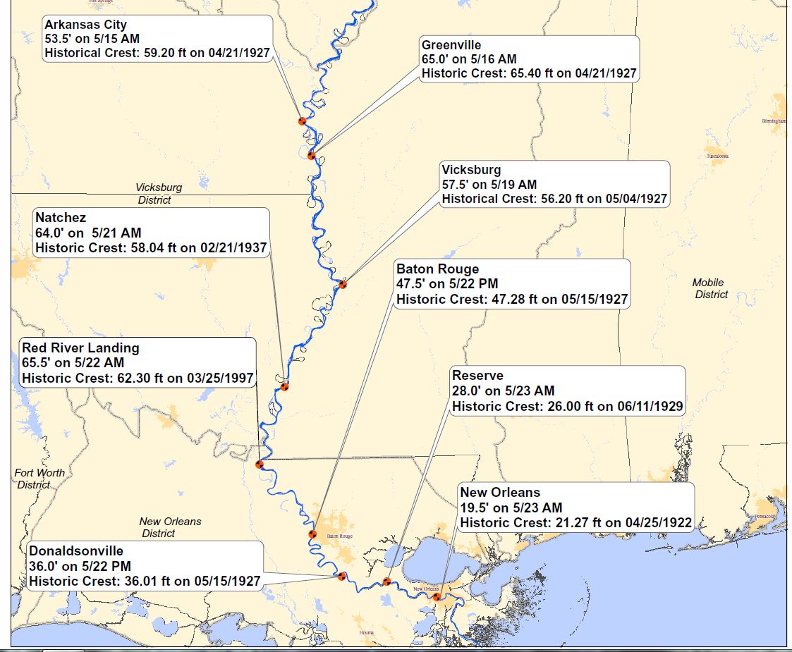
This map below shows just how "historical" this flood really is. The crests are astounding! Nearly 3 million acres of farmland devoted to corn, soy, wheat, and cotton are not arable this year due to the extreme flooding. As a result, therein lies another soft commodity play for those of you who enjoy to monitor futures contacts on such things. As for me, I believe I'll try to beat the favorite in the upcoming Preakness next week at Hi-Ho Pimilco!
For those of you who this really interests, the video clip below which will take 3 minutes of your life, gives a very informational overview of the levee systems and the like as developed by the US Army Corp of Engineers:
As for our local weather, rain will be present in all of the next several days to some degree. By Thursday, the gardens and lawns will have received ~2.00 inches of nature's nectar as per the MREFs as shown below. It will be a dreary time, but how appropriate as we enter the local election primary this Tuesday.
Just in case some of you are still confused about the Tommy Lasorda comment, many of us including yours truly have this infatuation of the sport of baseball. When you see the abbreviation "LA", one automatically thinks of the Dodgers and their glory days being ruled by Lasorda. But the governor of LA, Boddy Jindal, who some have touted as the next US president, has about as much chance of becoming president as my favorite baseball celebrity juxtaposed with one of the better managers baseball has ever seen!
Have a great week's end!
Smitty
AA: Info on Mississippi River Flooding and a rainy, wet week forthcoming for our area.


No comments:
Post a Comment