For lovers of winter weather, it doesn't really look too good for us living here in the sub-tropics of North America! We've been spoiled the last couple of years in terms of cold. As for snow, we had a few promising storms, but our snowfall was overwhelmed by the Arctic cold and dryness. But this year to this point is a different story. If you think it's been mild; well you're correct! Take a look at the graphic below. There has been only 3 DAYS BELOW NORMAL in December to this point; 3 DAYS! That saves on heating costs and drives down the natural gas prices, especially painful if you are invested in such commodities! Only December 12 was "cold" (-5ºF below normal) this month and that was thanks to a cold morning low of 19ºF! The afternoon temp responded to 40ºF with bright sun...not too hard to take! Take a look...

Although snowfall and snow cover is "normal" to this point, it just seem like winter has not made much of an appearance here east of the Mississippi. The graphic below shows the "normal" snow cover for the northern hemisphere to this point compared to the last 10 years. In November, we were way ahead of what promised to be an early onset of winter. That did not pan out too well! Usually snow cover breeds cold and more snow...kinda like winning breeds winning...well sorta....
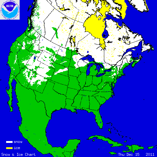
But here is our below normal snow cover to this point...
Compare that to last year at this time...a bit more expansive across the lakes and northeast!
And if you are waiting for anything the next week, well I'm not too sold on any storm delivering the goods for Christmas, although there is a potential for a storm on/around Christmas Day. Here is the maximum snow cover I could find from the GFS over the next 8 days. The map below is for next Friday. Clearly the GFS sees a storm cutting to our west taking aim for a snow event through the plains and into the western lakes. It appears as if Chi-Town will be experiencing a White Christmas. In the east, you best venture to northern new England to experience any bona fide snow and that is not even a sure thing!

And to make matters worse, the teleconnections of the Arctic and North Atlantic Oscillations are forecast to stay positive for the foreseeable future. Remember, a negative AO and NAO helps hold the cold in the east and promotes east coast snow storms or at the very least, creates conditions conducive to such weather events! Here is the "mild" looking NAO through the new year. Positive and trending even more so...ouch!
The AO is no better for snow lovers...
So there is the quick take what appears to be a "Green Christmas" in these parts. Here's hoping that at the very least, we have a "Green" weekend prior to the Christmas weekend as the CD Rams bring home the PIAA AAAA football trophy! Maybe D3 will begin to win more of these prestigious championships as the West Shore SD is discussing the merging of their 2 high schools into ONE SPORTS PROGRAM! This would save over a half million bucks! Man, I don't really see that happening, but it would create a rather powerful and formidable opponent in District 3! What the heck would their mascot be...the Centaurs? Wow!
(Please forgive my feeble attempt at doctoring an image!)
Have a great PIAA AAAA football finals week's end!
Smitty
AA: It's looking like a "Green Christmas" is in store...but there still is a small possibility of some snow on/around Christmas Day.


No comments:
Post a Comment