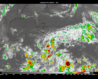
It will take some more time, but I am still convinced that the cluster of thunderstorms down in the Caribbean will become our 1st named tropical storm, Arlene, of the season. It should not become a "monster", but few storms do this early in the hurricane season. In fact, this, if it even does earn the honor of a name, may not achieve hurricane status. However, that does not mean it will not bring heartache to an area of our earth that needs no more of nature's wrath at this time. The heavy rains will produce major landslides in Haiti and the Dominican Republic along with Jamaica-mon. This is not a good week to have cruise plans in the Caribbean! The satellite below shows the persistent cluster of storms that may evolve into Arlene.
The Euro does develop a tropical storm with a closed low and rotary circulation by Tuesday. The Navy No Gaps model, (yes...even the Navy has an atmospheric global model!) creates an even stronger tropical storm by later next week. Shown below is the European's depiction by Tuesday. If that trough were a bit further east in the Atlantic and the ridge then further east as well, Florida to LA should be worried about that storm gaining strength and propagate northward.
In fact, that deep trough in the central Atlantic actually gets reinforced with a piece of heat that escapes from this disturbance in the Caribbean. In fact all of the global guidance suggests this scenario. Here is the GFS guidance for next Friday. Note the very deep cyclone in the Atlantic. It became that way as a piece of energy from the deep tropics phased with a wave coming off the continent to create quite the fish storm.

You all say...."well that's nice Smitty...but what does that mean for us?" Glad y'all asked! Essentially, we should remain in a relatively dry with seasonable temps to maybe even slightly above normal with such dry air in place. With the dry air, we cool off nicely in the evening but can warm up very quickly with the strong June sun. In fact, last evening at 7 pm, KMDT reported a dewpoint of 37ºF with an air temp of 76ºF creating a RH of 22%! Now that is dry! As for the strong June sun, today at "noon" which is actually 1:06 pm EDT today for Harrisburg, PA, the sun will have an altitude angle of slightly more than 72º! Now that is truly a "high sky". Sorry I digress.....the map below is the GFS 500 mb for next Friday as well. Note the strong winds 3-4 miles up flowing from the NW over PA. These winds can often lead to some surprisingly warm wx at this time of year assuming the northern plains are able to tap into the heat from further south. Couple that with downsloping off the Allegheny Front and we are looking at temps easily in the mid-80s...but I do not think 90ºF will not be attained. Our surface winds will be more northerly as shown in the map above. Do the counterclockwise thingy around that low off New England and we find ourselves breathing air straight from the Nordiques. Either way, this is not a conducive pattern to bring some now much needed rain to our area for the lawns, gardens, and fields.

On a side note, I've had many of you tell me or tell friends tell me "Man...look at the time he is posting". Well, there are a few reasons for this. Sometimes, the blog time uses Pacific time and sometimes it uses Eastern time......not sure why! But yes, I am a morning person and part of my routine is check out the global modeling and share my insights with y'all. Wx is 24-7; it is really that simple. When I miss a day's worth of computer runs, I feel that I am so out of the wx loop. I try to see little differences in run to run to look for pattern shifts, etc....I'll not bore you with details. But I love this stuff....and whether it is confirming my own thoughts through this medium or tweaking a PowerPoint presentation for my captive audience of adolescents for 3/4 year, I will try to best explain my thoughts on the topic at hand. That, plus I really don't have a life......many have also told me that I was more fun several years ago.....oh well! Now I'm just an old boring old weather weenie whose life revolves around his family and his 2 four-leggeds.

Have a great week's end!
Smitty
AA: Still monitoring the tropics for hurricane development. A bit of rain overnight Saturday into Sunday morning. But basically warm and dry for our area for the remainder of the week.


No comments:
Post a Comment