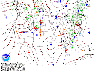
A southern branch upper vort max will actually phase with a northern jet stream feature and advance eastward through the Ohio Valley spiining up a pretty good cyclone over the Mid-Atlantic States. If this were winter, I'd be chomping at the bit! Instead, a rare possibility of severe thunderstorms could be occuring SE of the mountains near the dynamically induced Low Pressure system while snow flies in the northern mountains of PA, NY and northern New England. As this storm pulls NE, a cold front will advance from west to east, enhancing the upward motion offering the possibility of heavy rains and severe storms. It's not out of the question that a tornado will be spotted in the slight risk area.....especially the way this severe season has turned.
Note the 500 mb full phase between the northern jet and the southern jet. This will be a very dynamic system...

This most certainly bears watching as Tuesday's highs will become quite mild as the Harrisburg area enters the warm sector ahead of the approaching storm and the low passes nearly directly overhead. In fact, watch your home barometers tomorrow afternoon as the pressure falls could become precipitous ahead of the rapidly advancing cold front.....another interesting weather day to be sure!
Enjoy your Tuesday.....
Smitty
AA: Potential for heavy rains and severe wx Tuesday afternoon and evening.......


No comments:
Post a Comment