Smitty's attempt to educate and to a much lesser extent, entertain, about all facets of life; but primarily the meteorological and the climatological aspects of the earth sciences.
Not to be confused with Nor'easter! The inhabitants of the northeast quadrant of the US are likely growing weary of that term due to the atmospheric events of this month to date. From damaging gales early on to crippling snows most recently, March still has plenty of winter woes in store for those anxiously awaiting true springtime weather. The birds who feast from our feeders are a good barometer (and thermometer) of the cold as our black oil sunflower supply has quickly dwindled while the feeders are being decimated by those energy hungry winter weary feathered friends. There will be brief respites from the relentless cold; but the overall messaging from the modeling is cold and colder relative to normals as far as the equations can see. Please let me explain...
I'd like to start with the Great Lakes...2 graphics. First, the amount of ice on all of the lakes compared to normal for the entire winter...obviously much more than the last 2 years, but clearly far less than the record setting 2014 ice free date. (First week of June, Lake Superior!)
Next, the ice for just this year. Note the 2 peaks with the surges of bitter cold in late December and then again in early February. I believe we will add to those twin peaks by adding a 3rd max here at the end of March as the normal ice amounts quickly diminish at this time of year; but not this year!
Now I know many of you reading this are very curious as to the potential wintry weather for this upcoming week. Rest assured, it will be wintry! Let's put it this way; enjoy Sunday's rather benign weather as we may achieve 50ºF under mostly sunny skies! After that, the next 5 look cold and potentially stormy. When in a "blocking" pattern, the day to day changes are not so great in terms of temperature; the forecasting of storms is much more tricky. Here is what a blocking pattern looks like from 23,000 miles away...note the water vapor moving northwestward from the central plains up towards Edmonton O Canada! Also note the Arctic slide towards PA and the northeast US!
And I know many of you want a snow forecast. But until this energy over the west coast comes ashore, it will be difficult to determine the paths of lowest pressures. One thing to note, the southern jet stream is loaded with moisture as seen above. Note the flow from west of the Baja across the southern US, a real concern with cold arctic air in place! I circled using purple the vorticity (spin energy) that needs to be monitored for mid-week madness. That bowling ball off of Cali and that strong jet further south will interact; just how so is the big question! Again, note the NW flow over PA!
My fear is what just occurred in New England could just occur somewhere here in the Mid-Atlantic later this week...these snow totals were quite impressive!
Note the New England snow depth as of St. Patty's Day! Wow! There is mucho water in that glacier making for what should be an epic "mud & flood season" in the north country!
Quick snapshots of upcoming cold...5 day average of cold this upcoming work week...
Then, next weekend through the remainder of the month! Again, a 5 day mean! Brrr...
A one day snapshot of the day before Easter...col'easter! Not very nice for opening days for MLB in the eastern half of the country!
How about through April? Ouch...
OK...enough already...I know! By the way, how 'bout them Chesapeake Bay Retrievers! Enjoy this lesson ditty as you sing and dance and look for leprechauns this weekend! Enjoy!
Smitty
AA: Pretty darn cold and wintry to end the month of March...and likely into April! The mowing of the green will be delayed a bit, but certainly not denied!
Many of you who are reading this have heard me tout that although we thoroughly enjoyed a late February spring-like spell of weather that there were signals suggesting that the first couple of weeks of March had the potential to be ugly. Well, nor'easter #1 has come and SLOWLY gone away...sort of...still gusty here this afternoon! And later this weekend into early next week, storm #3 of this 1st couple of weeks will be on the agenda, but over the next 48 hours, storm #2 will be upon us. It is clearly a case of the GFS v Euro...but the Euro is trending westward from its earlier runs. The GFS has been rock steady wavering minimally with its axis of heaviest snows. One major difference between #2 and #1 is the antecedent cold that is currently present and was not with #1. With that said, snow is more likely rather than not...let's take a look. First, how the Euro is trending west...
Euro last night...
Euro this afternoon; slightly stronger storm and clearly farther towards the continent...
The morning run of the GFS...precip much further west and a deeper low...
And the current GFS run...precip shield more tightly woven towards the center of lowest pressures...
The NAM is quite bullish on the snow; but this model will vacillate before honing in on a final solution tomorrow midday. It clearly states "be aware"...
A Winter Storm Watch has been posted from the NWS...that advisory is just that...a WATCH! One thing for sure, the next 2 weeks will not see what we saw the last full week of February. This is certainly a colder than normal spell for these parts next couple of weeks...
Oh well...enjoy!
Spring is simply delayed; it will not be denied!
Smitty
AA: Watching yet another nor'easter; less feisty than Friday's, but still a concern. I'm quite concerned about a phasing nor'easter early next week! One storm at a time!
As I sit here early this Saturday morning sifting through reports of wind and snow reports, the howling sounds of March continue outside indicating the winds remain to buffet our humble abode. Friday afternoon, the winds were literally roaring in a much heralded lion-like fashion as KMDT reported a wind gust to 60 mph during the mid-afternoon! Power was never lost for any length of time;however, the constant reminder of surges suggested we were but one limb or tree from complete power loss. Thankfully, that did not occur. Whole gales were common all throughout eastern PA and hurricane force winds were measured just off the coast of both NJ and DE. And...oh yeah, ample snow fell in most of eastern PA to boot! How about a 23.6" trained spotter report just outside of Tobyhanna and blizzard warnings for northeast PA! Yes, this was one March nor'easter once again for the books! Here's how she appears this morning from ~22,000 miles up noting the water vapor in the mid-levels of this well mixed atmosphere...
The winds today will GRADUALLY subside, but gusts well over 30 mph will still be common during the daylight hours. Here is the Euro's depiction of max wind gusts later today. Note how the ridges show very nicely all though the central Appalachians...very cool!
But a large arctic high will nose its way SE into the eastern US by Sunday finally clearing our skies but still with a rather significant pressure gradient, the lion-like roar of winds will only be slightly tempered to a rather powerful purr reminding us it's early March; March 4th to be exact..."National Military Day" so to speak! Take a look...
As for the upcoming week, the 500 mb pattern is one filled with potential, but I believe the atmosphere just depleted its thermodynamic energy in one fell swoop with this very powerful nor'easter as pressures tanked rapidly Friday supporting this impressive and dynamic cyclone. But, be advised, this mid-level blocking pattern bears watching to be sure. The graphic below is a 5 day average of the mid-levels indicating lower than heights (temps) under higher than normal heights over eastern O Canada...often a stormy signature for late winter...
But both the Euro and the GFS don't show much storminess this week...here is the Euro's weakening storm to the lakes trying to spin up another coastal but the upper air support is seemingly absent this time around...but do be wary...
There will be a smidgen of cursory snowfall in PA, but the precipitation totals are quite manageable, especially with this upper air pattern! We can sure use this period to dry out a bit in these parts. The graphic below is a 10 day total precip as per the Euro...(note the lake effect showing up downwind from Lake Erie...!)
Here is the February precip totals for Philly...quite wet to be sure! Pittsburgh had its wettest February on record; time for a precip respite I would hope...
After a late Saturday crest, the mighty Susky will fall quickly this week as PA streams restore themselves back towards normal levels for this time of year...
OK...enough. You all know me, I could go on and on, but I need another coffee for further study of our amazing and wondrous atmosphere! So, I'll leave y'all with this 40 year old song! I can't believe that..."wind blows around in her hair and the flags on the poles..." and ..."He's a crazy lion..." ENJOY!
Smitty
AA: Weather to calm down by Sunday and generally cooler and drier than normal this upcoming week, but the upper air pattern suggests to be cautious with this benign outlook!
PS: It is truly with a heavy heart that one of my loyal readers passed from this world earlier in the week. Deb B would often email a brief comment back to me concerning my synopsis; the most recent being something like..."I don't care if it snows in PA as I'm basking here in Florida!" Now may Deb bask (and peacefully rest) in her divine abode.
Say it ain't so...oh no, Mr Smith! Well, don't shoot the messenger, but the global modeling has been hinting at this for quite sometime and I simply wanted to bask in the record breaking warmth of this past week. (Wednesday's 79°F was the all-time February max since official records began in 1888 at KMDT!) As so eloquently sung by Lindsey Buckingham and Christine McVie "...Yesterday's Gone..." and "...Don't you look back...", I must now begin to "think about tomorrow". And as we all know, March can always have a few tricks up her sleeve and this year looks to be no exception. Humor me for a brief post...
First the negative NAO blocking signal as shown by the Euro...this is a major block where shenanigans run rampant underneath. That is a huge anomalous block over Greenland with a closed low strengthening over PA. Now this is 7-8 days hence, but certainly does bear watching...
And the GFS shows a reasonable depiction of the surface chaos...
I always like to see what the analog package offers to get a sense of how the atmosphere might like to resolve itself with such anomalies using the CPC's super-ensemble analogs. I perused the the top 2 hits and they are somewhat amazing! Some of you will likely remember the Ash Wednesday storm of 1962! It must have been a doozy as I remember reading an article published by the USGS on this storm a few years back stating it was up to that point, the most damaging coastal event to the eastern US ever! That's saying something considering the major hurricanes that ravaged the east coast in the 30s and the 50s!
And this graphic remembering the Ash Wednesday storm looks similar to what both the GFS and the Euro seem to think might evolve...
And the 1958 analog though not the exact same week, a very similar pattern. A Cat 2 NESIS storm...
You see, Greenland blocks are very tricky, but they do tend to generate powerful and slow moving nor'easters. With the upper air synoptics in place coupled with relatively warm water off the east coast and an increasing sun angle, the necessary energy requirements, the players are indeed on the field for a March meteo monster! Here is an historical graphic depicting the surface low evolution of the 1962 storm that crushed the mid-Atlantic with heavy wet snows with the Shenandoah Valley being hardest hit. I hesitate to post this...but I will. Here is the somewhat consistent Euro for the past 3 runs now...this would be rather intriguing!
OK...off to watch the rain, low clouds, drizzle, fog, rising creeks...etc. You get the point. For my buddy Noah below...the Swatty should be well-behaved this weekend and start to recede by late Sunday evening...
I did have a couple of musical references, but this is the one I'll leave y'all with a slice of Americana...enjoy! And enjoy your week's end!
Smitty
AA: Rainy weekend; no $%!T Sherlock...right? Watching the first week of March...winter just might make a rockin' return!
After last evening's snowfall on already saturated ground, prepare for the inescapable quagmire about to ensue today and later this week as this morning's glorious white landscape will evolve into one of muck, mud, and mire over the upcoming week. As I mentioned yesterday, 2 days of likely max records coupled with more days with measurable precipitation than not will create our soggy landscape. For those of you with creek and stream interests in our state, well, this hydrological post is for you. I've always been fascinated with river and stream forecasting as the inputs to do so accurately seem far less than what is needed for numerical atmospheric and weather forecasting, but the myriad of variables is simply "ginormous"! Let's start by diving into this, but I promise, we will only get ankle deep at best...
First, the current stream levels. Many are at capacity as shown below. Where historical data is less available, as opposed to assigning a specific percentile discharge, the term "High" is simply used. One thing to note is that the majority of gages located along the main stem of the Susquehanna in PA are only in the 75-90 percentile; an indication that river flooding is quite common as most are aware at this time of year. However, blue dominates the graphic below; healthy hydrology!
The next graphic I will show is hard to believe seeing how wet it has seemingly been over the past several weeks; however, the extensive freeze of earlier this winter along with our very low water content snows of late December and January (along with a relatively benign autumn) put us into this "dry" condition as determined by the drought monitor. This past week (left), we climbed out of drought from last week (right) into simply dry conditions. I'm suspecting there will be no yellow this week in PA; not even any "yellow snow"! And don't worry, I will not play Frank Zappa's "Don't You Eat That Yellow Snow" at the end of this...
Now a few specific streams. First, the Susquehanna River at Harrisburg. It should likely be completely ice free flowing past Harrisburg this week...but still muddy.
Now the stream I drive by each and every day (Yellow Breeches) but often can't see as sunrise is still near the relatively late 7 am hour...though we are on the underside of 7 am now here at our latitude! Ye-haw! Being spring fed, the Breeches has a healthy flow even in the dead of summer but like all others will respond to recent rains and snow melt as it did earlier this week. The gage is located just behind Cedar Cliff High School...
For my loyal East Shore readers...and one in particular (Noah) who monitor and view the Swatty on a daily basis. The gage for this creek is located about 1/2 way between the Manada Creek and the 39 bridge north of Hershey.
Simply reminiscing now, but I used to call...that's right...make a phone call to a recorded line to obtain the current levels for streams in the Susquehanna River basin. The one of particular of interest to us for canoeing purposes was Penn's Creek. You see, a necessary level was needed so as to not bang off rocks though the Poe region of the creek. Penns is PA's longest limestone stream I believe and another with adequate water for fisherman most of the year; yet another reason to paddle this stream when the stream was up so as to not upset the many anglers. The headwaters are actually Penns Cave, but arguably, the most scenic section runs from Coburn to Weikert, but by floating further to Glen Iron made for a glorious day. Currently, it is at a nice level to paddle...
Of concern is that over the remainder of the month, a plus anomaly is almost certain. Clearly the graphic below indicates a plume of moisture laden air advecting from the gulf region towards the northeast US through the Ohio Valley and crossing PA. Just exactly where the heaviest of the rain falls is still uncertain, but the modeling is indicating an unsettled time of it the next 10 days. Dry weather will be at a premium to be sure...unless you're under the Bermuda High in the Atlantic!
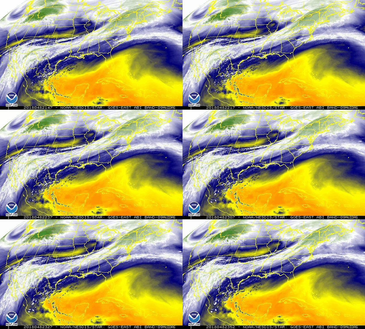
Here is the current water vapor tracing across the CONUS...note the atmospheric stream from the tropical Pacific aimed at the northeast...
OK...enough. But I would like to thank all of you who do read this and I truly appreciate your many observations, comments, questions, etc...As y'all know, I will always peruse the weather and its effects across not only PA but all of the country and even to some extent worldwide. But I also like to from time to time share this with y'all and am happy that many of you enjoy it. And I know some enjoy my musical selections as well; I hope you like this mellow one. Listen to the lyrics in line one...thus my choice for today. (I guess Paul didn't like winter?)
Happy Sunday!
Smitty
AA: A wet time of it the next couple of weeks. You'd swamp your mowers if you were mowing!
Since Tuesday, all of the modeling has been fairly consistent with this island of cold (and snow) in an otherwise sea of mild weather we are currently experiencing. It just so happens that a rather vigorous jet that will ultimately usher in our record warmth for the Tuesday-Wednesday time frame will also have a precursor runaway streak that will produce a moderate snow event here in southern PA during Saturday evening. Now I am aware that many have argued that the recent warmth will inhibit snow accumulations; however, what I am seeing is a rather quick moving heavy hitter of ++snowfall rates during prime-time Saturday evening...and that is my concern for my loyal readers. As many of you know, I'll likely be asleep when the heaviest snows are falling, but I know many will want to be out and about...just sayin' to be alert. I'll let some maps do more talking...
I'll start with the regional model for snow accumulations; usually the best predictor at this time range IMHO. The NAM is indicating a Route 30 special and has been for many runs in a row. KMDT will likely measure and inch either side of 4"...
Why such a robust quick hitter of snow? Glad you asked! The graphic below shows the energy in the mid-levels of the atmosphere this evening. Hone in on the focused energy from WVA through southern PA. The area near that concentrated upward motion will produce the heaviest axis of snowfall and more importantly snowfall rates. With that said, again the global models have been fairly consistent in recent runs with that mid-level vorticity and therefore a moderate accumulating snow is likely is these parts. Take a gander....
But that same jet will buckle even more in a SW to NE fashion in response to the vortex in northern O Canada moving west and sending arctic chill into the Rockies and northern plains. Here is the forecasted position of our upcoming mid-week jet...
A very large and anomalous area of Bermuda high pressure is flexing its muscle at all levels of the atmosphere...
This will produce a large area of much above normal temps for both Tuesday...
...and Wednesday while the cold is relegated to the western US. Record warmth is likely from our area north and east through New England both Tuesday and Wednesday.
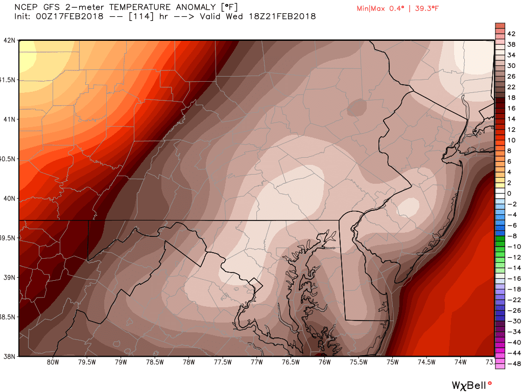
In fact, here is a close-up of our region's temperature anomalies for Wednesday. The graphic indicates our area to have nearly a 40ºF above normal max for the day! Normal maxes are 42ºF both Tuesday and Wednesday. Record maxes are 72ºF (1930) and 71ºF (1997) for Tuesday and Wednesday respectively. I believe this just may activate a Vitamin D watch in these parts; at the very least, a Spring Fever Warning to be sure!
So I will leave it at that. I do not want to rain on anyone's parade and show you the long term model run for temps for March! Did I even say that? Different story for a different day...But here is a nice little ditty with "spring" and "summer" hidden in the lyrics. Take a listen!
Alright, some unique weather events for everyone within the next 5 days...so enjoy nature's weather offerings and enjoy your President's Day week's end!
Smitty
AA: Saturday evening snow followed by a solid warm-up culminating (ending) with record warmth both Tuesday and Wednesday I do believe. Plenty of water in the soil now for the grass to quickly awaken come spring. Many crocus bulbs should be popping this week!
Very short post...I'm not believing what I'm seeing...Euro by Sunday morning...
Often the global models correct further north and west...I'm hoping waaaaay N and W! For those of you wondering and asking...well here is the GFS...
Clearly the Euro has a tad stronger wave of low pressure bending the arctic front that WILL push through Friday night-Saturday...big ?? is will that stronger Euro wave develop? I'm hoping not, but I've seen this many times before....and as for the longer term...winter is NOT over...as I now believe the beginning to middle of March looks rather wintry...ouch!
OK...enough from Fat Tuesday's synopsis...I've been studying music much more than the weather this evening, but when I saw that Euro output, I felt compelled to share....and I'll share my favorite tune I jammed to this evening...I hope you like as much as I like...by the way, 9 straight days of accumulating snows in sweet home Chicago! Tied a record from 2009 and 1902 I believe...awesome!
Out...
Smitty
AA: Thought we were out of the woods....? Not so sure now...? Great jam...worth listening to and your kids will be dancing by the end!