Saturday, March 16, 2019

It Is Now Officially Spring

In my book, it is now officially spring!  And for many reasons; some theoretical and others empirical.  The most obvious experience was the slow moving cold front that managed to pop a thundershower in our region Friday afternoon!  With temps in the mid 70s and a strong southwesterly jet about 1 mile up, enough lift was generated in the relatively dry air to manage a nice little spring surprise.  Couple that with the bomb cyclone producing record low pressures over Kansas earlier this week and the spring blizzard across the northern plains, it's clearly evident we are in a transitional season.  Frankly, now that sunset is approaching 7:30 pm local time, how can anyone deny spring has sprung?  Many have asked if we are done with winter and snow...and I believe we have a reminder skiff coming, (after all, it is still March)...but winter's spine has been broken for 2018-19.  Please allow me to expound...

First piece of evidence, our little "surprise" thundershower.  It was enough to upset our 11 year old girl who within the year has become the best barometer in the house.  Zola, our border collie mutt, has recently realized she has the innate ability to detect rapid atmospheric changes and tends to become highly agitated.  Friday evening was a prime example as a few small convective cells popped in our neighborhood.  Here is a still shot of the radar...note the snow back over Lake Michigan...a sign of the cold advection on NW flow for the weekend.
In addition, all time record low pressures were set (preliminary data only; not yet confirmed) in both Colorado and Kansas.  The lowest pressure officially recorded to date was 968 mb in SW Kansas...this is nearly as strong as a Category 2 hurricane...3 mb shy!  The satellite presentation was spectacular...the real spin occurs at the end of the loop.  Look at the "atmospheric river" coming off the Pacific Ocean feeding the water vapor into this monster.  Simply awesome meteorology!

Here is a 1 minute video link of various views, notably more visible imagery!

Of course, we were on the warm side of this magnificent atmospheric mammoth!  That brought our warmth for both Thursday and Friday...below was Friday afternoon and its glorious warmth!

But lurking to the north and west is winter.  I shared the graphic below with a colleague earlier this week and the response was "that's crazy!".  It's been a cold winter in the Great Lakes and northern plains and with the deep snowpack along with the extensive ice over the lakes, any NW flow at low levels will try to inhibit warming in the Ohio Valley and points east.  At least we have the Appalachians to help orographically downslope the air and bring at least a few degrees of warming south and east of the mountains.  From the looks of the ice compared to the "norms", I believe we need a New Green Deal!  Lots of ice on the Great Lakes when compared to the 30 year average...

And speaking of averages, this upcoming 3rd week of March will be below the 30 year average.  Here's a graphic for the PA averages from my favorite meteorological television offering...

...and it appears we will likely fall short of those temps most of the upcoming week.  Take a look...that's a 5 day anomaly of ~10ºF below norms for this weekend into later next week as per the Euro; my go to model as its skill score continues to out dual the GFS!

However, the following week appears to warm into spring and the longer range modeling suggests a warm April might just be in the cards, but that is a different story for a different day!  Here's the Euro's take for next weekend into the last week of March 2019.  By the way, that is NOT a severe weather signature for the south...good news for them!
And for what it is worth, here is that potential "skiff" I alluded to earlier.  Some just might call it the "onion snow".  For me, simply a reminder that the upper atmosphere is still quite cold, but that the March sun is getting stronger and stronger to warm the lower levels as observed yesterday! 
So come 5:58 pm EDT on Wednesday, the sun will be our side of the equator and continue to head north until 11:54 am EDT June 21, 2019.  I bet being at the location shown below would be a wild time...don't cha think? 
If it's still standing?

Sorry...I digress!  OK...I've rambled long enough.  The song Smitty; get to the song!  Well, I mentioned thunder earlier and one of my favs that mentions thunder is from who my wife affectionately refers to me as "my girl".  I hope you enjoy this Fleetwood Mac classic as much as I...
Happy Week's end (and Saint Patrick's Day for those of you so inclined)!

Smitty

AA:  Nature of convection; rain south and sun north of your location!  We had a faint rainbow upon shower's passing.  Back to normal and below this upcoming week and mainly DRY!  Time for the yardmaster to get his mowing equipment ready for the soon to be upon us mowing season!  MLB season, along with spring starts this Wednesday! 


Thursday, February 28, 2019

Marching In Like A Lion

Just a very quick post this evening to update this 1st part of March.  Good news/bad news...Good news is once past the Ides of March, things should definitely improve in terms of the weather, albeit still a tad on the coolish side...no record warmth that I'm seeing.  Bad news...we've got to endure winter's final fury until things tend to settle down a bit...

First off...another quick hit of snow during the overnight into early morning that will make the Friday morning commute somewhat of an adventure I do believe...the Euro has been most consistent and the GFS just got bullish as well on the snow in the KMDT region...the graphic below is about as textbook of a turnpike snow that I've ever seen!
And temps will be stubborn to rise tomorrow, but the higher March sun angle will help in spite of the cloud cover...Saturday will also have some light precip, frozen style, but the bigger ticket is Sunday night into Monday.  Here is where the models have wavered back/forth, but the axis of heaviest snows looks to go directly through our region once again.  The trend for the Euro, seen below, has been to slowly shift the axis south...while the GFS is moving it north.  This has the POTENTIAL to be our biggest snowfall of the winter season.  Still much uncertainty, but the global models have begun to hone into a PA special...the graphic below does not include tonight's 2-3" skiff...
I will just mention...but no graphics...another coastal is modeled for next weekend!  But I will show this; the temp anomalies for next week at 850 mb (one mile up for better representation of air mass movement)...Brrrrr!  Barney purple cold!  Bright side? The means are slowly rising...and the days (daylight) are getting longer!
OK...enough...I said quick update.  Just get to the tune...In spite of the Harper signing today, I'm ready for spring and the crack of the bat.  Maybe one these March blogs will someday come from sunny Sarasota or Clearwater...or BOTH!  Enjoy...

I'm out...

Smitty

AA:  Cold and stormy for the 1st 2 weeks of March; then a break I do believe.  I'm not a fan of the Harper signing by Philadelphia.

PS:  Check your home barometers if you have one next week...just wonder how that 1050+ mb holds together as it advects SE towards the CONUS and PA.  That's the true "Arctic Slide"...


Tuesday, February 19, 2019

Fabulous February

Climatologically, February tends to be KMDT's snowiest month with many numerous 3"+ type storms.  The true blockbusters tend to come until mid-March and it is of my belief that our end game of winter will not disappoint those wanting winter to wear onward and upward.  It certainly will be a major winter event Wednesday into the evening followed by a brief and MILD respite until the energy reloads for next week.  The first week of March also looks dicey as well, but that will be a different story for a different day.  Let's start with Wednesday...
The graphic above is a high resolution of the various types of precip and the total amount of each.  Note the minimal green (rain) around KMDT compared to the snow (blue) and freezing rain (pink).  My gut feeling is that the upper air will be dynamically cooled sufficiently to keep this event more snow than ice.  And the snow will start in a light fashion, but buckle up!  Within and hour or so, if the numerical guidance is correct, the mid levels will support some serious precip rates of 1-2" snows per hour.  With temps in the low-mid 20s, even with a Feb 20 sun angle, driving conditions will deteriorate very quickly in these parts and...well...you can see the issue!  This will occur for the bulk of the day until late in the afternoon when sleet mixes briefly before transferring to light freezing rain and drizzle.  This is when the ice will accumulate and potentially do so to our greatest accretion this winter.  More snow; less ice accretion...and vice versa.  Below I'm showing the 15:1 because I believe that at rapid rates of snowfall I'm of the belief will be occurring along with the slower onset of sleet, this is more likely to be closer to the totals...lesser accumulations result from quicker sleet and/or slower snows...
Many of you have heard me say, predict the high...predict the snow.  This is high pressure!  That's 1042 mb just NE of the Endless Mountains!  What's that Smitty?  Darn cold and dry air...a perfect set up for overrunning precip here in PA (if you like snow/ice/wintry weather).
And the mid-level juice is amped to say the least...green is very wet!  That's my rationale for heavy quick accumulating snows...quite heavy rains in TN as I type moving directly towards PA...

And just  for a little teaser for next week for those of you interested...a 2 day total of snow with a true MillerA nor'easter centered on next Wednesday...waaaaaay toooooo far away to predict, but interesting to share I do believe...
I thank all of you who have asked my opinion the last few days.  "Impactful" was my most used descriptor, and Wednesday's major winter storm might be our most impactful yet to date.  Will it be our most impactful of 2018-19?  To be determined...

I'm out...enjoy the tune!  For mi amigo from Lanco...just don't think it will be "softly" for much of the event!


Smitty

AA:  Snow starts 1 hour either side of sunrise and from 10-3 pm becomes very heavy!  1-2"/hour ending as a brief period of sleet then light freezing rain and drizzle to glaze winter's freshly fallen blanket.  Might? tickle 60°F Sunday prior to a true nor'easter next Tuesday-Wednesday...?  SD Padres World Series odds cut in half with recent signing!

Saturday, February 9, 2019

Wintry Week Warning

After a week long lull of the onslaught of winter cold and wintry precipitation, it appears to me that another extended period of winter weather will be with us through February and possibly into March.  It will commence early this week with a weak clipper disturbance followed by 2 stronger systems that will run a storm up into the Great Lakes with a second weaker low pressure forming along the east coast, both attacking a big arctic high...never a good outcome for those not wanting wintry precipitation!  And this active storm track looks to be in play at least through this month and I believe into March.  Allow me to explain...

First, a digression.  I mentioned the Great Lakes.  I always like to look at how frozen they are at this time of year.  As you can see, even with this past week's thaw, the total ice coverage is well above the 30 year mean (1980-2010).  I have a feeling the ice coverage will be above normal until "ice-out" later this spring! 
Closer to home, the weak "clipper" which is essentially a minor jet stream disturbance that will make the Monday morning commute a real "pleasure"...I'm showing you a map that indicates a saturated atmosphere up 2 miles...this is usually a good indication of precipitation occurring and though some will evaporate as it makes it to the surface, a wide area across the southern half of PA should end up with 1-2" snowfall especially with the high ratio snowflakes. It will be plenty cold for snow...

Then Monday night into Tuesday, a much stronger system will drive towards the lakes and bring a vast amount of moisture towards the northeast.  The initial onslaught will be snow, but I fear a prolonged period of sleet and freezing rain Tuesday with temps very hard pressed to get to freezing by day's end...the numerical guidance is also suggesting the same!  By late Tuesday, the Euro has a moderate snowfall accumulation and a major ice storm accumulation across central PA. 
These situations are always tricky to pinpoint, but I'm thinking snow to brief sleet, but then freezing rain as the arctic high will cold air dam the surface at or below freezing for most of the day Tuesday.  Note the 1040 mb high posted across Quebec...bonjour!
Then next weekend, the parade of storms continues...
And why do I believe we are continuing this into March?  It has to do with the MJO phase.  Madden-Julian Oscillation is the lesser known of the major ocean oscillations.  Most have heard of El Nino/La Nina...or ENSO.  Essentially, the science is that the pressure and precip patterns in the tropical Pacific and Indian oceans have a major influence as to how the large scale Rossby waves (jet streams) react and position themselves.  So as to not bore you any further, just 2 final graphics...here is the Euro's seasonal MJO prediction over the next month.  You'll have to trust me when I tell y'all that most of the other numerical guidance is indicating similar movement into phases 8-1-2...What the heck am I looking at Smitty?  Start at the green line where the yellow is most concentrated (phase 6) and notice how it quickly moves through 7 into 8 and the strongly into 1.  The inner circle is where there is minimal affect.  As you move outward from the center, the atmospheric effects are more significant. 
And below is the effect on temperature here in the USA during the JFM time frame...we were just in 6 and 7, the warm phases, but are now heading towards the colder phases of 8-1-2.  We just wait and see how all of this plays out?  I do find it rather intriguing to say the least!
Hey...Blame it on El Nino!  Enjoy!

Happy weekend!

Smitty

AA:  Another wintry week this week with likely disruption of schedules.  The song is kinda funny!

Saturday, February 2, 2019

Groundhogs Galore

Well, February 2 is here and this marks celebrations all across Dutch settled regions of Marmota monax, commonly referred to as the groundhog.  Whether it's the prognostication from the gold standard Punxsutawney Phil or the lesser knowns of Octoraro Orphie and the very little know Etters Eddie, on this cross-quarter day astronomically, people will want to know if these mammals have seen their shadows.  And though long range weather forecasting can be a challenge, Phil doesn't do a bad job!  He certainly does have a bias towards more winter...and rightly so as we still have February and early March to get through.  Heck, last year we here in PA experienced winter type weather right into April!  Here is a graphic showing Phil's predictions since 1887...
Phil did see his shadow last year and was correct with his call.  Try to recall the FOUR nor'easters of last March!  The other notable "bingo-front row" forecasts of recent times were 2014 and 2010 where February in these parts were quite snowy!  Below is a time-lapse of last year's barrage of storms to hit the eastern US...it's worth the 50 seconds...
So with the recent snow and cold entrenched in our memories, will Phil call for more winter?  Or will he check out the numerical guidance that suggests winter is over, at least for this upcoming week?  If he looks at the Euro's guidance for the 1st week of February, this is what he will see...
But that 2nd week of February is indicating a classic battleground setting up in the eastern US which could create another cold and stormy pattern in these parts.  Look at the warmth across the SE US compared to the strengthening cold across the rest of the continent.  Usually, the cold wins these battles at this time of year.
And simply for kicks and giggles, here is the Euro's guidance for both temperatures and snowfall into the middle of March.  If Phil sees this, he'll quickly see his shadow and regroup in his burrow for another 6 weeks!  First the temps...the entire US below norms with the lone exception of Florida!  That's suggesting winter is taking a brief respite this week before reloading...
...and this graphic below suggests a stormy time of it here in the eastern US.  February is often a snowy time in these parts...and this numerical model guidance is indicating snow all the way to the Gulf coast in TX and LA!  Heck, if that is even remotely close to being modeled accurately, Phil will have a difficult task clearing snow from his home in Punxsutawney! 

As for today's astronomical celebration, the sun has progressed to about its 1/2 way point from the noon sun angle being over the Tropic of Capricorn to the noon sun angle being over the equator!  Our 9 hours of daylight have lengthened into about 10.5 hours and soon on the Vernal Equinox, our noon time sun angle will be a much warmer 50º as opposed to a very ineffective and dark 26º.  So that is indeed something to celebrate!

Enjoy this Groundhog Day blues tune from Johnny Lang and Double Trouble! 

Happy Groundhogs' Day!

Smitty

AA:  After winter loosens its grip this upcoming week, it appears that we are back to a cold and stormy pattern to close out winter...at least that what the numerical models are indicating.

Wednesday, January 30, 2019

Snow Squall

FYI...around noon today...a strong squall line will be advancing through our region and is likely to create a quick accumulation of snow in white-out conditions!  We living in the Harrisburg region are not to accustomed to such winter events; just be aware.  This is the arrival of the truest of arctic air!  Temps will drop this afternoon and winds will be gusty creating windchills 10-15 below 0.  Just wanted y'all to know...if you didn't already!
Smitty

Tuesday, January 29, 2019

Big Snows

As I was departing my place of employment today, a co-worker (and loyal reader I might add...) so eloquently asked "well Smitty, are we ever gonna get a real storm this winter?"  Frankly, I forget my quick and not so thoughtful response...sorry...but it got me thinking that many of us think, living here in the sub-tropics of North America, that we should get major snow storms each and every year.  As a getting there "old-head", I've had my share!  You youngins...you had more than you should!  The true old timers are where the snowstorms regress to the mean...please let me explain.

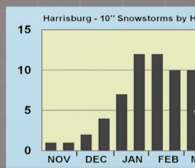
The graphics that I'm using for the most part come from the heavy lifting of Dr Jon Nese of PSU; he recently did a segment on my favorite TV show "Weather World" about 10"+ snowfalls in PA!  The statistical breakdown was 2nd to none.  I will paraphrase his emphasis...

First, the number of 10"+ storms at his chosen 5 stations in PA since the late 1896...
...and then divided down to each decade period...(10 years y'all, I guess I'm still in the classroom!)
So basically every other year we should get a good one in these parts.  My loyal reader, likely more often since my loyal reader is skewed NW of KMDT towards KUNV but the names will be confidential so as to not admit as being identified as a "loyal reader"...!

As for KMDT...which I believe has a low bias snow measurement as does KDCA in Washington DC, we still have the first part of February before the frequency of such snow bombs begin to decline, albeit minimally...


The graphic below I found interesting as this was KMDT's snowiest winter on record...one of the only FIVE times...yes...FIVE times when these FIVE sites had 10"+ storms all from the same storm!

Of course the grand-daddy of east coast nor'easters...The superstorm of 1993...
I wasn't alive for the 1961 blast, but I'm sure most of y'all recall 1993!  It occurred on a Saturday into Sunday(thundersnow, too!) and we got back to school Thursday...it was a doooooozy!

Just an offshoot...KMDT's biggest snow is not even a big deal in the 4 other locations so much...take a look!  And y'all enjoyed that storm to be sure...(I did beat IV on the O/U for once!)
For those of you keeping records...here is the NorthEast Impact Snowstorm Scale broken down by years...please feel my pain; I lived the weather from the 70s through today; had a few fun ones lately and back in the Clinton years, but we all live here in the Sub-Tropics as I am so insistent!

OK...I've rattled long enough; some of 8th period is probably glad that they didn't have to hear my discourse, but for those of you who read and appreciate, a genuine "Thank You"...and one to Dr Jon Nese for the graphics and heavy statistical lifting...and one to my loyal reader who shall remain anonymous living halfway up 322 towards PSU!  Maybe not so much anymore...

OK, I'm out; big flakes with the wave spinning up the front currently over my place!  Looks like January outside to be sure; will feel like it the rest of this week!

Enjoy my song choice...and if any of you who listen to the songs have ideas associated with the weather, please let me know!  I'd really like that...

I do like Mumford and Sons...


Smitty

AA:  A nice snow event this afternoon into the evening, then the arctic emperor invades!  Check out these wind chills Thursday am... Brrrrrrrr!  Bundle up yourself and those darlings of yours!