Wednesday, September 4, 2013

ACE (s) Not Wild

Here were are as we enjoy absolutely spectacular September weather, the question was once again asked of me "Smitty, where are all the hurricanes?"  Obviously, my circle of friends are well educated knowing that as we enter deeper into the month of September, hurricanes in the Atlantic basin are usually commonplace.  In fact, here are some climatological statistics for tropical storms and hurricanes for the Atlantic basin using the 30 year period from 1981-2010:

Named Storms per year:  12.1

Becoming Hurricanes:  6.4

Becoming CAT 3 or greater:  2.7

Here is the current wide angle view of the Atlantic via IR satellite imagery:


There are 2 areas of disturbed wx, the broad circulation just to the NW of the Yucatan Peninsula and the double barreled low over the Leeward Islands.  In fact, if the atmospheric energy could work in cahoots as opposed to stealing each other's thunder, a named system would likely develop just to the north of PR.  As of this writing, that does NOT look likely.

So what is this title about...ACE?  A relatively recent manner in determining how active a tropical season was or was not is not by simply looking at how many storms formed, but to apply a quantitative measure based on wind energy created by these tropical cyclones.  The acronym ACE represents "Accumulated Cyclone Energy".  For those of you who are truly interested or are like me and really don't have a life outside of weather and some good music, the ACE index is derived by summing the squares of the max sustained wind speed (knots) measured every 6 hours for each and every named storm while they are at AT LEAST tropical storm strength.  Here is the ACE Index as viewed climatologically for both hemispheres...clearly September is the high ACE month in the NH!


So where do we stand today?  In the Atlantic basin, we are obviously WELL BELOW NORMAL!  Our normal ACE Index at this point is 39...we are presently sitting at 8.3!  All of August and nearly 15% of September are gone!  The Atlantic better start kickin' to get even close to normal...here is the ACE as compared to the last 11 years...2013 is the black line running across the bottom.  The vertical blue line is today.
By the way, here are the numbers of tornadoes reported YTD...again, 2013 is the black line that is well below the other lines indicating a severe season with many fewer tornadoes as compared to recent years gone by.
And the prospects of a flourish of hurricanes is not really in the cards of many of the global models.  Here is the Euro showing some signs of life 7 days hence...

With all of that said, I'll leave you with a different kind of ACE...enjoy!

And enjoy the end of your work week...

Smitty

AA:  It's been a below normal season for tropical storms to date when using the ACE index.  But ask any of the land barons along the east and Gulf coasts; they are all quite fine with this lack of activity!

Tuesday, September 3, 2013

An August Review

As we now proceed deeper into the month of what is often some spectacular wx for the year, it is always good to look back at what we just endured...and that is August 2013. And remarkably, August had NO DAYS...NONE, where the max temp reached 90F!  In fact, on only 3 occasions did the mercury top out at 87F; the 27th, 30th, and 31st.  The lowest temp for the month was 53F on the 15th of the month.  Here is a climatogram of temps for KMDT.
I believe it is plainly evident that the bulk of the temp bars spent most of their time at or below normals with the notable exception of the past week.  In fact, while perusing the entire year, again, with the 2 exception2 of late Jan and early April, cool was the rule for most of 2013 in KMDT to this point.
As for precip, KMDT is running a few inches below the 30 year average to date.  Here is a quick graphic showing the accumulated precip for the calendar year to this point. It seems strange that we are running a deficit of rainfall, but the numbers don't lie!  KMDT had 14 days of measurable rainfall in August, but only 2 of the days had in excess of 0.50" of rain, the heaviest falling on the 28th where the airport received 0.92".  It's just that the torrid heat that often persists for spells over our summers just wasn't present this past August.
There was a very unique precipitation event not too far to our east however at the end of July in the City of Brotherly Love.  Look at the 8.02" at the end of July and the spike of accumulated precip that will not allow Philly to run a precip deficit this year!  A narrow band of intense thunderstorms trained right over the airport and voila, and incredible event is now forever recorded in the books at KPHL! Two and a half month's worth of rainfall in about 2 hours!  Unreal!
So while Philly is running a huge surplus, we are running a 3" annual shortfall in precip!  Clearly, though, the temps were more in line with KMDT as Philly also had a cool August.  In fact, both KPHL and KMDT ran ~1.5F below the 30 year average for the month of August. Had it not been for the anomalous heat the last week of August, a much larger deficit would've been achieved for August. I'm not sure why I don't see the GW crowd touting that fact?!?

So what does September hold in store?  The CFS v2 suggests a warm west especially up into O Canada, and cooler east, again especially up in the province of Quebec. In these parts, we should see a progressive pattern meaning swings in temps from below norms at times to above norms.  Statistically, it should all balance out to very much near the 30 year average by month's end...
And speaking of August, I'll leave you with what I believe might be the most famous cut off of Eric Clapton's 10th studio album released in 1986 titled August.  He and Phil Collins collaborated to produce this number one hit that many will recognize as being in the Tom Cruise-Paul Newman film, The Color of Money.  Enjoy this "August Flashback"...and enjoy your mid-week spell of spectacular wx!


Smitty

AA:  August was cooler than normal and believe it or not slightly drier than normal! And August was a good LP released in the mid 80s by one of my favs, EC!

Monday, September 2, 2013

Enter Autumn Stage NW

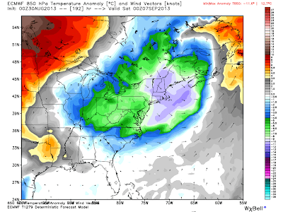
A bona fide cold front will pass through within 24 hrs of this posting...and from this seat, a welcomed change to the current month in which we now reside.  Here is the 850 mb temps as forecasted by the Euro for tomorrow am...
And a secondary shot of autumn to be felt in these parts later in the week...say about Friday...
But later in the medium range, the heat from the southern plains is threatening to return...here, the Euro shows a broad SW flow advecting heat and humidity towards PA.  In addition, if there are any tropical troubles, and there very well may be, this pattern allows for a tropical system to move along the Appalachians up towards these parts beginning any time from this weekend on...

Here is the NAM tropical wind swath suggesting the potential for a storm to be moving towards FL by late in the weekend...I don't really but this solution, however...
O Canada keeps this potential well off to the N and E of the CONUS...albeit, a formidable storm nonetheless...
So on this Labor Day, 2013, the final day of summer as viewed from an historic point of view, we enjoyed late season heat and humidity.  However, as we progress deeper into September, most notably this week, cooler and much drier wx will become the served up on the wx menu.  With that said, let me leave you with one of my favs off an album released in 1970 with an appropriate title for today...

...and here is that tune...from a live version album (Europe '72).


Enjoy your Tuesday and the beginning of your WORK WEEK...for most of you reading this...

Smitty

AA:  Cooler and drier this week.  Warmer air returns next week.  Still watching the tropics and listening to good tunes.

Friday, August 30, 2013

Double Shot of Cool

Just a very brief update as to what now appears to be an initial and then a reinforcing and stronger shot of cool and dry air beginning later Labor Day and temps then moderating by the weekend.  First here are the temps a mile up as progged by the ECMWF starting WED afternoon...
...Now THURS pm...
FRIDAY pm...(Will NOT be a fry-day)

And lastly SATURDAY pm...
Keep in mind that the scale on these maps are in Celsius; so about doubling the number on the scale is a rough idea for degrees F.

It appears the weather gods are in tune to this being the last "official" weekend of summer....so enjoy!

Smitty

AA:  Becoming much more autumnal next week.  Or more like football season...

Thursday, August 29, 2013

Where are the Hurricanes?

That was a question a former colleague posed to me today electronically.  Not that this gentleman who lives in a flood plain is looking forward to another bout of heavy wind and flooding rains...I just believe he was genuinely curious as to the whereabouts of the tropical menaces that appear this time of year.  Climatologically, he is spot on as the graphic below indicates...
From mid-August to mid-October, one is likely to see several tropical storms and hurricanes during this period in our Atlantic basin.  However, even though the hurricane center is presently monitoring 2 areas that are likely to be named, there has been a major factor to inhibit convection in the tropics and that is Saharan dust being whipped high into the atmosphere to replace mid and high level humidity and thus dampen the likelihood of tropical development.  Look at this satellite pic showing just this very thing...

Yet, in spite of this, there is potential in the tropics as seen from this water vapor sat pic...note the central Atlantic and the area of deep moisture with a minor circulation...

In addition, take a gander at the storm complexes just moving west from the African continent.  These too have potential as the pattern is beginning to favor tropical development.
Meanwhile, back home where it certainly feels tropical, it will not next week.  Take at look at the temps over the next 5 days for the period ending Labor Day...
...but then look at the next 5 days for the period ending next Sunday!
In fact, just in case you're curious, here is what the CFS v2 suggests for all of September...near to ever so slightly below normal here in PA.
With all of this talk about the tropics and hurricanes, I once again am reminded about our recent trip to bayou country.  It's one thing to read about; it's really wild to drive on I-10 for dozens of miles at a time on raised "causeway" type interstates just to stay out of the water.  It is really quite different!  So it's no wonder to me that these folks who lead a tough life found time to live life and have a grand 'ol time since they were "Born on the Bayou"...one of my favs from CCR...and I hope you enjoy as well.


Enjoy your Friday Night Lights...and enjoy your week's end!

Smitty

AA:  Looking for tropical troubles; a few might be brewing sooner rather than later.  Much cooler and drier next week!


Wednesday, August 28, 2013

Book-Ended By Heavy Rain

As I mentioned yesterday, much of today would feature rainfall across much of PA, but mostly to our west and to our east.  In fact, flooding rains fell at very intense rates earlier today out in the Laurel Highlands where several Flash Flood Warnings were issued.  Below is a graphic showing the rainfall observed over the last 12 hrs...Also note the total lack of rain where the center of highest pressure was located from yesterday's 500 mb map; OK, KS, AR, MO!


As for the upcoming pattern, there is some disagreement as to how much cooling will occur thanks to our friends from the north. The Euro is a tad more bullish on a rather potent air mass change for next week while our lovely GFS isn't quite so sure...here is the Euro's temps for the next 4 days...1st the operational run...

...and now the next 4 days as smoothed out by the Euro ensembles...rather good agreement!
Now, here is the Euro for later next week...in the 6-10 day period...again 1st the operational run...
...and now once again the Euro ensembles...not quite as good of agreement on the later period, but nonetheless, an notable air mass change.
Meanwhile, the Euro's 500 mb anomaly is very suggestive of much cooler air in the eastern third of North America!
However, the GFS for the same time frame is not signaling as strong of a 500 mb trough...it's a bit flatter and slightly more progressive.  Both do still have a ridge out over the high plains later next week with the Euro being more amplified.

So what does all of this indicate.  After what will prove to be an unsettled weekend with Sunday and Monday the most likely days to see thunderstorms in these parts, I do believe a substantial air mass change will occur next week bringing with it, somewhat cooler but noticeably drier air for the middle and latter parts of next week!

Driving home today, I was listening to our president's address in honor of MLK's famous Aug 28, 1963 "I Have a Dream" speech...so I'll leave you with the familiar Billboard top hit of that time that remained in first place for 4 weeks...sung by The Angels....
Enjoy your end of the week...

Smitty

AA:  Unsettled warm and humid weekend with Sunday and Monday the most likely days for storms.  PSU to cover the 8 at Met-Life over The Orange.  Slightly cooler but drier middle of next week!

Tuesday, August 27, 2013

A Wary Eye West

I know; it's been awhile.  But this potential late summer "severe" weather event pushed me to pen...or keyboard! What event might you ask?  The pattern has been very calm!  Indeed it has been and we've been experiencing rather benign wx of late. However, as a huge late summer heat ridge has built over the Midwest, PA is on the eastern periphery of this heat and parts of PA have been in/out of some rather heavy rains and strong thunderstorms.  Tomorrow (Wed), I believe somewhere from I-81 west to the I-79 corridor will receive copious amounts of rain that will likely lead to flash flooding since most of that terrain is rather mountainous.

Here's the set-up...first the heat to help supply the necessary energy...
And the present upper air indicating the huge heat at the 500 mb level...note the large high pressure over KA, MO, AR, OK!


Well, the numerical modeling is bullish on developing a cluster of thunderstorms that will traverse western and central PA overnight tonight into later Wednesday evening.  Just where the heaviest rain does fall is the million dollar question?!?  The strongest upward motion will be over western and central PA Wed pm...note the "swirl" that is evident right over central PA.  These dynamics will act to squeeze the humidity right out of the air and rainfall should be widespread and heavy!
The humidity is in place as most of you know by feeling it and as seen by these dew points...
The global Canadian and the Euro and in fairly good agreement here in the short range delivering the worst of the rains to western PA and the panhandle of MD.  However, just be wary that a slight shift east of where this axis sets up will cause heavy rainfall in the KMDT midday Wednesday on into the evening. Here is O' Canada and her solution to this interesting synoptic set-up...just a snapshot for Wednesday midday...
So an axis from Detroit to the southern Delmarva will be where the heaviest rain should fall...here is the Euro meteogram for IUP...(with convection, places just a few miles apart can observe vastly different amounts of rainfall; just where does that axis of heaviest rain develop?)
This system will then continue to dive SE and "bomb" once it gets to the tropical waters off the VA tidewater.  We here in the KMDT area will be treated to lowering humidity and more comfortable temps again on the back side of this digging wave for Thursday and Friday before another surge of heat and humidity try to move east from the impressive late season heat wave in the Midwest.  By Friday morning, the Euro has quite a system from this synoptic set-up!


So, with that, I opined about the potential for some very heavy rainfall that might just make in-roads here to KMDT, but should stay just to our SW and then S and then off to our E.  That's not saying we don't get any rainfall, but the heaviest should be out in the Laurels tomorrow.

Several have asked why I haven't "blogged" for the last half year and the reasons are many...but I may just start up again.  So if you'd like, pass this on...or dump it in the digital trash. But as many of you know, just prior to the start of yet another glorious academic year, I ventured to several more MLB parks in the SE quadrant of these United States.  One of the stops along the way was "The Big Easy". No MLB, just some butt-kickin' blues.  In fact, I'll leave you with a song that I heard for TEN DAYS being sung from the rear of the vehicle when the crooner in question wasn't sleeping!  I hope you enjoy as much as I did!
And enjoy your "hump day; only 3 days until "Friday Night Lights"!

Smitty

AA:  Heavy rain probably just to our west Wednesday; slightly cooler and drier for Thursday and Friday!  Getting warmer and more humid for the weekend again.