Smitty's attempt to educate and to a much lesser extent, entertain, about all facets of life; but primarily the meteorological and the climatological aspects of the earth sciences.
That is if you believe the global modeling for next week! But first, how about that frozen precip this morning. I was over in Mechanicsburg early this am and it was coming down for a brief period; heavy wet snow and sleet! Many of the cars in the parking lot had evidence of a brief "downpour" of frozen glop from the passage of the cold front. The satellite pic below shows the front well offshore and the SE quadrant of PA under bright sunshine while the bulk of PA is under the StratoCu that so often accompanies the cold air aloft at this time of year...
And here are the 24 hour temp changes from yesterday afternoon! Nearly a 30F temp drop is impressive...don't cha think?
And high pressure will be large and in-charge for the remainder of the work week. Here is the Euro's take on the surface pressures for Saturday morning!
However, the wx begins to deteriorate as we progress through the weekend and into Thanksgiving week. Here is the Euro's solution for next Tuesday! Wow...yet another storm along the east coast! Again, this scenario does not bode well for the east coast beaches from the Delmarva northward. Literally, no rest for the weary! This is some strong winds that would be slamming big water into the unprotected beaches...not a pretty sight!
Then...2 days later...the storm blasts down east ME with big surf, heavy coastal rains and season starting snow pack interior snows! They would most certainly be using sled dogs to get to Gram-ma's house this Thanksgiving!
However, there is not consensus in the world of numerical global modeling! The GFS shows a much weaker solution waaay out to sea! The map below is for the time between the 2 Euro maps above. Large high pressure over the maritimes doesn't really suggest a storm heading out to sea. Again, I believe the Euro will win this debate and ultimately we will see yet another large nor'easter at some point during the Thanksgiving week!
Take a look at the blocking that is being suggested by the Euro. What that entails is high pressure aloft over the N. Atlantic which funnels cold air and into the eastern part of N. America along with a storm track that tends to move slowly up the coast. These anomalies are quite large and suggest the east coast must be monitored for yet another major coastal system! Huge trough in the east; large ridge in the west; and in the upper right corner, large ridge or "blocking"...something the Eagles offensive line should look into!
And a slightly wider view of the 500 mb pattern that suggests the interesting blocking pattern...
The GFS doesn't really have much of a system near the coast because its energy is all out of whack! Look at how disjointed this 500 mb vorticity looks. However, I do point out (orange arrow) this little feisty looking vort max that should be monitored for a surface system to spin up as a result of this energy. We will see what we will see...
OK...I've rambled enough! Even though not a huge fan, does anyone else miss the NHL? I kinda like sifting through the stations and stopping and watching a period of NHL in lieu of just about anything else the tele has to offer! I know it is football season and Thanksgiving and football go together like cranberry sauce and turkey, but just sayin'...I like the NHL and do miss it to a slight extent! Let's put it this way, I wouldn't mind at all if the NBA was locked out as opposed to the NHL! Winter means ice, snow and cold! By the way, here is a north polar view of the current snow and ice cover over the northern hemisphere! Note the recent snow cover from the blizzard that just pummeled the northern plains of MT and ND! And note the extensive snow cover over Asia and northern China! It's all about global warming as y'all know! Also note how the Gulf Stream keeps port Murmansk open in Russia! (See post here.)
OK...definitely going to go now. After all, its almost dinner and I need something other than the deluxe Carrot Cake I enjoyed today compliments of my friend Yokes. Although I might call it a victory cake, my friend and I both agree that I did win this cake as a result of an electorate who does not believe that freedom and personal responsibility is a "real big deal". However, as the eternal optimist, I do believe that the America I once knew will rebound and once again become the most respected nation on this planet. Whether it be from its political stability or its economic steadfastness, America will regain its status on the world stage...and with that, I will leave you with this folk classic...
I'll try to keep y'all posted on the pending weather for Thanksgiving week!
Enjoy your Wednesday!
Smitty
AA: Nice weather this week...deteriorating into early next week!
For the middle of November, the wx this week will most certainly cooperate. Once this rather sharp cold front passes through later this evening, the wx will be dominated by high pressure for the remainder of the week into this weekend. And this is quite the front...it doesn't have great upper level dynamics associated with it like it did out in the mid-west as it progressed across the CONUS; however, there will still be quite a bit of showery rains and gusty winds 12 hrs either side of the frontal passage through KMDT. Here is a snapshot of the temps on either side of the front as progged by the NAM...
Note the 24 hour temp change with the passage of the front in the mid-west!
The heaviest of the rain appears to want to fall early Tuesday morning and if you take the Rapid Refresh Model literally, the morning commute with be one with heavy showers to contend!
But once this cold fronts progresses through the east, high pressure will rule the roost. Look at the forecast modeled lows for Wednesday morning...quite a difference from this mild Monday morning!
Also note the uniformity of the morning low temps across most of the CONUS! Hence the term...air mass! Here is the GFS' take on the pressures at the surface for Saturday morning. Looks like a typical fall regime with clear cool nights and mornings with moderating temps during the day with relatively bright sunshine. do remember that we are essentially only ONE MONTH from the lowest sun angle we see at our latitude! So don't rely too heavily on the warming power of the sun at this time of year...although Ol' Sol can work his magic!
Eventually, that 1035 mb high will move NE away from the US and allow some unsettled wx to gather over the southern states that must be watched for Thanksgiving week. The Euro actually has yet another coastal storm progged for the early part of next week...and the pattern suggests this solution could verify. At the very least, it must certainly be monitored for devilish developments which could make the wx in these parts rather interesting a day or 2 either side of Turkey Day!
So there is a quick overview of the wx for the next week. Once the wx systems come more into line for next week, I'll try to update everyone with how the sensible wx might respond. In the meantime, more about the fiscal cliff, the losing Eagles, and the solar eclipse in Australia. Yes...keep your eyes on the internet to see some neat reports from the total solar eclipse over NE Australia and the Great Barrier Reef!
Or you can monitor how Congress and the newly re-elected president want to tackle this so called US Fiscal Clif...
Not to be confused with what my buddy saw me eating today, called it...my "Fiscal Clif Bar"...made me laugh! Maybe you had to be there, but I thought it to be very humorous!
OK...enough for now...so since I mentioned "Eclipse", I'll leave you with a cut from one of my favorite albums of all time...released in March of 1973 and sold over 15,000,000 copies in the US; Pink Floyd's Dark Side of the Moon. The final cut (not another one of their albums) is titled Eclipse...and I think you might like!
Enjoy....the mid-week, the cold frontal passage, and this incredible closing song!
Smitty
AA: Cold front passes through overnight Monday into early Tuesday with some rain and wind...then nice seasonable wx into the weekend. Watching a storm for Thanksgiving week....?
A very brief post: 1st the snowfall from the nor'easter...I know...none at KMDT! Just let me have it y'all!
Next...wall to wall sunshine Friday with high pressure ruling the roost!
Temps moderating and exceeding 60ºF both Saturday and Sunday! Could hit 70º either Sunday or more likely Monday!
But a strong cold front is poised to move through on Tuesday! I'd expect to even see a wicked thunderstorm accompany the frontal passage. Here you can clearly see the front out across the Ohio Valley as progged by the GFS 2 m temps...
And see it even more clearly with the deviations from normal. Look at the brutal cold over the northern plains! Montana is experiencing blizzard conditions today and into Friday! We will be ~+15ºF above norm while parts of eastern Montana will be -30ºF below normal Sunday afternoon!
But get ready to enjoy some nice November weather this weekend! Warm front pushed through overnight Sat and quite mild air on SW winds will complete the exacta for a nice Sat-Sun weather weekend!
Enjoy it.....
Smitty
AA: Nice wx this upcoming weekend. Little or no chance of precip through Monday with moderating temps as we might hit 70ºF either Sunday or Monday! Indian summer to be sure!
Don't look now, but the global modeling is coming into better consensus that during the late Tuesday to early Thursday time period, KMDT will be experiencing your typical cold season nor'easter. Unfortunately, the ravaged coastline thanks to Hurricane Sandy will also be experiencing rather severe wx conditions that would make any mid-latitude cyclone proud! 2-3' tidal flooding above the norm coupled with onshore winds of 35-50 mph spells true disaster for an already pummeled eastern seaboard with no buffer from the ocean's hostility as the beaches, berms and dunes have largely been eroded. This situation should not be taken lightly...let's hope that power is restored to many of the homes and businesses prior to the development of this upcoming wx event. Here is the Euro's evolution of the storm from Tuesday to Thursday...
TUESDAY EVENING
WEDNESDAY EVENING
THURSDAY EVENING
The map above is actually a rather interesting depiction of what shows a cold conveyor forming and central PA receiving some rather appreciable deformation zone snows...but it is waaay to early to forecast that. Just saying, this could be a sizable snow for many parts of central and northern PA north and eastward up through interior New England. To be sure the White Mountains of NH will be WHITE and the Green Mountains of VT...well...not so much GREEN, but WHITE as well...
Once the storm passes, a vigorous NW flow will usher in cold air into our part of the country. Look at the temp anomalies for the next 7 days...note the deeper blue in New England; evidence of an early season deep snow pack!
And snow is beginning to show in the northern hemisphere as seen by this north polar view of planet earth...
OK...so there is a brief synopsis...very brief...of the upcoming potential nor'easter that, if it develops as per the Euro, will wreak havoc over the battered coast and bring further hardships and heartache to an already fragile populous. Once these forecasts reach greater consensus of the impending storm, a sense of urgency should and must prevail in terms of restoring power for these areas. Otherwise, this storm will greatly compound the brokenheartedness already being experienced by a large segment of the greater NYC and NJ population. Let's not forget that this storm will also impact New England as well, a region that also had severe effects from Sandy, just not to the extremes as experienced further south closer to the land falling monster! Personally, as most of you know, I love a good storm! But this is too much of a good thing....waaaay too much. I wouldn't wish these weather woes on my worst enemies!
There was a fund raising relief effort shown on TV last evening my wife shared with me. She mentioned the performance of a few of her favorite musical artists and I will share this with y'all!
Now its off to handicap the Breeders Cup races for 2012 being held at beautiful Santa Anita where the forecast is for sunny skies and 80F for later today! A perfect day for taking in the "Sport of Kings" and enjoying the 2012 Horse Racing Championships!
Enjoy your week's end!
Smitty
AA: Watching for a potentially devastating nor'easter to hammer the already beaten and battered east coast with heavy surf, wind, and rain. Possibly/probably our 1st accumulating snow for the winter season of 2012-13! But as of now, I believe the bulk of the precip that falls at KMDT will be rain.
I have just a bit of time to simply put y'all on alert that all of the global modeling with the exception of the GFS suggests another slow moving cyclone will move up along the mid-Atlantic coast in the next Tuesday to Thursday time frame. The GFS also has a storm, but it is slightly further out to sea...This storm will be much more of a typical nor'easter, but any exceptional wind and waves along with the cold will be unwelcome wx guests along the battered coastlines of the Mid-Atlantic and northeast. I have not had much time to look into this, but snow is a real possibility even in the KMDT area, but as is so often the case, the exact path and strengthening of the storm will determine our precip type. This time of year suggests a cold rain; however, there is plenty of cold air available for an early season snow! Here is the Euro from overnight....Wow!
And the 500 mb height anomalies for next Wednesday...that is a deep and strengthening negatively tilted trough with a nice block to the northeast!
I will try to get something out tomorrow; more likely Sunday! This is Breeders Cup Weekend 2012!
Enjoy the week's end!
Smitty
AA: Watching a more typical nor'easter for the next Tuesday-Thursday time period.
I just wanted to show you what a dying superstorm looks like at various levels of the atmosphere. I apologize from the get-go since I downloaded these pics early this morning; however, I am now just to getting to place it into a reader friendly forum from yours truly. Again, our effects here in central PA were less severe than along the coast, and indeed, that is how it should be since tropical systems are more about surge and less about rain and wind. Inland, we had our share of both rain and gusty winds. However, the rain was manageable for the most part (although we received just over 5" for the storm total in about 48 hrs) and the wind's ferocity was mitigated by the fact that the "dead-wood" was already pruned from last year's heavy wet Halloween snow and the gusty winds that quickly blew through with Hurricane Irene.
With that said, here was the surface map for early this Wednesday morning. Note the spiraling "troughs" pinwheeling around the center of low pressure located over Lake Erie. These little vortices increase upward motion and promote a bit more enhanced precip if other favorable dynamics are present.
Now lets venture up to 850 mb or about 1 mile above the surface...it was chilly here in PA today and the map below shows why. The temps aloft were quite cold! Frankly, the temps were capable of supporting snowfall in most of PA! Also note the large cold conveyor on the west side of the low straight down from Hudson Bay!
It's also been quite cloudy...7 days in a row where KMDT reported 100% cloud cover! Wow! Look at the humidity 2 miles up at the 700 mb level....quite saturated!
At the 500 mb level, or about the point where half of the air is above that and the other half below (3.5 miles or so...), there is still quite a bit of spin or vorticity right over PA which helps promote rainfall, albeit light or at the very least enough upward motion to create widespread cloud cover...
Finally, the 250 mb level, or the level of the jet stream for our latitude. Note how far south of PA the jet stream is positioned thus allowing for the cold air to move southward over the continent! Also note the ridge or poleward bulge out over the western US and the equatorward dip here in the east. A general rule of thumb is when it is warm in the west, it is cold in the east and vice-versa...
Since we went up to about 30,000', lets take a look at what a dying superstorm look like from a geosynchronous orbiting satellite (~23,000 miles) using its infrared eye...
I've had several people ask why do these storms form? Well...that is a loaded question! But to keep things quite simple and ultimately the most concrete basis of fact, cyclones develop to move hot, humid air poleward and dry, cold air equatorward. These mid-latitude cyclones develop a large circulation that helps accomplish this feat. Look at this morning's temperature map...55F in Caribou Maine while it was 39F in Tallahassee, Florida. I believe the gyre did its job!
And to show you just how much "topsy-turvy" this system made the wx, look at the snow...FOR OCTOBER...over the Appalachian Mountains...incredible! Snow was reported in the highest elevations of GA!
Here are some 2 day totals reported from the state of West "by God smile when you say it" Virginia!
Don't want to add insult to injury, but look at what the GFS has up its sleeve for next week at this time....but that is a different story for a different day!
OK...that is all. I hope I didn't bore y'all too much. I did have many nice comments from several of you over the last couple of days...and that I do appreciate. So I will leave you with a song from a favorite band from a former life that has numerous wx references and other political references, etc...as well as for my favorite D-Line coach! When i was younger, I appreciated the "instrumental" portions...now I think about the simple poetry in the lyrics. Enjoy....
And enjoy the wx this weekend when skies finally clear and temps moderate to possibly a few degrees above normal for Sunday.....maybe!
Have a good end of the week...
Smitty
AA: Still looking back at Superstorm Sandy! Also, flashing back to some real Rock 'n' Roll from days gone by!
Hurricane Sandy WILL BE the 77th named storm to be retired and rightly so. As I sit here and type this, 150-200 miles to my east is an area completely ravaged by what nature can do in simply a few hours. I've always been fascinated by man's futile attempt to control the weather, although some minimal accomplishments can be claimed in wx modification exercises such as fog dissapation and snowfall enhance, both while "seeding" already precipitable clouds! Years ago when I saw man trying to burn fires on the oceans to try to disrupt hurricanes was analogous to extinguish a raging forest fire with ONE bucket of water. Yesterday, the coastline from the Delmarva up through southern New England experienced just what an angry ocean can AND WILL do when coming onto the land. Although it is not yet daylight in NYC, Long Island, and the NJ coast, once the sun rises, the devastation will be duly noted. And I might add, quickly forgotten by most...unfortunately. The fact that many lives were not lost is simply due to the fact the ample warning was issued to vacate harms way. If the advice was not heeded, well, I hate to sound so cold, but it's nobody's fault but their own...(I'd usually put in a Led Zep video here...). Sorry I digress....but I did pull it up and listen to it. I saw many pictures from last evening when lower Manhattan recorded its highest surge of 13.88'; smashing the previous height of the water by over 2'! Wow! Flooded streets were common up to Canal Street.
Here is the water gushing into the WTC site...
I will suggest to y'all that you peruse electronic media, magazines, newspapers, etc...for all of the data on this truly historic storm! That is not the purpose here; however, I will say this. Hurricane Sandy most definitely will re-write this wx history books. The Great Hurricane of 1893 actually removed and forever changed the south coast of Long Island. Hog Island was literally washed away. Gone! Poof! This hurricane made landfall on August 23, 1893 and did so at what is now the location of JFK Airport. A direct slam into NYC! Again, lower Manhattan was flooded up to Canal Street. It is believed that because the flooding occurred during low tide, the situation was not worse. Hog Island itself WAS about a mile long of the coast of the Rockaways.
The Long Island Express (Hurricane of 1938) was a Cat 5 in the open ocean and made landfall out on the eastern part of LI as a Cat 3. Manhattan flooded again, shorelines were rearranged...but a storm talked about by the old-timers still to this day! As will Sandy!
Last night, I recorded the lowest pressure ever at my home at 28.18" of Hg or 961 mb! Look at what the barograph did in Walker Bldg; the home of the PSU wx station. That drop of pressure is simply incredible...
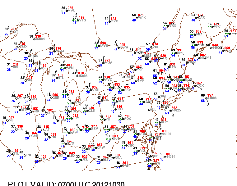
So where is Sandy now? Here is the latest surface map...as of 5 am Tuesday...
And a close-up of the NE...note Reading and Lancaster and KMDT are missing...I'm guessing a power issue? However, Sandy will move the WNW today and allow for some rather chilly air to be drawn down towards us. Today will not be a nice day as temps will remain in the 40s with still some rather gusty winds, but the worst is by far past us as this monstrous cyclone fills.
Here is the initialization (NAM) of Sandy's locale early this morning....note how the cold air has now completely wrapped around what was the "warm core" of tropical Sandy...the lower left panel shows wind, the top right left panel shows surface pressures and temps one mile up....the right 2 are for precip....
And Sandy will move slowly WNW for its location later tonight...
This storm had a SIX standard deviation from "normal" as viewed from the 500 mb level? What does that look like? Well, here you go...deep trough over the eastern US and a huge "block" over the N Atlantic! A perfect meteorological set-up for a storm of this magnitude....
Note how far south the jet stream is! Unreal for this time of year!
OK...that is all for now. Yes people, you lived through history! Over-hyped? I DON'T THINK SO! Talk with anyone who has coastal interests from the Delmarva north to southern NE. My thoughts and prayers are with those who have suffered heartache due to this awesome display of nature. But hopefully this did not result in any bodily injury; merely loss of property. Again, ample warning was given...get out! Although this might appear callus, all indications were that this storm meant business. And once daylight dawns, we will truly see the magnitude of the destruction Sandy dealt to the coastal communities to our east. I'll leave y'all with this...
I hope all is well as can be with everyone reading this.....!
Smitty
AA: One for the record books! I hope you didn't lose power...or if you did, you get it back quickly...