Smitty's attempt to educate and to a much lesser extent, entertain, about all facets of life; but primarily the meteorological and the climatological aspects of the earth sciences.
Those winds of change have paid central PA a visit once again...this time quickly ushering out the preview of springtime warmth we observed the last 2 days. My attempt to get a 70ºF max on Thursday fell ONE DEGREE short as we maxed out at 69ºF....oh well! Today, with a mix of clouds and some minimal sun, along with a stiff WNW wind, we will not get to 50ºF! Here is the NAM's forecast maxes for today, Friday, March 9...
And the comparably coolish temps for highs on Saturday, again with a gusty wind, but possibly abating by late afternoon...in fact, Saturday appears to have a more widespread area of below normal temps for the entire NE US...
All of this is thanks to the cold front that passed through overnight and cleared PA early Friday am. The brisk NW winds are shown here for Saturday morning, hence the 2 days of normal and below normal temps...
But rest assured that these winds will veer around to the SW by nightfall and the 2 weeks of much above normal will begin starting Sunday! Spring Fever Warning to be sure! Below is a map depicting departures for normal for Saturday. Note that much of PA will be at or slightly below normal. Also note the huge area of warmth just to our west poised to advect eastbound with the zonal flow aloft that will be moving across the continental US for the next couple of weeks. Yes, Saturday will be cool...
...But look at Wednesday of next week!
And the following Monday!
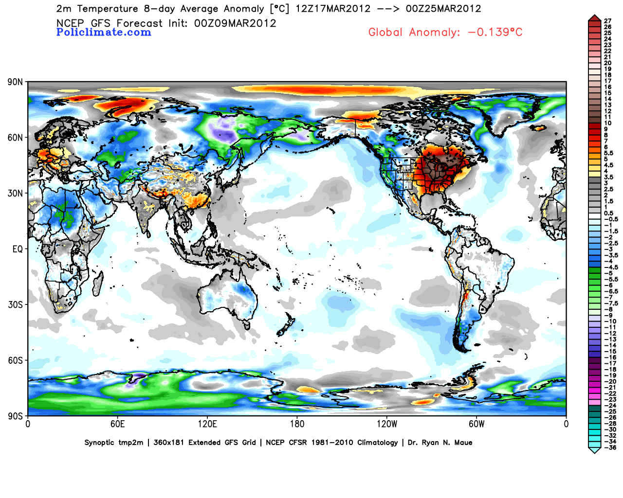
In fact, if we take a look at the 7 day running mean ending March 22, this is simply astounding for this type of departure from normal for this length of time. This will most certainly get many people talking about the infamous "Global Warming"! I predict on a more local note that within 2 weeks, we will notice some people who have over exposed themselves to the increasingly potent March sun and thus be sporting obvious sunburns as a result! But the map below clearly indicates that a global analysis of the surface temps reveals a cool anomaly over the entire earth. It's ironic that the warm areas are the populated regions of the globe...
Speaking of running means, take a look at some other running means...that being the 10, 50, and 200 day moving means of AAPL! Wow! Is there an end to this company's stock's incredible run? The Law of Large Numbers suggests this exponential upward explosion must stop sooner than later...
But if you'd like to capitalize on the back of Apple products, maybe Qualcomm is the way to play this hunch. QCOM can certainly grow and experience growth that will greatly appreciate its stock price over the next couple of years as Apple products continue to expand to the global population. In addition, QCOM is one of the few tech stocks that actually pays a dividend, although a 1.5% DIV isn't going to create a robust stream of income...
Please remember that this author (me) nor the publisher is engaged in rendering legal, accounting, or other professional services by posting on this web site. Smitty shall not be liable for any loss of profit or any other commercial damages, including but not limited to special, incidental, consequential or other damages. As each individual situation is unique, questions relevant to personal finances and specific to the individual should be addressed to an appropriate professional (NOT ME!) to ensure that the situation has been carefully and appropriately evaluated....but I still like QCOM as a Buy!
I hope everyone enjoys their Friday and more importantly their week's end!
Smitty
AA: A coolish couple of days followed by 2 weeks or more of above and much above normal temps!
Just a very brief post here to show y'all the GFS' take on what will be the warmest and the coldest days over the next 2 weeks. We are most certainly heading into a period of above and much above normal temperature wx over the 1st to middle part of March...and likely into the latter part of March as well! Here is the "coldest" day which is this upcoming Friday following a cold frontal passage on Thursday evening with a few showers that will be observed. We are just a couple degrees above normal.
Here is the warmest day which is next Sunday, the day following St. Patty's Day! That is a huge area of 20+ above normal just to the north of PA! I am officially issuing a Spring Fever Warning that will be in effect beginning this Thursday when temps make a run at 70ºF!
Have a good Tuesday afternoon....the last afternoon where temps will remain in the 40s and feel relatively coolish!
A cold front now to our east, which passed through yesterday midday accompanied by those winds of change, will be followed by a trough Sunday
and Monday, pulling away during Tuesday. This will produce primarily a quick shot of colder & drier air along with some instability snow showers closer to Lake Erie. Take a look at the visible satellite pic from yesterday. Note the definitive line of clearing from the wx system that passed off to our SE yesterday, still wreaking havoc in the deep south.
Here is a numerical depiction of the trough at 500 mb coming through the next 24 hours...That is a vigorous trough that will spin up a storm just to our east...Note all of the energy accompanying this trough; no wonder the wx was so feisty the other day!
Here is the ocean storm, just another miss in the winter of 2011-12!
The trough will flatten quickly by Wednesday and a ridge of high pressure will develop over the east...
A surface high pressure will set up over the western Atlantic Ocean, a Bermuda High (although just a tad north) if you will, and
will keep Harrisburg, along with the vast majority of the east coast, dry and allow it to become increasingly mild for the middle to end of next week! Note the SW flow around the 1036 mb high pressure!
Another strong front will be working its way across the mid-section of the country as seen on the map above and below producing what is likely to be another round of volatile wx (although its waaaaay tooooo early to determine is the severity will be as ferocious and heartless) this time focused more on the Arklotex region...
...and those winds of change will once again be ominously breathing down our backs by next weekend once again! But a large area of high pressure (1040 mb) will dominate the northeast and once again provide what at first will be chilly wx, but moderate into something more springlike a week from now into early the following week...
All eyes will be watching what now is a new feature on the numerical modeling; the infamous cut-off low. The old adage is well known in the field; cut-off low is a weatherman's woe! That thing just sits and spins over TX for several days as depicted by the GFS!
For us, the flow "over the top" will mean moderating temps until that upper low decides to do its thing! You can see the Euro keeps the upper low back over the deserts of the SW whereas the GFS has the cut-off reflection over TX. Both the Euro and the GFS overwhelm the lower 48 with mild springlike air for next week, so consistent temps in the 60s look easy for next week...maybe touching 70ºF by Wednesday the 14th!
Look at the NAEFS probabilities for next week's temps! Wow! Spring in its full glory across the lower 48 while Alaska can't shake this winter!
OK...there is a Sunday Summary for y'all! How I see the wx over the next 2 weeks or so. I know many of you are not too much into the tech stuff seeing that we did not grow up with it, but I for one think Twitter is very cool! You can quickly get info and data within minutes...good for being "on-the-go" to and fro. So if you are so inclined, sign up for a Twitter account and check it out. And if you do, you can follow various aspects of society that interest you...including many dandy agencies and their designees that keep followers informed of happenings and events in their niche. I opine on Twitter as well and obviously often do so about upcoming or impending wx. So if you follow @SmittysSynopsis on Twitter, you'll get some quick info on weather data and my oft times intransigent thoughts on other matters of the heart...if you so desire...
Enjoy your Sunday!
Smitty
AA: Roller coaster ride in temps this week...becoming consistently warmer for much of next week!
The spring often brings roller coaster wx or see-saw type wx often accompanied by strong gusty winds. These winds of change tend to usher in colder and drier air following a rain or snow event, but then again, sometimes the same winds of change from the SW bring in warmer and slightly more humid air from the mid part of our continent. Yesterday, much to the dismay of many people in the Ohio Valley, these winds of change were devastating and tragic. Reuters confirmed 26 people lost their lives on Friday as a result of the tornadic storms in spite of adequate severe wx warnings from the NWS. Nearly 100 unconfirmed tornadoes were reported on Friday! Springtime volatility is an understatement.
And this type of volatility will be present in our wx this upcoming week. In fact, the GFS is backing off of its bullishness on the warmth and now beginning to trend more towards the Euro where transient deep troughs of cold air will spill through the eastern US. The Euro has an extremely deep trough on our doorstep for next weekend...where were these cold shots in January???
But here is the GFS' depiction for about the same time later this week. And it hints of a trough, but the upper air pattern suggests against it coming guns ablazin' south and east. In fact, that map below would support temps in the low 60s for us here in southern PA!
Now, in the short term, both the Euro and the GFS do agree that Monday will be cold. Here is just the GFS for late Monday-early Tuesday. Again, I ask rhetorically, where were these troughs in January??? That is cold...and what I believe will be the last true cold day of the winter. Yes, we will have subsequent cold wx, but not to this extent...although the Euro disagrees with me!
Next weekend, one of springtime's bane will possibly play a role in our wx. The phenomenon is known as a back door front. A large area of cold air drains down from New England into eastern PA and makes for a rather cold time of things! Here is the classic set-up as depicted by the GFS for late next weekend. The Euro just blasts the cold into us; the GFS "backdoors" eastern PA and down the east slopes of the Appalachians. What earlier looked like a slam dunk of quite mild air ruling the roost now looks to be in question by a couple of differing solutions. Such is the fickle wx of our spring...
But the winds of change (SW) will bring back the warmth to us by early the 2nd week of March....
In any event, just enjoy the moderating temps March has to offer and hopefully the clear skies from time to time over the next couple of weeks. If the skies are indeed clear, get outside in the early evening and look towards the east where Leo the Lion will be rising with bright star Regulus punctuating the backwards question mark. But, more importantly than this zodiac constellation is the Red Planet just to the south of this stellar grouping. Mars is approaching its most favorable position to be viewed, observed, and even photographed by us earthlings. Every 2.1 years, Mars reaches opposition, a position that places it opposite of the sun and thus in the darkest and closest parts of the sky for us to observe.
I clearly remember the Martian opposition of 2003 which led to a widespread Internet hoax where people were led to believe that Mars would appear as large & as bright as the full moon since it was the closest it would be to earth for the last 60,000 years! True enough in terms of its proximity, but 35,000,000 miles will not allow our companion planet to appear that bright or large in the sky! The moon is only 240,000 miles from the earth...or about 150 times closer than Mars during its 2003 opposition! Here is a diagram showing the Martian oppositions over the past decade and towards the next...Wouldn't those exaggerated ellipses make Kepler proud?
So if you get a chance over the next couple of weeks, a couple of hours either side of midnight, look for the storied Red Planet at about 60º altitude above the southern horizon and with any luck you might see this...
Or not...since the pic above was taken by the Hubble Space Telescope!
OK...I've rambled long enough! For those of you who just click on this to see what off the wall comments I might have for the summation...or music video I stumbled upon to match some of the catch phrases used in the dialog above, I remember this classic from The Scorpions entitled the same as what I titled this post. This hit from 1990 is a favorite of mine and serves as hope for the political turmoil in which this world is still entrenched.
Enjoy...and enjoy your week's end!
Smitty
AA: Cold...then mild....then cold (but not as cold)....then mild....then cold (but not as cold as the 2nd cold)...then mild...all the while with Winds of Change blowing with vigor over the next couple of weeks. Check out Mars...and if you're real astute, note its retrograde movement ~1 month from now!
This is a heck of a springtime storm system complete with heavy snow to the north and unfortunate severe wx to the south. There are distinct sections within the cyclone based upon varying dewpoint and temperature air which is feeding the natural baroclinicity for the storm's ingestion! The radar shot from below shows the complete system in its full glory!
And here is the current surface analysis in shown in relationship to the barometric pressure indicated by the isobars...the gradient as you can see is 2 mb per isobar...that is currently a 988 mb cyclone in its full glory and intensifying rapidly as it feeds on the temperature and humidity differentials...
I took a screenshot of the NWS watches and warnings as of Friday evening...note the tornado warnings in red and see how they correspond to what the numerical modeling depicted late yesterday as pockets of intense vertical upward velocities...the modeling is vastly improving the last several years!
Now look at the 850s from yesterday...remarkable correlation!
Some places in northern MI are expecting nearly 1.5' of snow if you can believe the GFS! Hey Myers, look at the Wasatch Range.....yahoooooooo! You can also see why they only run the ponies at the spa in August!
As for our wx, I do believe we could see/hear some pea size hail this evening with the passage of some of these potent, gusty storms. In their wake, Saturday will dawn dreary and damp, but a strong WSW wind will scour and mix the atmosphere and sunshine should return by afternoon with drying conditions.
The high temps will be achieved early in the day as a rather cold air mass will be moving in for Sunday and Monday. Monday should be the coldest day for the remainder of this "cold" season!
Saturday's temps are shown below for 2 pm...Note the very cold air just to the north and east of Superior...that is poised to move SE and graze us for the Sunday-Monday time frame. If you believe the Canadian and Euro, we could even see accumulating snow from a clipper that will spin up late Sunday afternoon...I'm not sold on that solution, especially for this winter season!
For those of you who are just a little winter weary....for whatever reason; I mean what winter?!?...Here is a little carrot that I'll dangle, especially for any of you who are anticipating a Saturday celebration of St. Patty's Day 2012! Look at the widespread warmth the GFS anticipates for y'all! Not only will you be wearing green, so will the earth in much of our area!
Alright, enough said for this evening. I hope everyone has an enjoyable week's end!
Smitty
AA: Volatile evening across the eastern US Friday night. Colder for Sunday-Tuesday, then moderating. Temps appear to be running above normal for the next 2 weeks. Here's a new twist, a graphic for the AA...80% likelihood of above normal temps...don't see that too much!
Although it will be a couple of days tardy, March will roar in like a lion with numerous severe wx signatures being evidenced on the numerical modeling for late Friday into early Saturday over the Ohio Valley. This morning I showed you this map...this is a colossal area that is penciled in for a moderate risk of severe wx!
Now here is why...1st the surface map for late Friday. That is a strong surface low over Huron with a powerful cold front stringing down SW towards TX. Look at the temp gradient over the lower Ohio Valley with sub freezing temps over IL and IN with balmy temps over the Piedmont of the Carolinas! A major winter wx event will be occurring while a springlike outbreak of severe wx will be occurring over KT and TN. Welcome to spring!
Here is the 850 mb vorticity or spin to support upward motion. Note the sporadic areas from MO to GA where pockets of convection will be spawned.
Also note the surge of deep moisture at the 10,000 ft level (700 mb). Green supports heavy rain and with the vorticity, this should almost certainly create intense convection. Couple that with strong forcing from the cold air advecting SE and the ingredients for a volatile atmosphere are present.
The 500 mb vort map also shows an elongated area of intense upward motion in the area of the front and thus severe wx is likely Friday pm in the lower Ohio Valley. Much of the same area that was hit Wednesday will once again suffer the wrath of nature thanks to the volatility of spring.
Here are the reports from Wednesday. 16 unconfirmed reports of tornadoes with over 100 damaging wind reports is brutal on top of the 26 confirmed from earlier in the week. Welcome to spring.
And spring is notorious for its roller coaster swings in temperatures here in PA. We will have quite a cold Sunday-Monday period before temps begin to moderate for later next week. Here is the GFS' take on the temps for Tuesday; the last of the cold for the next 2 weeks! Oh, we will fall back to normal, but not before a string of what I feel will be at least 7 days at a minimum of 5 above normal. A few of those days will have temps close to 70 degrees! Enjoy the first spell of true springlike wx!
But look how temps quickly switch to spring time warmth by March 12...which happens to be brother John's birthday! Daffodils will be popping in the days surrounding your birthday bro! Enjoy! And frankly, I don't see any crocus crushers on the horizon! This anomalous warmth just coincidentally coincides with our Daylight Savings Time weekend where we will spring forward one hour on March 11! Can you believe we are at that time of year already? Wow!
Note the anomolous heights as per the GFS and the Euro for the 8-10 day period. The Euro is hinting that this warmth is transient; the GFS insists that it is here to stay. Note that AK is once again bearing the brunt of the arctic cold! When it is cold in the 49th state, it is often quite warm in the eastern US! Time will tell...
I've been running silent for a couple of weeks just trying to catch my breath from a hectic winter sports season and quite simply......relaxing. The wx cooperated as there was really no need to opine about any impending winter wx...winter?...did someone say winter?? So I just wanted to give a rather in depth overview of what I believe should be an early arrival of springtime warmth once this last pool of cold departs by the middle of next week. As for running silently, those 2 words lead me to this 1985 hit from Mike and the Mechanics...enjoy this 80s classic!
And enjoy your week's end!
Smitty
AA: Volatile wx in the Ohio Valley Friday into Saturday. That system will sweep a cold front through PA later Saturday making for a cold Sunday-Tuesday period. Then spring will spring!
Just a very quick post here to verify what everyone already knows...this winter was an epic fail! Just 7 inches of snow; no real true arctic outbreaks, one school delay....ONE...we better start addressing this global warming thing! Note the slight upward trend in temps...and also note that last week, we did not achieve 60ºF! Yes...the glories of an ever increasing sun angle.
And speaking of that increasing sun angle...and along with that angle, increasing radiation (heat) creates more volatility in the atmosphere. Thus I show you what is a rather large area of moderate and slight risk for severe wx this upcoming weekend! I can't remember a 2 day outlook that is this potentially ugly! Thunderstorms might even be observed this Saturday noon time around here! Unreal!
Then comes the cold air once again for the weekend. here is the deviation from normal as per the GFS for Sunday.
But by Thursday, we are looking at springlike temps once again...
And so it goes with the roller coaster of spring time...Enjoy your Thursday!
Smitty
AA: Mild Saturday with thunder?, then cold for 2 days, then warm again! Happy spring!