Sunday, October 21, 2018

Suddenly Autumnal

As I sit here this Sunday morning perusing the weather models, maps, and satellite imagery,  the wind and rain are pounding down outside announcing the arrival of yet another shot of polar air.  That large high pressure sitting out over Mizzou and the deep ocean storm off of the New England coast is creating quite a gradient over our region.  Hence the blustery conditions anticipated for Sunday funday.  Below is the current surface map...note the snow showers depicted in the lee of the lakes.
In fact, while glancing at some college football yesterday, the snow was flying in Madison.  Here is a graphic showing the snows around the northern and western lakes for Saturday.  This is the air that will be over us today...
And the forecast temps for Harrisburg over the next 10 days.  I placed a red line on the chart indicating the normal max for this 10 day stretch...quite chilly to be sure for the end of October.
This a map of the the rest of October as per the Euro ensembles...pretty chilly to be sure over the eastern part of North America...

You know it has been quite mild this October here in the eastern part of the US less Maine, but the cold has been bold across the plains of O Canada and our northern plains as seen in the month to date map below.  Also note the warmth over the Arctic Ocean and Alaska, but the cold over Greenland.
In fact, it's been warm over most of Europe as well this October.  The upwelling of cold water in the Black Sea shows up very nicely in the graphic below.  A sea of cold in a continent of warmth.  The cold water from below sure appears out of place, but the persistent southerly flow has done its dirty work and brought the deeper colder water to the surface...pretty neat...

And the Euro seems to think we are in for quite a cold period.  The map below shows the next month's cold air over the next month of time...
But the American Climate Forecast System is at odds with the Euro.  Personally, I have more faith in the Euro longer range modeling. Take a look...
OK...gotta get going.  Kinda knew this was what we were in for with both the weather and the world series.  I will be rooting for the BoSox as much as that pains me.  But I will be more so rooting for some exciting baseball for the upcoming fall classic.  The games being played in bean town will be chilly, especially once that sun sets!
Enjoy your Sunday and this mellow ditty that mentions the changing of the seasons quite eloquently...


Smitty

AA:  Looks to be pretty chilly the upcoming couple of weeks!  The grass will slow down in its growing and you'll be able to enjoy some Red Sox baseball in the WS!

Thursday, October 18, 2018

Changing of the Guard

Wow!  What a difference a couple of weeks make!  Bright blue skies, blinding sun angles, crisp autumnal feel to the air, and the dreaded static electrical shock getting in and out of my car!  In fact, as I sit here and type this, the NWS in State College has issued a Frost Advisory for us tonight.  With clear skies and light winds, frost is a near certainty in many locales in our region.  An even colder air mass will invade Sunday, but I do not think freezing temps will be accomplished as the winds will keep the air well mixed...but Sunday will sure feel cold!  Then, 10 days hence, if this were mid November or later, the much anticipated "S" word would surface...and it will for the mountains of PA next weekend.  Let me explain...

First...the sunrise temps progged for Friday morning...quite chilly to be sure!


Now, the Euro's take on the upper air pattern for Sunday...very low heights for this time of year...
The flow is straight out of Hudson's Bay!  And the GFS is in remarkable agreement...
So confidence is high that Sunday will feel quite autumnal, borderline wintry...and the surface temp anomalies for Sunday...first the Euro...20°F below norms will keep temps in low 40s Sunday if this verifies...

...and the GFS is again in agreement...just not quite as cold.
But what really gets interesting is next weekend...although 10 days out...very interesting!  Here is a classic upper air set-up for a nor'easter as per the Euro...a bit disjointed, but quite intriguing!

And the subsequent surface pressures...big high to the north and a coastal development.  I80 north needs to be attentive to be sure...


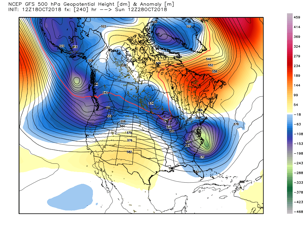
The GFS is even more bullish...with crazy height falls crashing as cold air pours into a coastal low!
OK...enough already...I know!  Calm down Smitty, it's only Rocktober.  So since I didn't blog about Michael, the 3rd strongest storm with deepest pressure to make landfall in the US mainland, I'll leave you with this hurricane rocker...enjoy!  


Enjoy your fall-like weather!

Smitty

AA:  Sure hope the Astros and the Brew Crew can keep things going for some bonus baseball.  Looking more and more like a 3,000 mile cross country World Series!  

Sunday, September 9, 2018

Potentially a NC and VA Nightmare

Tropical systems are like a cork bobbing up and down in water and will move only with any current in said water.  Florence is no different; a tropical rain filled system being gently nudged by any and all atmospheric currents that deem it necessary to move things along.  In the summer months...and yes, we are still in summer despite the autumnal weather of Sunday...the atmospheric prodding is to say at the least gentle.  So once Flo makes landfall, it will be rather hard pressed to move in any direction...thus my concern for an historic flood in the central Appalachians.  Take a look at the Euro's rainfall from this system...
The hills of WVA had some serious issues last summer and if this verifies, the same regions will endure more hardships sad to say.  The morning run had the rain a tad further east...take a look...
Still...the bottom line message appears to be a flood disaster in the the Virginias and North Carolina is in the cards.  Gut feeling on this for us in central PA is a widespread 1-3" rainfall mostly falling Friday...if at all!  Thanks to the large O Canadian high pressure, we dodge yet another proverbial bullet...
OK...I'm out.  Had a nice day with my wife, my faith (which at times is failing I sadly admit), and my friends from Lanco.  On our ride back home from lunch, I usually play DJ...and this song is appropriate for the impending weather for these folks...

Enjoy this and your upcoming week...


Smitty

AA:  Flo to hammer the Virginias and NC with potentially historic rainfall totals...similar to Harvey last year in the greater Houston area!

Saturday, September 8, 2018

Increased Confidence for Tropical Troubles

Just a quick Saturday am update about what is a developing potential problem in terms of inland flooding, coastal impacts (beach erosion and flooding surge), and widespread wind damage near landfall...wherever that might be!  The leading system of the remains of Gordon will set the stage for a potential large regional flooding situation in the Mid-Atlantic.  Here is the total rainfall as progged by the latest Euro by Wednesday with most of this falling now through Monday am...

Here is the latest Euro operational landfall location...Hugo-like if you recall...(ouch!)  The map below is valid Thursday late afternoon...
And here is the Euro ensembles...becoming more and more in agreement with each other, but certainly still quite a spread amongst the many members!
And here is the GFS operational...
And the American ensembles...clearly further north and east and hinting at more of a coastal nightmare than an inland flooding event.
Lastly, the total rainfall 10 days hence as per the Euro...15-20" of rain in the central Appalachians mountains would be a disaster for these places! 
OK...I'm off to Rock Lititz to meet some friends to do just that...rock Lititz!  So for my preparation, I'm going to listen to this classic as I hope you might as well!  Enjoy!

Smitty

AA:  Watching the rains this weekend and the path of Florence wherever she may travel!  I hope not up I-81!

Friday, September 7, 2018

Increasingly Concerned

As most of you know, I peruse the weather and the charts on a daily basis.  Some call it a hobby; others a sickness.  Me, it's my passion.  Example, while we've endured the heat and humidity that has been record setting the last several weeks, how about the earliest sub 30°F reading since the turn of the 20th century in International Falls, MN on Thursday morning!  Spoiler alert; a sign of things to come as O Canada has been quite cool/cold the last couple of weeks!  And of course I've been monitoring the Atlantic tropics and as many are aware, early to mid September is prime time.  I'm now officially concerned that Florence will not disappoint.  The Euro has been quite consistent with a landfall near the NC-SC border and now the GFS has joined the party...hence my concern!  Let me explain...

First the Euro landfall next Thursday pm...
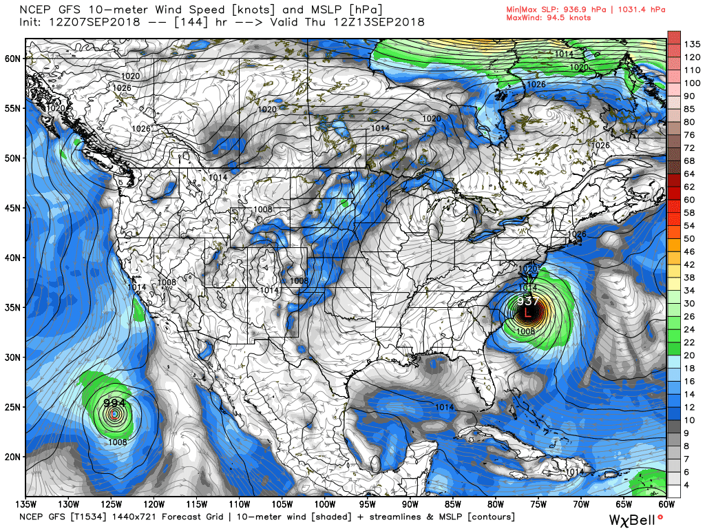
And the GFS landfall...a tad quicker and a bit weaker (barely!)...
Both have textbook synoptic set ups...you can see the paths based on precip totals...first the GFS...
You can see the path of Flo from the tropical Atlantic far off the coast of FLA moving WNW and moving up the spine of the Appalachians...the other heavy rain swath is from Gordon from St Louis to Bangor, Maine!  The mid-Atlantic needs NO MORE RAIN this summer!

Here is the Euro's take...very similar with a disaster for the central Appalachians in terms of flooding rains!  But the 2 global models are slowly beginning to agree on a solution for this tropical menace...
And before all of this, the east coast looks to be under the gun this weekend with a gale from a stalled frontal system...take a look; first winds.  Those are some serious onshore winds later Sunday for the Delmarva and Jersey coasts...
And the subsequent wave heights.  The map below indicates maximum wave heights for Sunday pm...that will be quite a pre-Flo pounding of the east coast and certainly NOT what the doctor ordered!

OK...for my loyal readers, I'll keep y'all posted.  But I am concerned for late next week as Flo looks to mean business!  Just a week out is waaaaaay toooooo far out to have much certainty, but when the GFS has now come on board with the consistent Euro, confidence is growing for a major hurricane to affect the east coast late next week sorry to say.

Enjoy this (which the Tide will most certainly be high on few occasions the next several days!) and enjoy your weekend!


Smitty

AA:  Concerned that a tropical system will deliver more flooding rains to our region or at the very least within 200 miles of our area sorry to say.  A 1-2" rainy weekend as well...

Monday, July 23, 2018

Upper Level Low Creates a July Woe

In terms of rainfall, we've had quite a week of precipitation beginning with a cold frontal passage last Tuesday, a hybrid type coastal system Saturday, and now a stalled upper level low where we here in PA are getting a continuous supply of deep tropical moisture from the south.  As of this time, our humble abode and rain gauge has received over 5" of rain in the last week!  And there will be much more heading our way through mid-week.  Here is a water vapor image from early Monday morning.  The yellow is dry air in the mid-levels of the troposphere while the whites and greens are quite moist.  As you can see from this, the flow is clearly from the tropics and although some dry air is wrapping into the upper low, the high dew point air at the surface will supply the fuel for more showers and thundershowers over the next couple of days...
And the concern of "training" convection can lead to excessive rainfall.  Here is an snap shot of the storms overnight.  Note how they were aligned moving from south to north in response to the upper level low...
And the streams are responding in kind...1st the Yellow Breeches in my "back yard"...
Next the Swatty at Hershey...
And the Susquehanna at Harrisburg...
And here is a graphic showing the rainfall from the last 48 hours in the Mid-Atlantic region...

So we did need rain heading into this week, but we may end up with too much liquid sunshine if this upper low remains stalled to our south and west...this last graphic shows the 5 day 500 mb average with a large 4 corners high and a elongated low from the north central states down towards the SE USA creating our southerly flow on the east side of that trough.  So showers and thundershowers do look likely throughout the upcoming week...
OK...enough said.  I'll leave y'all with this classic song about rain...


Smitty

AA:  Lots of rain the next several days to keep the green things growing.  

Monday, July 16, 2018

Weekend Tropical Troubles?

It's been awhile since I last opined as the weather has been essentially very benign so far this summer season.  Sure, we had an impressive heat wave and an evening of rare EF2 tornadoes rumbling through Dauphin County, but overall this summer to date has been quite uneventful...and that's a good thing.  The rainfall until recently has been generous over most of our area.  As is typical with the nature of convection in the summer, rainfall a bit too generous in some spots while less so in others.  Take a look at precip for the last 30 days.  You can clearly see the thunderstorms that pushed through the middle part of Dauphin County.
It's ironic that here in central PA those tornadoes materialized as nationwide it's been our least tornadic season in the last decade!  The dark black line is the total of confirmed tornadoes across the states for this entire year.  The dotted black line indicates the decadal average of 2005-2015 with the total number just over 1,000.   Take a look...
But this post is to give a brief "heads-up" as to the POTENTIAL of some rather troublesome weather late next weekend into early the following week.  The Euro has been fairly consistent with spinning up a coastal developing storm in that time frame.  Here are the ensembles probabilities of a tropical storm late next weekend along the east coast; these probabilities from this time are relatively high.
And here is the control run for next Sunday morning...a low right over the Chesapeake...
And the total precip along the east coast over the next 10 days with most of this occurring from Friday on...
You can clearly see the track of the coastal system which may have warm core tropical characteristics...FYI...the GFS has not been as consistent with this development, but on some of the runs, it creates a similar situation synoptically.  Time will tell...

OK...gotta roll, but I'll play this one for you as I have before.  It just might be appropriate for next weekend?  Enjoy...and enjoy the cold frontal passage Tuesday which will once again usher in much cooler and drier O Canadian air for midweek!
I'm out...

Smitty

AA:  Watching for a tropical type system to possibly develop this weekend into early next week.  Otherwise, numerous showers and thunderstorms around Tuesday as a cold front pushes through bringing refreshing air into our region Wednesday-Thursday...and even Friday before the muggies return!