Saturday, November 16, 2013

If You Like Your Wx Pattern...

...You can keep your wx pattern, period!  Here is November as we completed half of the month in terms of temps...
Here is the CFSv2 forecast for the remainder of the month...
For us here in PA, the remainder of the month looks like 2nd verse, same as the 1st!  But there are some changes spinning around the roulette wheel of wx! Note how AK is now forecast to get cold and look at how that cold axis is focused towards the eastern lower 48.  Also note how Greenland is turning a bit warmer as before it was cold.  This is known in the biz as a "blocky" pattern, or one that will suppress and slow air masses across the lower latitudes of the contiguous states.  If all of this comes to fruition, then the first part of December looks to be quite cold...and possibly stormy!  The CFS seems to agree...here are the temp anomalies through the 1st 10 days of December...

Now if we can get any precip to attack these "Arctic Highs" that keep coming south and east, we are looking for the potential of a White Christmas.  I'm not rushing the season, but I've had several already ask about such potential...I'd just like to remind y'all that a "White" Christmas is not a frequent occurrence here in the sub-tropics of southern PA!  Take a look...we are roughly a 1 in 4 chance...

But the probability of yet another rotund arctic high paying us a visit is rather high as the WPC shows on its latest maps!
If this map verifies, then Wednesday morning will be quite chilly...no...COLD...in these parts! All indications are that this air mass will be ever so slightly "warmer" than the last; however, with a 1032 mb monster sitting right over PA for the pre-dawn hours would mean the possibility of near record cold by sunrise...just sayin'...The Euro says cold mid-week to be sure!  But it does keep the coldest portion of the air mass over O Canada...
Here are the temps for 1 mile up come later Tuesday evening...
This air will be ushered in compliments of that robust area of higher pressure as shown above.  The predicted rainfall later Sunday night into early Monday morning will mark the cold frontal passage announcing the arrival of the colder air once again...or in the GFS' words, If you like your current wx pattern, you can keep your current wx pattern, period!  The map below depicts 4 hours of radar ending daybreak Monday morning.  
So by Tuesday afternoon, the GFS suggests the surface map to look something like this...a large area of high pressure controlling the eastern part of the USA.  Note that it is really only slightly above normal in terms of its forecasted pressure; (~1.5 SD above norms)...
But a larger and stronger area of High Pressure will be coming for the following weekend, essentially assuring another colder than normal period!  Interesting feature is obvious in the map above (tropical system), but in the map below, a more subtle look to the map is showing low pressure developing in the western Gulf and must be monitored for "Fowl" wx for Turkey Week.  
OK...enough said for now.  But I will leave y'all with this...I was once again very much entertained by the sport of high school football last evening and often look back at a game and try to understand how or why?  The East High tailback carried the ball 30 times once again for 170 yds...but in all honesty, I didn't think he had that many carries!  East High won that game in all aspects last night except in 2 very important categories; special teams (that 70 yd punt by the Dallastown punter was a "game-changer" as was the PI call on the "fake punt fade" play to the DT gunner in my opinion) and the ultimate category...THE SCORE! Nonetheless, the Panthers had a fine season, playing well into November when the majority of teams completed their season's 2 weeks back.  It's just tough to lose a game with only 16 seconds remaining...congrats to both Cats, but most definitely East High.
So who will come out of District 3 AAAA?  An Eagle or a Wildcat, or a Falcon, or a Bulldog?  That's a prediction I'll let y'all make.  I'll stick with the cold wx for the remainder of November!

Enjoy your week's end...and as always...thanks for reading!

Smitty

AA:  It's been cold so far this November...and more of the same is coming!  My favorite time of the year for high school football...but it is just a little cold at times! 


Tuesday, November 12, 2013

Under Pressure

High atmospheric pressure that is!  Once the arctic front passed through this morning with a temperature drop that would make the Plains' states proud, high pressure will be building to the south and east over the next several days.  Take a look at the NWS WFC prog for tomorrow...
For this time of the year, that is one gnarly HIGH!  High pressure, that is where the air presses harder down towards the earth, is characterized by dry and cold air, thus making the air mass heavier and more dense.  And note the 24 hour temp change!
And it's no wonder the northern plains are rebounding as their max temps weren't so much....
It will take the remainder of this work week for the air mass to moderate back towards normal temps.  In fact, for those of you with weekend plans, the high pressure should hold out long enough and fend off any overrunning SW advection that might cause clouds and light precip by Monday?  The Euro seems to think that Sunday will be relatively mild and nice for this time of year.  Here is its prog for the 850 mb temps Sunday morn...
But...another arctic front is on the way!  Here is the Euro's depiction of one mile up for next Wednesday am!  Some of the ensemble members actually have a wave of low pressure on this boundary from deep in the heart of Texas and it marches precip along the boundary towards the Mid-Atlantic.  That solution is seen on all of the global modeling, but none of the actual operational models have anything to get excited about.
HPC plays it by the vest as they have another huge arctic high taking wx control; albeit earlier than the Euro.  We have assumed control...we have assumed control...
And by next Thursday, HIGH PRESSURE will once again rule the roost...at least the GFS thinks so...
OK...I made a reference to a song I heard this past summer that I still can't get out of my head!  It is a pretty awesome 5th inning mid-game song...maybe as good as The O's "Thank God I'm a Country Boy" in their 7th inning stretch.  But seeing east TX has only whetted my appetite to visit west TX now...I hope you enjoy this as much as I...and don't feel "pressured" to agree with my tastes!
Enjoy your mid-week...and your 10°-15°F below normal Wednesday...and that doesn't include the wind!

Smitty

AA:  High pressure to control our wx through the weekend.  Then another frontal passage for yet another arctic high for later next week!  By the way, not an American League guy as you know, but I had a blast at Texas Rangers game!

Monday, November 11, 2013

One Thing For Sure

And that is that the cold is coming! The graphic below shows the precip marking the arctic front as it advances to the south and east...
...and the cold that is advecting SE towards the eastern US!  Look at these apparent MID-AFTERNOON temps! Ouch!
And the GFS' take on a deviation from norms for Wed morning!  Very cold in the deep south compared to norms...just cold for everyone else in the east!
The Euro suggests the that the cold coming will be transient, and some moderation is coming by later this weekend into early next week before the bottom drops out once again!  The top left is Tuesday and moving left to right and down...the bottom right is next Wednesday...so next Monday and Tuesday look rather mild when comparing temps to the norms.
The CFS suggests that the remainder of  November to be cold on average....
So just a very quick cursory look at temps for the rest of November.  No big snows and a phasing split flow that the Euro showed us last week in 4 consecutive runs...oh well...the GFS got 'em that time!  But "King Euro" will take the GFS to school a few times more prior to this calendar year ending.

OK...enjoy your Monday Night Football...and doesn't that last regular season game look somewhat intriguing now between the Cowboys and The E-A-G-L-E-S...EAGLES!

Smitty

AA:  Pretty darn cold for time of year rest of the week.  Wednesday the coldest.  Then moderating (mildest next Monday and Tuesday) until another arctic blast middle to end of next week...


Saturday, November 9, 2013

Snow Po...Wide Right

The potential of the east coast's first winter storm of 2013-14 now appears to be off the table...or should I say off the continent and well into the Atlantic Ocean.  However, the east's first real bout of winter-like temps will most certainly be around this upcoming week as a deep trough will dig well into Dixie and deliver impressively cold air for this time of year with the freezing line advancing into the deep south.  This is all compliments of a monster 1048 mb high pressure as seen here on the Euro...
By Tuesday afternoon, the polar front will have passed well off the coast and a northerly flow will be advectiving cold air into our region.  Here are the 850 mb temps for early Wednesday...the axis of the coldest air will remain SW from Lake Michigan ENE towards the Gulf of the St. Lawrence...
But within 2 days, the deepest chill will be moderating back towards normal...although the surface temps may struggle to climb as quickly...
But where is this storm that the Euro was so bullish on for several consecutive runs?  Wide right!

I'm not convinced this is the final solution as the pattern is changing as the teleconnections of the NAO, AO, and the PNA are signaling a switch from positive to negative or vice-versa...and I'm not convinced this snow output will verify either.  The folks along the SC coast or those vacationing there sure are hoping it doesn't!
Note the lake effect snows downwind of the Great Lakes...especially Lake Ontario and the Tug Hill Plateau! One thing does look likely in the longer term and that a surge of late season warmth will try to make a run at the NE as seen below...
In fact, the climate models are suggesting the same for the 3rd week of the month...

But don't get too used to that as the modeling is suggesting a cold upcoming Thanksgiving season for the east...but PHX looks nice and warm me timing compadre!

Remember, those maps are normalized over several days, so they tend to show tendencies rather than day to day swings.  And the maps are in ºC, so multiply by 2 for a better feel for our temp scale mindfulness...and speaking of mindfulness, keep in our thoughts those adversely afflicted by nature's fury known as Typhoon Haiyan...
Such a powerful storm...but such an impressive natural creation from our maker!
And a still hi-res...breath-taking
So much wx...so little time!  And speaking of time, I'd like to just publicly thank everyone for their kind words over the past couple of weeks as word has spread that I am no longer going to be a part of the CDSD athletics support staff on a regular basis.  I was truly humbled by the numerous comments and well wishes tossed my way.  But now I'll have more time to read about Medium Chain Triglycerides (MCTs), Pulsed Electromagnetic Field Therapy and Stimulation (PEMF), and High Intensity Interval Training (HIIT). I know...sounds like such fun!  But I truly want to stimulate my cellular mitochondria and generate a greater quantity of ATP for cellular regeneration!  I'll also get to read a few more books like Killing Jesus, Napoleon's Buttons, and other non-fiction texts.  For those that know me, that is truly a maturation accomplishment as my ADHD often limits me to reading Twitter ($TWTR) feeds and news articles containing 250 words or less!  I'll spend more time with my family...much to the delight of my kids and grand-kid...
AND POSSIBLY EVEN MORE TIME TO BLOG!  I'm sure y'all can't wait...hahaha!  With that, I'm off to PF and begin my week's end...and I hope y'all enjoy your week's end as well.  And enjoy this ditty from an Album that I've been getting into lately whilst exercising at the gym...ya think they're havin' fun or what?  Jammin' baby!
Congrats CD Rams on a successful football season; sorry to see it end...Go East...Go into York County and continue that playoff ride...maybe all the way to Hersheypark Stadium on November 30?!!

Thanks for reading...

Smitty

AA:  Snow potential looks to be less and less for later this week.  But cold air will invade big time!  Moderating temps then afterwards before getting cold again for Thanksgiving week. But I'll update long before then...here is the Euro meteogram for Harrisburg; that is a COLD WEDNESDAY!


Thursday, November 7, 2013

Comparing The Euro's Runs

Just a very brief post comparing the snowfall progs from the almighty Euro valid next Friday morning...this is simply unreal!  Look at that insane bulls-eye down in the mountains of southern VA & WVA! Is this a precursor of things to come this winter?  Time will only tell...
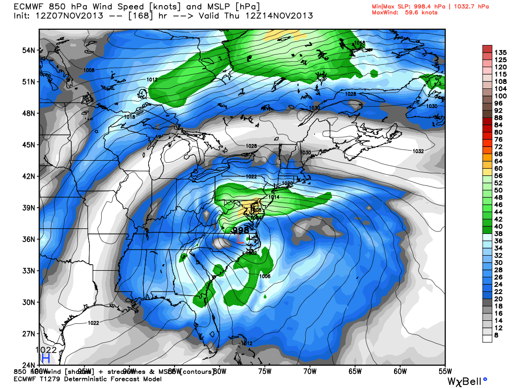
Here is the surface pressure and the 850 mb winds...that is a screaming jet over the Lower Susquehanna Valley leading to copious amounts of precip!  The type of precip would be in question as warm air off the ocean would undoubtedly get pulled in aloft and melt some of the dendrites on the way to the surface...but the surface will be cold enough to support frozen precip!  We are in for a wild ride it now appears...
And that Philly marathon might be a "wild" time as well...if the above earlier run would verify...it might be a "Steeplechase Marathon"!  Ain't winter wx fun?

Enjoy your Thursday evening NCAA special...2 good games on paper!  Just like a good storm on paper above!

Smitty

AA:  Just monitoring the modeling for later next week!

An Early Start To Winter?

Earlier this week, the Euro had a major nor'easter in its 10 day forecast.  Being that it was a 10 day away event, I really didn't heed to much of a warning.  However, now it is in the 7 day realm, and the GFS also has a similar solution, one must begin to wonder if we will have our first major accumulating snow around mid-November?  Here is the meteogram from the Euro for KCXY for the next 10 days.  Snow or not, one thing that looks certain is that arctic air will invade the lower 48 and become involved with our wx beginning the middle of next week!
Note that ~0.75" of precip falls while temps are at or below freezing!  Tomorrow and Saturday will feel like a walk in the park compared to next weekend if the temp forecast verifies...and I believe it will as a monster arctic high is building down from O Canada!  Take a look at this 1042 mb monster!
But by Thursday pm, a deep surface low will attack the high pressure to the north in what looks like a classic set-up for an early season winter-like nor'easter! Banana high to the north, low pressure with ample moisture attacking from the SW, warm ocean offshore setting up a perfect baroclinic boundary in which the low will ride...man, doesn't this get your winter wx juices flowing?
Here is the potential snowfall as per the Euro...this is valid early next Friday am...I don't think I've ever seen a map of this snowfall potential this early in the season!  I will have to check the year, but Myers and myself were traipsing up around Fowler's Hollow in mid-November in knee-thigh deep snow in 1989?  That was definitely the earliest deep snow for my lifetime in these parts...

A deep trough is supported through upper air teleconnections as ample heat and humidity is re-curving along the eastern Asian coast with a late season outburst of tropical cyclones.  Here is the latest (Haiyan)...what a beaut; note the symmetry...picture-perfect!

You know, all of this extreme wx will be bringing out further calls for carbon taxes as we energy gluttonous humans are modifying the wx!  I'd like the global warming crowd to explain this tid-bit...
Or this one...(from last Monday!)

So if this verifies...
...will we see this type of an explanation from the global warming crew?  Just sayin'...
Enjoy your Thursday...and Friday...I might get to update sometime over the week's end!  It will be interesting to monitor the modeling...

Smitty

AA:  Clearing out later Thursday.  Blustery and autumnal Friday-Saturday.  Moderating Sunday-Monday until another major frontal passage and much colder air intrudes for middle to end of next week.  Possibility of snow does exist later next week.

Monday, October 21, 2013

Much Below Normal Temps For Rest of the Month

Ghoulish cool will rule for the remainder of October...at least if you buy into the GFS!  These temps will be more like late November/early December than late October.  It will be cold for sure next weekend in St. Louis when Games 3 & 4 are played in the nation's mid-section.

Again, although not always, but far more often than not, when large cyclones "re-curve" east along the Asian coast, this drives heat poleward which then displaces colder polar air southward over the central and eastern part of North American ~ 10 days into the future...and there is not only one, but 2 "re-curving" typhoons in the western Pacific...one is of real concern to Tokyo, Japan!
As for closer to home, enjoy today's temps as they will be a distant memory in the not so distant future...
Here is the same 850 mb temperature map for Friday Night Lights! That is quite the deep trough over the eastern US!  There will be freezes all the way into the deep south this weekend and next week as well.
It appears that both Friday morning and Saturday morning will bring a hard freeze to the KMDT with clear skies assuming the winds go light to calm.  This looks like the clearest of sky cover over the 5 days which would allow for much radiational cooling to take place prior to sunrise Friday morning.
Lake Effect snow will be flying as well in the lee of the lakes as once again, ~20ºC difference in temps between the lakes and a mile up should crank the snow guns south and east of the Great Lakes!  Here is the current temps of the lakes (now that the site is up and running again!)...
OK...gotta run.  Autumnal is the word for the remainder of October.  And pumpkin is the choice of flavoring many of my favorites at this time of year!

Enjoy the autumnal week!

Smitty

AA:  Turning much cooler...or should I say colder by Wednesday!  Grass cutting coming to an end!