Earlier this week, the Euro had a major nor'easter in its 10 day forecast. Being that it was a 10 day away event, I really didn't heed to much of a warning. However, now it is in the 7 day realm, and the GFS also has a similar solution, one must begin to wonder if we will have our first major accumulating snow around mid-November? Here is the meteogram from the Euro for KCXY for the next 10 days. Snow or not, one thing that looks certain is that arctic air will invade the lower 48 and become involved with our wx beginning the middle of next week!
Note that ~0.75" of precip falls while temps are at or below freezing! Tomorrow and Saturday will feel like a walk in the park compared to next weekend if the temp forecast verifies...and I believe it will as a monster arctic high is building down from O Canada! Take a look at this 1042 mb monster!
But by Thursday pm, a deep surface low will attack the high pressure to the north in what looks like a classic set-up for an early season winter-like nor'easter! Banana high to the north, low pressure with ample moisture attacking from the SW, warm ocean offshore setting up a perfect baroclinic boundary in which the low will ride...man, doesn't this get your winter wx juices flowing?
Here is the potential snowfall as per the Euro...this is valid early next Friday am...I don't think I've ever seen a map of this snowfall potential this early in the season! I will have to check the year, but Myers and myself were traipsing up around Fowler's Hollow in mid-November in knee-thigh deep snow in 1989? That was definitely the earliest deep snow for my lifetime in these parts...
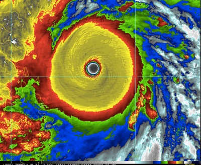
A deep trough is supported through upper air teleconnections as ample heat and humidity is re-curving along the eastern Asian coast with a late season outburst of tropical cyclones. Here is the latest (Haiyan)...what a beaut; note the symmetry...picture-perfect!
You know, all of this extreme wx will be bringing out further calls for carbon taxes as we energy gluttonous humans are modifying the wx! I'd like the global warming crowd to explain this tid-bit...
Or this one...(from last Monday!)
So if this verifies...
...will we see this type of an explanation from the global warming crew? Just sayin'...
Enjoy your Thursday...and Friday...I might get to update sometime over the week's end! It will be interesting to monitor the modeling...
Smitty
AA: Clearing out later Thursday. Blustery and autumnal Friday-Saturday. Moderating Sunday-Monday until another major frontal passage and much colder air intrudes for middle to end of next week. Possibility of snow does exist later next week.


No comments:
Post a Comment