Smitty's attempt to educate and to a much lesser extent, entertain, about all facets of life; but primarily the meteorological and the climatological aspects of the earth sciences.
I know it's been awhile...a long while to be sure. It was about 10 days prior to Harvey wreaking havoc in the Houston area that I last blogged about the weather and weather there was! Harvey, Irma, Jose, and of course Maria. But for us, the weather was rather benign. In fact, when the temps are above norms in October, well, in my humble opinion, that's kinda nice! Here is the last 6 weeks to date in terms of temps...
But I believe the month ahead of us will slap us hard in terms of a polar opposite temperature anomaly...the onset of winter is already starting with a nice late October winter storm across the north country of Minne-haha tonight...take a look...
On the other side of the pole, the snow-cover is being laid down a bit earlier than normal as well...much of Russia (collusion...sorry, I was just associating freely!) is covered with the arctic blanket.
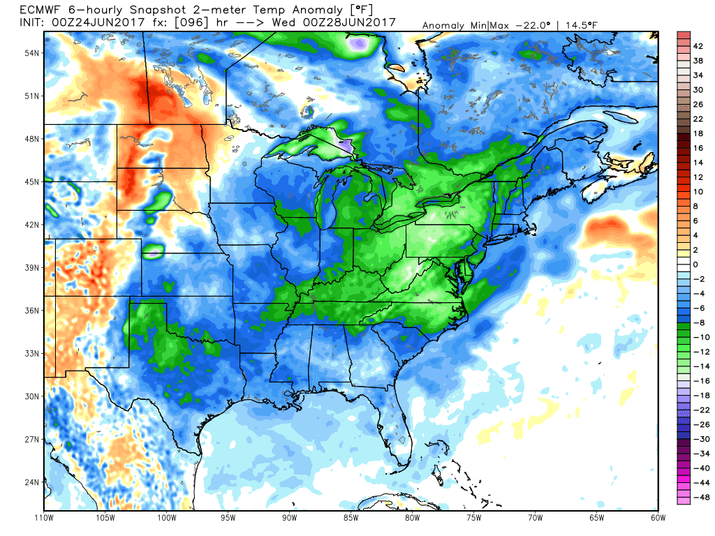
So with all of that said, we have an air mass that started on the other side of the pole that will be digging deep into our continent...take a look! Those blue-purple-green colors indicate a serious change in the weather; a rude awakening to be sure with the anomalous warmth we've experienced for the last several weeks!
And as for how dry it's been, that's about to change as well as a tropical disturbance looks to phase with this digging energy from the northlands and the proverbial "pour gasoline onto a fire" will bomb a storm off the east coast this weekend...take a look! Not a total phase as the little tropical piece lays off to the SSE...if that would entrain...well...watch out!
And the heavy rains overnight Sunday into Monday...the graphic below is only a 6 hour snapshot of precip!
Here's the total precip through early next week...
Ok...'nough said...just trying to get back a feel for this blogging thing as I've had many ask "where's the posts"? So with this changing pattern, I thought I'd clue in my loyal readers...and as always...thanks so much for reading!
I've listened to a nice quantity of quality music this evening and I'm not sure what I should include and share with y'all...but I did mention Maria earlier. And for my bud, Chuck, I'll embed this recent classic from Carlos...enjoy!
And enjoy your Halloween Penn State over OSU weekend!
Smitty
AA: Getting colder and wetter for the foreseeable future! And I do me colder...and wetter!
As I continue to monitor the situation with blowhard Harvey, I am also keeping one eye on soon to be Irma...at least I believe so. And although the Euro and the GFS keep Irma out to sea, the Canadian global numerical model has a rather concerning solution...especially in its previous run...take a look...
The above scenario would be a bit disconcerting for us here in the mid-Atlantic. With that said, the trend of the model is now to keep it further away...and that is good news! Take a look; first off the Outer Banks and the VA capes...
And then 6 hours later pulling away with the Gulf Stream...here's hoping. Bottom line; must keep our watch for soon to be Irma...
So you know my deal...gotta leave y'all with a good tune. The top most graphic would be an affirmation for the song sung below...Enjoy!
Smitty
AA: The Canadian is a fairly reliable model and this has me a tad concerned for the middle of next week. Just get your mowing done!
It's no secret now that Hurricane Harvey has it eye set on the central Texas coast and that as it slowly approaches landfall, it will eventually stall over SE TX before pulling back to sea and sending its moisture eventually our way. It has been TWELVE years since a Major hurricane has made landfall in the US; Wilma was the last in the epic year of tropical troubles in 2005. A major hurricane is one that is Saffir Simpson Scale 3, 4 or 5. Take a look at the Saffir Simpson Scale for Hurricanes...
Hurricanes are a lot of wind, but more importantly they are a ton of rain and water! With the slow movement progged for this storm, some very heavy rainfall totals, record breaking in some areas, are likely with this storm. Here is a close-up of the rainfall totals from the go-to global Euro model...the regional models have even higher totals! Coastal flooding will also be severe as the storm slowly grinds unto the coast and water piles on the NE side of the storm with surges of ~10' or so...wow!
Just off the coast of Galveston Bay (in the graphic above) has nearly 3' of rainfall! It's not out of the question for some areas to actually record 3' of rain with this devastating event. And as I mentioned earlier, the remnants will eventually track up towards PA, possibly giving us a rather wet time of it for the 1st part of the Labor Day weekend...use the graphic below to track the moisture...I personally believe the track of the heaviest rains will somewhat follow a bit further SE and up the Ohio River valley...also note the the heavy rains over South Florida and just off the SE coast. It looks like a near miss with what I believe will be Irma by Friday am...
Here is a graphic showing the Thursday pm positions of both Harvey and soon to be Irma?
And the current watches and warnings in these troubled tropical lands...note the frost advisory for the UP of Michigan. That cool crisp O Canadian air will control our wx for the next several days...so enjoy!
I'll leave y'all with this 8.5 minute gem; truly a bluesy time will be unfortunately had for these resilient folks of Texas...
Let's all hope this storm is not as bad as what sure looks like will occur...and let's keep that Irma? system from developing too close to the coast of the SE USA. Enjoy your pre-start-of-school 3 day week's end!
Smitty
AA: Really hoping the people in TX heed the warnings; Harvey (how appropriate, a real blowhard!) looks ugly from my seat; FL and the Carolinas to be spared this time I do believe, but just by a hair on my chinny chin chin...and you know I've gots lots of those! Catch up on your mowing!
It was excellent to see all of my colleagues today back in the saddle in the CDSD and with that, it got me to tickle these keys again as well. This post will not be about the eclipse; it was awesome to be sure, but the fact that over the next 5-7 days, a couple of tropical systems are going to create real headaches for coastal Texas and coastal Florida and the coastal Carolinas. Let me explain...and I will be brief. Here are the projected rainfall totals across eastern Texas as modeled by the Euro...
And a close-up of those epic rainfall totals centered on Houston and Galveston Bay...
TS Harvey...which should ramp up into a Cat 1 or even Cat 2 storm by Saturday will pound those coastal TX communities for a good 2 days or so...well...maybe not so good! As for the Florida situation, soon to be Irma will slowly ride north along the east coast of FL. Here, the Euro keeps the heaviest rains over the Bahama mamas, but personally, I believe some very heavy rains will manifest themselves from Miami to the Space Coast...just sayin'...then the Carolina coasts must be made aware...
OK...enough to let y'all know that tropical troubles are a brewin'. And in honor of Glen Campbell, who passed earlier this month, and since I mentioned this geographical location above, I'll leave y'all with this...Enjoy! And enjoy this glorious end of summer, low dew point weather for our area!
Smitty
AA: Just a post about some tropical systems that I'm not hearing too much about, but I believe we will after the weekend! Good grass cutting weather the next entire week! Enjoy!
As we begin our warmest month of the summer, I always like to look ahead and try to see what the modeling is suggesting for the upcoming month. But before I do that, let's look at the month behind us. As most of you know, we just completed a glorious stretch of weather earlier this past week. In fact, it was actually very much below seasonal norms in the upper mid-west and northern plains, but here in our area and the mid-Atlantic in general, although cool, the heat returned triumphantly. There was essentially a mini-heat wave centered in PA...here are the last 2 days...note the cold in Manitoba!
And the last 2 weeks...note the heat in the famous megalopolis from DC to Boston...
And if you're unsure of a megalopolis, here's a graphic of population density for the I-95 corridor; the darker the shade of brown, the greater the population density. The darkest shading indicates regions in excess of 7,500 people per square mile!
Sorry I digress...you know, my ADD just kicked in! Now, how about the last month in terms of temps? Look at how the heat held serve around the Chesapeake Bay much to my wife's dismay as we sit at Oriole Park at Camden Yards in a pool of sweat watching the Orioles tank during this past month! Ouch...like my lovely wife says, baseball is about the pitching and the Os have had little quality pitching this past month! Now yet another digression; baseball flavored this time...sorry. Here's the map of the past 30 days...
So what might July hold in store for us in terms of temps? First, the Euro's take on the next 5 days at the 500 mb level. A net flow in these parts from the west and southwest with slightly above normal heights. That would indicate temps at or above climatological norms with relatively high humidity...
And for this upcoming weekend after the July 4 celebrations...a weakness in the upper air over the eastern portion of the continent could pave the way for slightly cooler than normal temps and seasonal humidity levels. The pattern below also spells heat will once again invade SW deserts and the 4 Corners region of the US...
Here is a snapshot of the Euro's next 10 days in exact numbers of highs and lows; next weekend it appears a new refreshing shot of cooler and drier air may invade from O'Canada on a strong upper air NW flow before yet another surge of heat humidity invades for the middle of the month...
And July as a whole...slightly cool in the eastern half of the CONUS; warm western half. Do note that consistent tongue of warmth over the Chesapeake Bay region...which to me indicates strong down-sloping and therefore warming with WNW flow off the Appalachians...
OK...enough.. July is summertime and with it is heat and humidity. So enjoy the summer season and enjoy this hit from the 70s...
Smitty
AA: June was basically normal in terms of temps in spite of the hot spells and strong cool downs...July looks to be similar with no real prolonged periods of heat and humidity; just a alternating mix of cooler times and warmer/hotter times...and, oh by the way, we live on the northwest fringe of a very densely populated region of the US...but you already knew that having to drive I-81 all the time! Looking forward to ASG at Bluebird!
I'm up early this Saturday morning thanks to a train! But not what most think of when they hear the word "train". I'm talking about training cells of convection! The rain has been pounding down for a few hours here at my humble abode and has awakened me from a deep slumber. The sound of large drops striking our sunroom's glass is actually quite loud. Hence, my awakening! Of course, I scoped the radar and from there, here I sit studying the weather...again! Here is how training showers depict on a computer model for precip output...note the train is a'rollin from West-by-God-smile-when-you say-it-Virginia to New York City...
But by the time when many of you peruse this, the train will be long gone! And a glorious air mass from our neighbors to the north will be invading our country. The strongest part of the anomalous cooling will be to our west; however, we here in PA will benefit with cooler and much drier air for the next several days. Note the below normal temps in the Dakotas, MN, and WI for Saturday...
By Tuesday, the coolest of the summer temps will arrive here in PA...take a look...
Not only is it cool, the air will be very dry! Here is a map I seldom show; precipitable water in a column of air. This is a metric of essentially how much water could be squeezed out of the air if all of the moisture was to precipitate out. In the winter, PW is quite low; in the summer, it has the potential to be quite high, especially in the tropical air masses. Look at how low the PWats are for Wednesday am...but also note the stream of moisture advecting northward from the western Gulf to Lake Winnepeg!
So by next weekend, the heat and humidity both return to us here in PA...
In fact, the map above shows the warmth returning by Thursday! And by next Saturday...well...here ya go...back in the "yuckies, muckies, and stickies"...note the anomalous humidity as per the "PWats" training directly over our lovely commonwealth! Also note the 2 areas the model believes storms will be likely; just west of my son in STL and over God's Country in northern PA. (Might be some blown out streams Goldy next weekend...?!)
As for July...here is a quick look as per the CFSv2...but don't get too excited as this is the first time it has shown such a "cool" signal to the middle part of the country into the east...too much to show, but the last several runs of the climate model was showing widespread warmth across the CONUS...but is that surprising? Even the modeling has a warm bias in these politically charged times of global warming! Ha!
OK...enough! I need another coffee with my MCT. Now, some of you might be wondering...probably not...but MCT? Medium Chain Triglyceride...another story for another day! Enjoy your weekend and the the invading train of cool to roll through our state this upcoming week!
And enjoy this throwback to when I was a kid!
Smitty
AA: After the overnight rain that brought up to two inches in some parts of our area, a much drier and cooler air mass will pay us a visit for the next 5 days! Highs in the upper 70s to low 80s with lows in the mid 50s! I think Wed am, there will be temps in the 40s in south central PA! But not at KMDT as that is the official reporting station and we wouldn't want such cool temps being officially recorded! Good mowing and landscaping weather to be sure! And Yokes...good paver laying as well!
I'm doing back to back posts to show you how consistent the models are or are not from 18-24 hours ago. I will show you the current outputs from the 3 global models and the one tighter grid model that I showed you yesterday. Model consistency is something that leads to forecasting confidence. For me, it's but a hobby; for many, it's their bread and butter! In addition for this weather thing being my hobby and since I've been doing this weather watching thing all of my life since I was a "crumb-snatcher" (an affectionate term often used by my wife), when a plume of tropical moisture surges northward towards a diving trough from Canada, be aware of heavy downpours and training convection here in the Mid-Atlantic! I've seen it many times before and will see it many times going forward. So, here are the total precip outputs all valid for Saturday morning...the same time frame I showed you yesterday.
First the Euro...
Next the GFS...
And the O'Canadian...note the "dome" over the PA turnpike from Breezewood to Bucks County!
Lastly the higher resolution NAM...
I believe the message here is expect some fairly robust precip in these parts (much needed I might add) and there is a possibility, or more like a probability, that locations a mere 50-100 miles apart will see a vast difference in rainfall totals. That is to be expected with convective, tropical systems. Here is the most recent outputs from the storm tracks of the center of lowest pressure (Cindy's remnants) from numerous models...
And the top view of how Cindy and her associated deep moisture looked early this Thursday morning...the center of lowest pressure located just northeast of Houston...
So from observing the models and numerous past similar synoptic set-ups atmospherically, I expect Friday to be a "rain-out" with on/off heavy showers and even a few thundershowers with the bulk of the rain departing by mid-morning Saturday...by the way, this Sunday looks to be a "Chamber of Commerce kinda day! Enjoy!
And enjoy this tune about what's happened to some extent the last several hours down in eastern Texas and other parts of the deep south...
Smitty
AA: Warm and increasing humidity on Thursday sets the stage for a washout for Friday with about 1-2" of rain by Saturday morning. Front pushes through and much drier air for Sunday through the bulk of next week...