Smitty's attempt to educate and to a much lesser extent, entertain, about all facets of life; but primarily the meteorological and the climatological aspects of the earth sciences.
This upcoming Memorial Day weekend will be HOT! I just want to post a few graphics indicating this. The first is the forcasted 850 mb temps for next Monday afternoon...downright hot at the surface if this verifies!
Now the surface map actually shows some form of convection developing (thunderstorms) for the 6 hour period ending Monday evening...and that is not out of the question. However, I do believe that convection will be limited until the frontal system out to the west will advance eastward towards PA.
The 700 mb relative humidity is quite low and thus the air would need to really work at saturating the column for precip to occur without any decent forcing to lift the air. The buoyant heated air will most certainly rise, but the moisture is not too deep!
And we are protected with the 500 mb high pressure system as seen below...so in my opinion, convection will be hard pressed to fire on Memorial Day.
According to the GFS, Monday will be the warmest day from normal...~15ºF+! Toasty!
And the warmest 7 day period will end on Wednesday...so a cold front will be coming through to knock temps down back to normal and even ever so slightly below normal.....
So close, but yet so far....it would've been beautiful the other way!
I Like Dreaming....some say this had to do with my purple shirt I sported today! I like to think of it as just missing 2 sizable wagers on The Derby and The Preakness. I'll get back in the saddle for The Belmont! I'll spare you the Aerosmith version of Back in the Saddle.....
Enjoy your mid-week.....and go Rams Baseball.....
Smitty
AA: Increasingly more summer-like as the weekend progresses! Downright hot Sunday/Monday!
Since the weather this Saturday will be one of the top 10 weather days of all year (Sunny and ~80ºF), I felt compelled to share just a bit about the annular eclipse that will be occurring over the Pacific rim this weekend. I will also expound in just a very brief manner what the oscillating Pacific Ocean might imply for our weather this upcoming winter season...but before I go there, look at the 500 mb pattern for late Saturday...controlled by high pressure! That trough (or weakness in the upper air pattern) to our south does spell trouble however for early to middle of next week.
Here is the total rainfall forecasted by the GFS for the period Monday through Wednesday...I believe that the "blue" area over VA will be a bit further north and over us here in southern PA. But we will see what we will see....
But there is no denying the wx for this Saturday and Sunday as high pressure rules the roost! That low off the Carolina must be watched for early next week as the high pressure will fade off to the ENE...
But as for this upcoming solar extravaganza, our fellow citizenry of the western part of the US will be treated to an annular eclipse as the sun sets this Sunday. An annular eclipse is one where the moon is unable to total cover the sun as its distance is just too far from earth and thus appears too small in terms of its angular size in the sky. Kinda ironic since 2 weeks ago a "Super Moon" was being hyped as it was closest to the earth in conjunction with full moon phase!
Earthlings, as a result, will see something that looks like this if they are in the path of "annularity"...
And here is that path where prime-time viewing can occur in our country just prior to sunset...Winslow, AZ might be a nice place to catch this celestial event...at least that's what Jackson Browne alluded to in his 1972 song here authored and sung most famously by Glenn Frey and The Eagles!
Follow spaceweather.com for excellent updates or any other link from there to view this eclipse via the world wide web, and what observers in the path are willing to share!
As for our upcoming El Nino, here is a forecast of the Sea Surface Temps (SST) and the on coming El Nino, albeit a weak signal, for the next several months.
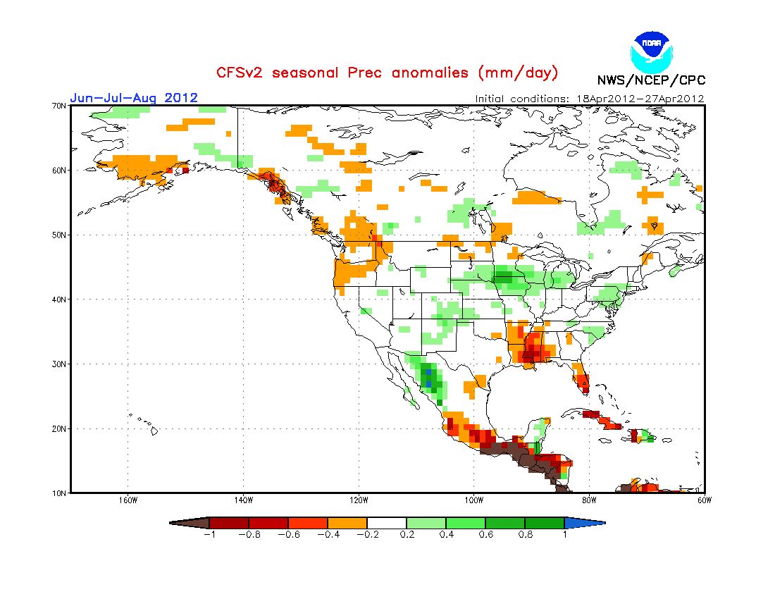
Based on the Climate Forecast System, here is what the upcoming summer might hold based primarily on the these oscillations in the Pacific ocean, THE PRIME DRIVER OF THE EARTH'S WEATHER PATTERNS AND NOT MAN! Basically a weak signal for warm in the western US and no real clear signal in the east...
And here is precip...a weak wet signal over PA with slightly stronger signal over the upper Mississippi Valley and dry in the lower Mississippi Valley and south FL....
This is all interesting to me...maybe not so much to y'all, but I find it fascinating that these climate models are actually on the improve as more input from the Pacific Oscillations (El Nino/La Nina) are being introduced!
Enough for now...listen to the Eagles' "Take It Easy" thinking you are in Winslow, AZ watching an annular eclipse this Sunday evening!
Enjoy this gorgeous weekend!
Smitty
AA: Nice weather this weekend! Solar eclipse out west. Summer looks "normal", maybe slightly wet here in PA based strictly off the latest climate modeling.
Just a very quick post this morning concerning our recent rains this past week. As I'm sure many of you observed, the sky yesterday afternoon had "convection" written all over it in the form of those beautiful towering cumulus clouds...some of which evolved into Cb. As I checked my rain gauge before the sky completely darken last evening around 9 pm, glancing to the east, I observed lightning flashes off into the distance. Many of you had a nice couple of days of rain, but our annual precip deficit remains at -1.60" for the year at KMDT. Here take a look...focus on the middle graph for rainfall/melted precip. The deficit is essentially from March 1 as we were at "normal" on that date. Also notice the coolness of May with the top temperature graph...
Here is a map of the Susquehanna watershed over the past 72 hours...that's 3 days for you Yokes! The heaviest of the rain fell over the northern part of the basin...however, Yokes would swear that the orange speck is right over his house where the deficit has been erased in qualitative, not quantitative opinion!
And with that rainfall comes the rise in the Susquehanna River. Here is the flow increase over the past 7 days! Quite a turnabout from the beginning of the month...don't cha think? Might even have a few blowouts up north Goldy!
As for our ground water levels, a similar pattern can be observed compliments of the recent rains!
The next several days, once we get past the last threat of storms this afternoon between 4-8 pm as a dying front passes through central PA, will feature beautiful springtime wx with sunny skies, light to moderate breezes, and temps in the low to mid 70s. By Sunday, we might be around 80ºF once again. Look at that 1024 mb high right over NE PA for Friday morn...she's a beauty!
As will be Bodemeister standing in the Winner's Circle at Pimlico after the 137th running of the Preakness Stakes!
Have a great Wednesday....
Smitty
AA: Slight chance of a shower or t-shower this pm between say 4-8 pm...then beautiful wx through the week's end! Follow me on Twitter...I've been putting out quick updates there...its just faster and easier and more efficient...watch out as my team is starting to wake up!
Saturday will be cool, check that, downright raw, and wet. Sunday appears to be drying out albeit with cool, gusty NW winds. Just a very quick post to summarize this weekend....First, here is a map of the total precip that will have fallen by Sunday afternoon. Most of the rain will fall between the hours of 2 pm Saturday until 10 pm Saturday evening. The NAM has the target of heaviest rain in north central PA. I personally believe the bulls-eye will be in south central PA....time will tell.
Saturday potentially will be ugly cold for this time of year...look at the starting point temperature-wise for early Saturday morning. Man-o-Man, that is chilly!
Lastly, skies will clear rather quickly Sunday on gusty NW drying winds. Of course, there is no free lunch....so winds from the NW will usher in below normal temps for this time of year...although the sunshine will most certainly take the sting out of the air in the middle of the afternoon. I do believe a WIDESPREAD FROST is very likely Sunday night into Monday morning once the winds subside and high pressure sets up shop right over PA late Sunday into Monday. In fact, sub-freezing temps are possible with this synoptic setup! Just consider yourselves advised!
But temps will rebound quickly by the middle of next week.....take a look for Prom Friday! I believe max temps will achieve 80ºF either next Thursday or Friday......
In closing, Humber gives up 9 earned after his perfecto! Most ever by any pitcher after pitching a perfect game! Wow! Also, the NJ Devils scare me....always have....always will! I hope the Flyers can get their nemesis out of the way onto Lord Stanley's Cup! Go Flyers!
Enjoy your week's end!
Smitty
AA: Cold and damp Saturday; drying, breezy, and coolish Sunday...but much brighter! Flyers in 6 over the Devils?
PA appears to be in store for one cold and dismal weekend with lots of low clouds, cold NE breezes and nearly and inch of rain (with a few snowflakes thrown in for good measure, especially in the higher terrain) when all is said and done by Monday morning. Let's take a look strictly at the temps over the next 3 days...starting with...
FRIDAY:
SATURDAY: (the purple is -18ºF below normal and suggests snowfall!)
SUNDAY: (normals for KMDT are mid 60s...so look for highs in upper 40s!)
And by Sunday afternoon, here is the total precip that is modeled for PA...some of the places that received the snows earlier this week will actually see another snowfall of ~2-4" in the higher ground by Sunday morning....AGAIN! It's nearly May people! The forecasted temperature profile actually suggests at this time a few wet snowflakes will mix in the rains here in the Harrisburg area late Saturday evening!
But, what a difference a few days make....take a look at the temp anomalies for next Thursday...much above normal (+12ºF) for PA!
In closing, this cold wx has to have you somewhat in the mood for the NHL playoff hockey. I guess most of New England is now going to shift their attention to the struggling Red Sox since their beloved Bs will be on the golf course compliments of the Washington Capitals! Now for Ottawa to oust the NY Rangers....
Have a good Thursday!
Smitty
AA: This weekend looks to be much below normal temperature-wise and quite damp....
This will be an historic springtime nor'easter; one for the record books! Flooding rains on the east with damaging heavy wet snow to the west. Rapid intensification along the Carolina coast will generate extremely strong wind gusts as air is sucked into cyclone. Gusty ENE winds will cause higher than normal tides and coastal flooding especially since we are one day past new moon! Astronomically, the set-up is perfect for coastal erosion! Here is the tide chart for Cape May, NJ. The circled high tide is the one of great concern for the New Jersey coast.
As for the effects of this storm inland, this is a direct quote from the NWS office out of Sate College..."THIS STORM WILL BE EXTREMELY DESTRUCTIVE". Again with the weight of the heavy wet snow, even a few inches will wreak havoc upon the western and central portions of PA and the mountains of WV along with upstate NY! Here is the probability of AT LEAST 8" SNOW for Monday! Personally, I believe this will be a bit further east as per the European model. Wow!
And so does the forecaster from State College...another quote..."AS FAVORED ECMWF SOLUTION REMAINS FARTHER EAST WITH SYNOPTIC FEATURES WITH A COLDER BOUNDARY LAYER OVER THE CENTRAL AND SOUTH CENTRAL MOUNTAINS..." and here is the Euro output for late Sunday night! Look at that 988 mb monster. Quite impressive!
And the Euro upper air prog for the same time. Man I wish it were winter! That is a textbook example of a full latitudinal phase. Atmospheric synoptics don't happen like this too often...although the global warming crowd will capitalize on this event no doubt!
Here is the regional NAM's best guess as to the total precip from this storm. Again, I believe the "lighter green" bulls eye will be a bit further east...sort of over the Susquehanna Valley with the heaviest precip falling over the DE River and the Allegheny Plateau. I look for KMDT to receive ~1.50" rain from this intense system. The stronger is develops, the more dry air will be able to actually wrap in at the mid levels and actually decrease the rainfall for KMDT!
So, one for the record books as was pitcher Phil Humber's perfecto yesterday against the lowly Mariners. Nothing can be taken away from a pitchers' perfection, but I did hear some talking head try to do just that saying its luster was less brilliant since it was versus Seattle. That's total baloney! They are a major league team with major league talent and possibly one of the better hitters in MLB history even trying to get on base via a bunt which is his forte. So congrats to the ChiSox' Humber, a former Met and Tommy John patient by the way, on pitching the 21st perfect game in MLB history!
Now maybe the Flyers can be the icing on this weekend's sports front. I heard somewhere that a major nor'easter is going to take the cake on the weather front!
Enjoy your Sunday!
Smitty
AA: Nor'easters, perfect games, and Stanley Cup playoffs! Doesn't get much better for springtime!
Just practicing my alliteration phor the title. Sorry...Now hear this...This storm will be nothing short than historic for the mountains of WV and PA! Now how is that for my extremism?!? But it is April 21 and we are looking at a classic nor'easter that if it were winter, we'd be hearing this event given the moniker "Storm of the New Century"! If the 12Z NAM snowfall forecast would verify, PA will be declared a disaster area where the snowfall accumulates in excess of 4". This will be horrendous as the weight of the heavy wet snow will down trees and power lines especially since the trees are in full foliage due to the early spring! Take a look at this model!
I think the Pirates might not play on Monday although the Colorado Rockies used to this type of weather....well....sort of! Here, let's take a look at the current visible satellite pic of the gathering gloom...look at the cyclonic circulation already prevalent in the Gulf of Mexico! Also note the clouds over MN, ND, SK, & MB. The clouds over the northern plains represent the match that will ignite the fuel which is being seen over the Gulf coast states. Isn't this exciting? If this were January, East would be dismissed already for Monday!
Here is the latest prog of the upper air (500 mb) for Monday morning when the negatively titled trough will grab the southern part of the storm and pull it NNW! That 534 mb closed upper low and all of that vorticity or spin right over us will almost certainly guarantee thunderstorms Monday morning! This is the type of map I would draw while sitting in Electricity and Magnetism struggling to understand anything about Faraday or Gauss. That is why I was so happy with "D" for done for what was my most challenging class at PSU! By the way, nice wx down in the 4 corners area of the US!
And here is the surface reflection of the above air synoptic set-up...
Central PA could be spared the worst of this as the cold conveyor looks to be over the western half of PA...The Allegheny Plateau...while the central mountains and the Susquehanna Valley might get "dry slotted" just a bit. It's too early to be certain as the exact path of the center of lowest pressure as a shift of only 50-75 miles further east would very likely allow for some accumulating snow to occur on the mountains just north of Harrisburg! With all of that said, I am still issuing a barometer watching warning as the pressure may drop to 28.70 mb at KMDT sometime Monday morning! The lowest pressure I've recorded at my humble abode here in northern York County is 28.71 mb with a storm back in January 2009. Winds will be very gusty as depicted by the isobars and if there is any snow on the trees in the mountains, it will take weeks to clean up this devastation! Here is the NAM's winds for Monday morning. You can clearly locate the center of low pressure over ACY around noonish Monday!
And here is the NAM's total precip over the next 72 hours! You can clearly locate the "dry-slot" over central PA. Truth be told, i am a bit nervous about this thing becoming so strong that is does draw in dry air towards the center of circulation and robs us of our precious drought busting rains we so desperately need! Take a looksy.....
I mean, check out the Susquehanna's discharge compared to normal for the last few weeks. We sure could use the rain just like the Flyers sure could use a victory in Game 6 since if their series goes to a Game 7, well, they surely should mobilize their summer plans as their season will most likely end Election Day Tuesday thanks to those Pesky Penguins!
For just some kicks and giggles, since it's hard for me to look past this impending historical April nor'easter, here is what the GFS and the Euro have for the beginning of NEXT WEEK or about the 1st week of May...both are in reasonable, dare I say, excellent agreement with residual NW flow but some warmth from the plains on the doorstep for CD prom weekend...
So it looks like a stormy couple of days...especially a Stormy Monday! If you have ~10 minutes to kill...and I strongly suggest you should...Enjoy!
Remember to follow me on Twitter as well since I can quickly put updates onto the Twitter feed, but I do realize that Twitter is like taboo for most of you, analogous to me a few years back and my outlook of conjoining with cell phone technology!
Enjoy your week's end and this classic nor'easter!
Smitty
AA: All the players are setting the stage for one heckuva storm Sunday into Monday! It will be one for the record books I do believe! Flooding rains from NJ to eastern New England. Damaging wet snows in the mountains of PA and West Virginia. Drought busting rains for the remainder of the
Mid-Atlantic and northeast US! No Sunday night baseball from The Fens.