Smitty's attempt to educate and to a much lesser extent, entertain, about all facets of life; but primarily the meteorological and the climatological aspects of the earth sciences.
If you believe the Physical Science Division (PSD) reforcast model or the Euro, it appears that the 1st couple of weeks into January could get exciting around these parts if you're a lover of winter weather. However, before I address those thoughts, lets look at what is coming at PA for the next 24-48 hrs. Below is a current water vapor image of the US. The blues are very wet regions of deep moisture in the mid and upper levels at the atmosphere. Simply put, these pockets of atmosphere support moderate to heavy rainfall. That blob is advecting directly towards PA. Therefore expect a fairly healthy dose of liquid sunshine Tuesday into early Wednesday morning.
Here is what the NAM says in terms of amounts of rainfall for the period ending Wednesday midday.
Once the storm passes through by Wednesday at sunrise, cold and blustery conditions will prevail for Wednesday with daytime maxes struggling to get out of the 30s. With winds gusting to 30+mph, it will feel like the coldest day of the week. Take a look at the midday winds.
But what I want to really alert y'all to is the likelihood of some fun 'n' games beginning with the changing of the calendar. The Euro has one deep trough digging deeply into the eastern US this weekend with a reinforcing shot of cold quickly following. I am showing the deepest trough in the graphic below. This is the operational run of the ECMWF forecast for Monday.
And here are the Euro ensembles for the midweek period next week...
And even the highly regarded PSD reforecast model that has been performing very well since its inception within the past several months! That is most decidedly placing a deep trough here in the eastern part of the US with a ridge off the west coast. This type of pattern should allow for some winter storminess here in the eastern part of the states and the northeast.
Maybe January will have some winter wx to offer as being suggested by both the GFS reforecast project and the Euro Center's ensembles. There are caveat, however, the primary one being no negative NAO or negative AO. Thus any cold shot should be transient unless blocking upstream develops over the high latitudes near Greenland. Trust me, there is plenty of cold Arctic air available in NW O Canada and AK. Look at this article from Reuters...
Look at that cold over AK and NW O Canada. Compare that to the anomalous warmth over the Mississippi Valley as shown by the GFS operational. That will change somewhat as next week progresses with that digging trough that will usher in much colder air from the polar region.
OK...so we are watching for a pattern change...and that will not occur until the New Year. Until then, enjoy Dan Fogelberg's version of Same Old Lang Syne from 1980. This song has always been one of my favorite ballads about the adventures of life. I hope you enjoy it as well...
Smitty
AA: Looking to a pattern change to colder and stormier wx for the 1st couple of weeks in January. A rainy Tuesday pm and a windy & cold Wednesday.
I'm simply taking a brief break from what I personally consider to be the best 24-48 hour period of the calendar year in terms of pure euphoria and enjoyment whether you are a kid of 1 or 92...as the songwriter so eloquently sings. But as everyone knows, the weather takes no breaks and the models were running as if this were just another day. But the celebration of the birth of the holy child is far from any ordinary day...that is certain! And the run of the 12Z ECMWF is far from ordinary as well. As you can see, the model run below has a rainy scenario for us in the Tuesday time frame as the upper level low finally ejects from the desert SW and spins into quite a gale center affecting the interior Ohio Valley and New England! Check out this prime locale if we had ANY arctic air in place for us here in southern PA! Just a bit too far inland to allow for a major snow event in the lower SQ Valley.
But not for places further west...say west of the Appalachian Mtns and the mountains themselves as depicted by the GFS snow cover map. The 2 maps below show the anticipated snow accumulations through midweek...thanks to the storm as shown above. I believe any snow southeast of AOO to SCE to AVP will not accumulate. Rain will be the operative word for us through Wednesday morning.
But then the true fun and games will begin! The Euro sees a major amplification and buckling of the jet which has the potential to usher in the New Year with a major snowfall event as shown below. Once again, it is waaaay too early to get excited, but the pattern is such that I can now buy into this numerical solution! Well Golly gee...isn't that a beaut Gomer? That's almost as glorious as the 1st Christmas morn....well not really; not even close!, but you get the picture! Can you dig it? If you like snow or own a snow blower that needs a serious workout, I know you're feeli' it!
OK...enough of the excitement. That is a week away. It's simply a mathematical interpretation of the atmosphere's whims over the next 169 hours...but it is sure inviting. I will close with this this video that I thought was a great little ditty by someone who obviously has too much time on his hands and is a master at video editing! I loved it and I hope you do too! MERRY CHRISTMAS EVERYONE...and thanks so very much for humoring me by reading my weather opinions!
Enjoy your Christmas night!
Smitty
AA: The Tuesday storm will be wet; the weekend storm should be WHITE! Merry Christmas my friend!
And that might just occur next Tuesday afternoon into Wednesday as the global modeling is all pointing to an east coast storm in that time period. Once again, the storm track will be ideal for frozen precip; the caveat being no antecedent cold air in place at our location. Before I get to that, take a look at the last 30 days in terms of temps across North America. It has most certainly been a mild pattern for the northern plains and here in the northeast and there's no question about that! Note the below normal anomaly for the desert SW as they have received copious amounts of snow during the month of December.
The flurries that we are currently experiencing are compliments of the upper air disturbance that is digging SE from O Canada. This was our hope of a white Christmas that failed to connect with the southern stream that the Euro believed was to occur. Here is the current depiction of the 500 mb level of the atmosphere. Note the "X" over east central PA. That is the upper air vort max that created enough instability to give us the flurries as it passes over us this morning. Also note the larger chunk of energy back over west TX. That is our potential storm for Tuesday afternoon.
The Euro wants to create a rather vigorous storm that deepens to 996 mb off the NJ coast by Tuesday night. It would be nice to get that huge High Pressure over western Ontario a bit further east. Again, predict the high; predict the snow! If that high lags back as shown, our precip here in southern PA will be mostly rain.
Here is the GFS for the surface for the same time period. It has the low just a bit further inland and slightly weaker. The rain/snow line runs north/south almost along the Susquehanna River. I believe this will be one of those storms that snow will fall NW of a Morgantown-Altoona-State College-Binghamton and primarily rain for us here in the sub-tropics of south central PA. Again, the time frame for all of this is Tuesday afternoon into early Wednesday.
There may be just enough cold air to create a sleet and freezing rain issue overnight Tuesday, but its waaaay too far in advance to tout that at this point. Again, without any real cold air in place, I believe the chances for that are slim. Here are the forecast high temps for Tuesday as per the GFS. Simply put, that is just NOT A COLD MAP for December 27!
So kick back and enjoy your Christmas celebrations and thinking how much money will be saved over the next couple of weeks in terms of heating costs! Also, enjoy this ditty from a crooner who my parents loved. On this Christmas Eve, I am very grateful for the wonderful memories I have had in my life over the years during the Christmas season and my most dear memories are from my childhood as I'm sure many of yours are as well.
Merry Christmas y'all!
Smitty
AA: It's been warm and we're watching a system for Tuesday night. Could be dicey, but I doubt it at this point.
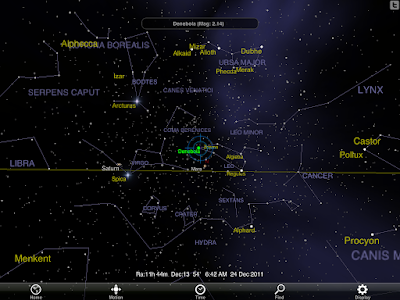
With the prospect for no snow this Christmas weekend, I was searching for yet another way to celebrate the natural world in conjunction with this most wassailing of holidays. Thanks to an email reminder from both Sky and Telescope as well as NASA, on Monday evening, December 26 right around sunset, the crescent moon and the planet Venus will be only a few degrees apart (~6º) in the western sky in what should be a most glorious celestial pairing of 2 vastly different worlds!
Around 4:15-4:30 pm, just as the sky is darkening into twilight, Venus will pop into view, shining brightly near the western sky's horizon. Less than a fist away (at full arm's length) towards the north or to the right will be the crescent moon! Look at the graphic below thanks to the app "Pocket Universe". In fact, upon close inspection and study of the diagram, Pluto, Uranus, and even Neptune are in the same general direction of the sky along the ecliptic plane as seen from the big blue marble! Kinda neat...don't cha think?
This is the perfect time to observe; when the moon and Venus decide to join in conjunction, especially during the holiday winter season, it should be a sight to fully savor.
Once the skies darken in total, and following the imbibing of your favorite beverage or indulging of your festive foods, note the moon's hidden face shining faintly thanks to "gegenschein" or what is otherwise known as counter shine. Sometimes it is mistaken, as this would be on Monday evening, as earthshine. Earthshine is simply the sunlight reflecting off the earth's atmosphere back onto the moon whereas gegenschein is at the "anti-solar" point, truly in opposition to the sun's celestial location.
Note the diagram explaining the concept of earthshine.
This phenomenon to be observed Monday is caused by Earthshine, a delicate veil of sunlight reflected from the big blue marble. Earthshine makes this phase of the moon one of my favorites! Look even higher in the sky and take note of beautiful Jupiter! Located now in the constellation of Pisces, Jupiter is the third brightest object in the sky, second to only Venus and the Moon! With little effort, most everyone should be able to enjoy their wander and beauty!
At least the NWS suggests that skies should be mostly clear to enjoy this astronomical observation, up until 8 pm when the skies go ~50% covered (blue line).
Here is another take on the skies for the near term...dark blue is a good thing!
For you early risers (like myself), look high in the sky and take note of Mars, Saturn, Arcturus, and Spica. See the graphic below to get your bearings to ID this spectacular sight in the early morning high sky. You are looking nearly overhead and slightly towards the south. It does appear that we will have clear skies over the next few mornings to note this celestial offering of wonderment for our hedonistic viewing pleasures! Use the handle of the "Big Dipper" to "Arc to Arcturus...then Speed onto Spica"! Saturn is located slightly east of Spica at this time. Orion and the Winter Triangle are heading westward and nearly setting early in the December morning sky. Get out there and check it out!
OK...again I've rambled enough. You see, I simply love this stuff and am in total awe of this natural world that is there for our interpretation and understanding! It really is that simple. To begin to wonder is to begin to understand and learn...OK, OK, OK...now sit back and enjoy what was written by Gordon Lightfoot and sung beautifully by Sarah McLaughlin. My wife turned me onto this song and it is spectacular.
Merry Christmas Y'all!
Smitty
AA: Looking up to the heavens. Note on Monday evening at sunset, Venus and the Crescent moon on the along the western horizon. It should be kinda cool!
The only thing that can be stated with much confidence is that appears the true Arctic air will be kept well north of our region and the much above normal December temps will continue. Through Dec 22, KMDT has averaged 5.3ºF above normal for all of December with an average temp of 40.3ºF. We hit 61ºF on the 6th and a low of 19ºF on the 12th. If not for the cold mornings that 2nd week, we'd be closer to 7-8 above! Here is the climatogram to this point. Note the "spring-like" last few days!
As for Christmas Eve, here is the official surface map from the Hydrometeorological prediction Center (HPC). Note the storm off the Carolina coast. That was our hope for a White Christmas. It now appears nearly certain that the storm will be well off to our SE and high pressure will keep our wx high and dry through the weekend.
Here is the forecast map for Christmas Day. Again, note lack of any strong storms across the lower 48 with the exception of the Pacific NW where an onshore flow of maritime polar air will result in mountain snows and lower elevation liquid sunshine. In fact, i do believe that the Pacific NW will be the area of focus of interesting winter wx over the next couple of weeks. News-making wx will be emanating from our friends in OR and WA!
Early next week, things get very murky with the modeling all over the place! The numerical guidance is having a very difficult time assessing the atmospheric situation as the equatorial Pacific is moving from a La Nina to a neutral ENSO (El Nino Southern Oscillation). Take a look at the modeling for the upcoming 3 month periods for the ENSO signal. Clearly, it suggests we are heading towards a neutral bias by next summer. With this changing energy in the earth's largest ocean, the atmospheric jet responds in ways not yet clearly understood and the medium range numerical guidance is struggling this year at best! Look at the NASA outlier! If that would verify, according to the analogs, we'd be looking at a very cold and stormy 2nd half of winter for the east. Don't hang your hat on that one!
Take a look at the comparison of the GFS and the Euro for the next Day8-10 period in the upper atmosphere. The Euro (left) has a zonal or even a SW flow whereas the GFS has a mean trough in the east. One thing to clue everyone on; however, is that when it is that cold in AK, it is often nearly impossible to get any real sustained cold into the eastern half of the US. It is now painfully evident that the Pacific "fire hose" is going to flood the lower 48 with Pacific origin air which spells a rather benign winter well into January. For those wanting to experience true winter wx and winter outdoor activities, you'll need to head to O Canada and MN, ME or the Rockies for skiing, ice fishing, or even just seeing frozen ponds, etc. This pattern does not bode well winter wx enthusiasts here in the eastern part of the US.
Well it will be January and with it opportunity for snow events, but it appears that for the next 2 weeks or so from my seat that any real cold will be kept NW of us. It does not mean there will be no snow, but any winter storm will likely be the proverbial "mixed bag" for persons living in south central PA. And I do believe the pattern will continue to serve up many opportunities for precip with such an active Pacific jet. However, the GFS keeps the storm track over the next week well to the south of PA across the SE US. Also note the incredible precip totals in the NW. Build that snow pack in the Cascades and northern Rockies!
OK, I've rambled long enough. In summation, just no real winter wx for us to get excited about around here. But one thing that is awesome is Pandora's Holiday Folk channel. I'm not one to usually tout a specific ideal or even infringe upon one's individual freedom of choice (just that strand of Libertarian in me!); yet I do highly recommend that you check out Pandora's Holiday Folk station for a wonderful mix of strings and keys playing a vast array of Christmas tunes. In stark contrast to what you'd be listening to on the above mentioned station, I'll leave y'all with this outstanding version of one of my favorite Christmas Carols. Just kinda gets you going...
Enjoy your potentially frantic pre-Christmas weekend Friday!
Smitty
AA: No real cold air in sight. It's been mild and will continue to be mild into January. Looks as if bulk of moisture stays south of us this upcoming week. Good tunes on Pandora Christmas Folk station!
Wow! Look at these temps as of 7am this winter solstice morning! For those of you who abhor winter, rest assured that ol' Sol is heading back northward as of 12:30 am earlier this morning. But with these sub-tropical temps, who needs the sun angle any higher?
Thursday looks to bring yet another wave of low pressure in what would be a normally sweet track for those wanting snow. However, as this low tracks to the south of PA this evening and into early Friday morning, we will see rain as there is NO COLD AIR in place to create snow flake construction in the upper levels! A bit disheartening for those of us hoping for a White Christmas. Here is the rain-snow line running over the northern part of Dauphin County. Oh sure, we may see a few flakes mixed in overnight if you're awake; however, this is a rain event for our sub-tropical locale. Snow will accumulate over northern PA to the tune of ~4" when all is said and done. We are looking at ~0.75" of rain by Friday morning. Take a look at the modeled totals of precip by Friday morning...
The heaviest of the rain will be falling around midnight as shown below. A slight shift NW of the storm's track, and we are looking at a heavy rainfall for ~3-6 hours overnight. As of now, it looks to be a moderate event delivering under an inch of rain.
Once this storm passes, colder air will try to invade us for the weekend; but cold is a stretch as temps will be near normal through Christmas Day. Here are the temps for when you are walking into Midnight Mass or putting toys together or having a bowl of gruel or cracking a Guinness Stout or whatever your fancy on Christmas Eve...
There will be a slight southerly flow that is the return of warmer air for the beginning of next week. The Arctic door is closed and into the foreseeable future, cold air is nowhere to be found in these parts. I sure would hate to have a vested interest in Mid-Atlantic Ski Resorts this early winter. Note the weak bubble of high pressure just off the east coast with its clockwise flow of air.
So allow me to end with this to all of you....
Enjoy your Christmas celebration!
Smitty
AA: Rainy Thursday night into early Friday, then clearing and seasonably cold for Christmas celebrations. Typical "normal" winter wx for the holiday weekend.
The lone wolf has finally backed down and now the Euro has a flat wave of low pressure passing well off to our south for Christmas Eve. So all of the major modeling has no chance of a White Christmas for us in southern PA! Here is the Euro's latest guidance...Just a little dollop of low pressure over coastal VA and NC....
And here is the Canadian's interpretation for Christmas Eve...
Nearly identical...don't cha think? And lastly the GFS...High pressure rules the roost!
Although time forbids me, even the GFS ensembles are all showing clear sailing for Christmas Day! Up until then, we will be seeing some precip through Friday in these parts. Here is the total precip through the early part of the weekend...It appears as if ~1 inch of liquid sunshine will be bestowed upon us by Saturday morning.
So there you have it...living in the sub tropics doesn't often result in a white December 25. Enjoy your Winter Solstice celebrations that will culminate around 12:30 am December 22! Oh yeah....and enjoy your Wednesday!
Smitty
AA: NO WHITE CHRISTMAS FOR YOU! Short enough now Timmy?