Just a very brief post to show how the rainfall will be over the next 48 hrs or so in these parts...very hit and very miss. The map below is a map from York County and its immediate surrounding counties showing the 24 rainfall totals ending either 6 or 7 am Tuesday morning. Note how a 10 mile distance can result in a 2+" difference in the rain gauge!
And that is why the rainfall totals over the next 3 days will not be very uniform across our region. Get under a few of these heavier rainers...and look out below! Here is the 3 day total rainfall from HPC...personally, I believe that we are a bit underdone in south central PA. Also note the "hot spot" along the Gulf coast. That is the potential trouble maker for this weekend...a nor'easter of sorts. It is actually part of the leftover upper air energy from Isaac...if you can believe that! That low pressure will be progged to move slowly north and east affecting us later in the weekend.
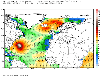
In addition, Hurricane Leslie will need to be watched closely. At the very least, the ocean will be rockin' all up and down the eastern seaboard this week into early next week!
Check out the wave-watch model for the ocean this weekend! 8-12 footers pounding the MD, DE and NJ beaches this weekend! It should be quite a show!
OK...gotta run for now. Enjoy your Tuesday!
Smitty
AA: Damp week through Thursday. Weekend, especially Sunday looks questionable as well. Wary eye on Leslie in the Atlantic.


No comments:
Post a Comment